130731-a Record rainfall could threaten Everglades wildlife
CBSlocal.com
July 31, 2013
MIAMI (CBSMiami) – The Everglades, one of the world’s most unique and complex ecosystems, has had its fair share of droughts over the years. But after this year’s early-season record rainfall, there is a surplus of water that officials say could potentially drown wildlife.
The recent flooding, according to Florida Fish and Wildlife Commission Conservationist Ron Bergeron, could possibly threaten the lives of bears, Florida Panthers, deer and other fur-bearing animals that call the Everglades home.
Bergeron, and other wildlife officials, are asking officials to take emergency action to help the situation before it could potentially get worse as there are still three months left in the 2013 hurricane season.
A comparable situation has happened before—and officials want action taken before the animals, including some endangered species, suffer.
“The current situation is eerily similar to what we had during the same time period in 1994 when 98 percent of fur-bearing wildlife got wiped out,” said Bergeron.
Bergeron, to alleviate the surplus water situation, is calling on government officials to open certain structures and utilize the new one-mile bridge on the south side of the Tamiami Trail to alleviate a perilous situation which is only expected to worsen over the next 30 days.
130731-b
130731-b Toxic algae confirmed in St. Lucie River; residents urged to avoid contact
WPTV.com - by Tyler Treadway, Scripps Treasure Coast Newspapers
July 31, 2013
MARTIN COUNTY — The bad news in the St. Lucie Estuary just got worse.
Tests by the Florida Fish and Wildlife Conservation Commission lab detected concentrations of Microcystis aeruginosa, a type of cyanobacteria that can produce toxins in the blue-green algae blooms that began covering the estuary early his week.
Because of the test results, the Florida Department of Health in Martin County is urging residents to avoid contact with algae in the entire estuary, from the St. Lucie Canal to the St. Lucie Inlet.
The tests do not confirm the presence of toxins. That would require further analysis, according to Kevin Baxter, a spokesman at the lab.
The toxins in Microcystis aeruginosa can be harmful to people and pets. Exposure to water containing toxins may cause nausea and vomiting if ingested and rash or hay fever symptoms if touched or inhaled. Mark Perry, executive director of the Florida Oceanographic Society in Stuart, compared the current blooms to the catastrophic explosion of blue-green algae that blanketed area waters in 2005.
"It sure looks like the Microcystis aeruginosa we had back in 2005," Perry said. "It’s got that same radiator-fluid color."
Perry called it "the devastation of an ecosystem that, besides being a thing of beauty, is the basis of our economy. To see it like this just makes you sick. In fact, it could literally make you sick."
Perry said the blooms probably aren’t going anywhere for a while, and they’re likely to cause some serious problems while they’re here and even after they’re gone.
"This bloom could last for several months," Perry said, "and it could be as bad as we’ve ever seen it."
The algae bloom in 2005 appeared during the summer and lasted until November, which Perry said might also be duplicated this year.
"With the influx of fresh water from local runoff and Lake Okeechobee dropping salinity levels, the nutrients all that water is bringing and the sunlight from long summer days, we’ve got the perfect combination of conditions for algae blooms," Perry said.
The algae blooms affect life in the estuary in several ways.
"First, seagrass is being shaded and can’t grow," he said. "Toxins in the algae can kill lots of little animals like shrimp and crabs. And animals that hunt for food in water that should be clear are being messed up because they can’t see their prey through the algae."
Even when the algae dies, Perry said, it’s a killer: The dying plant cells fall to the bottom and are eaten by bacteria that use up all the oxygen in the water.
"When the oxygen in the water goes below 5 milligrams per liter," Perry said, "that’s when the fish kills start."
If you spot blue-green algae, contact the Department of Environmental Protection at 772-467-5572.
To report fish kills or abnormal fish behavior call:
Florida Fish and Wildlife Conservation Commission, 1-800-636-0511
For more information, visit the Martin County Health Department's website.
130731-c
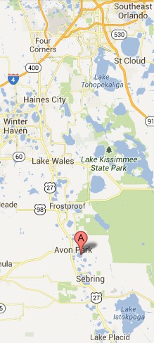
130731-c Yearly total still below historical average
NewsSun.com - by Christopher Tuffley
July 31, 2013
SEBRING -- News for drought-parched Central Florida is good. Lakes are gaining ground. Some docks that were high and dry at the beginning of the year now have water lapping their edges. A few are underwater.
"There has been a tremendous amount of rain," said county lakes manager Clell Ford. "We've actually seen at least 150 percent of normal rainfall."
Ford said Lake Jackson has risen 1 foot and Lake Placid about 2 feet. Lake Istokpoga is right where it should be.
According to the Southwest Florida Water Management District, the historic rainfall average from January to July in Highlands County is 21.89 inches. During the same time this year, there have been 21.67 inches.
"This is good," Ford said, "but we can take more."
Granville Kinsman, spokesman for the SWFWMD, expressed the same optimism.
"We've had a really, really good response," Kinsman said. "After 15 years of drought, we're looking good. The aquifers are stable and rivers above normal. Lake levels are the last thing to improve, and they are responding too -- including Lake Jackson."
One sign of the improvement is the culvert connecting Lake Sebring and Lake Jackson. Dry at the beginning of the year, water now flows with a strong current.
Kinsman explained decisions to move water through the system are made by SWFWMD's structure operations section, using guidelines set by the U.S. Army Corps of Engineers.
130730-a
130730-a Disaster for St. Lucie River, state if deadline missed on key Everglades project.
Palm Beach Post – Editorial by Randy Schultz
July 30, 2013
“Catastrophic.” A “state of emergency.” That is how state Sen. Joe Negron, R-Stuart, describes the condition of the St. Lucie River after weeks of assaults by dirty water drained from Lake Okeechobee. The discharges have left the coastal waters of Martin County “putrid.” And as he points out, Sen. Negron is less prone to hyperbole than many politicians.
Unfortunately, this is just the latest such catastrophe to hit the St. Lucie. The river received similar foulings in 1998, 2003, 2005 and 2010. It happens every time Lake Okeechobee gets high enough that the level becomes a threat to the dike surrounding the lake. At that point, the U.S. Army Corps of Engineers releases water — mostly east into the St. Lucie River and west into the Caloosahatchee River. Since Florida has allowed the lake to be a cesspool for farms and suburbs, the water carries pollution. This story continues on our new premium website for subscribers, MyPalmBeachPost.com. Continue reading/get access here »
130730-b
130730-b Red tide reduces scallop numbers in Southwest Florida
News-Press.com – by Mike Braun
July 30, 2013
Count over the weekend finds only 24 in Pine Island Sound.
A precipitous drop in the number of bay scallops found during the 2013 Pine Island Sound Scallop Search isn’t seen as a harbinger of the bivalve’s future, it was expected.
About 90 people in 20 boats found 24 scallops Saturday in a search of several sites around Pine Island Sound. “It is very low,” said Lee County Sea Grant agent Joy Hazell. “But it was expected due to the red tide.”
The search found 400 scallops in 2012, more than 1,000 in 2011 and 330 the year before. The annual count is sponsored by Florida Sea Grant and the Sanibel-Captiva Conservation Foundation.
All these results help researchers monitor the sound’s scallop population. “The search creates a story over time,” Hazell said. “We can’t say either way for the long-term health of the scallops.”
Until the mid-1960s, Pine Island Sound had a healthy bay scallop population that supported a million-dollar commercial scallop industry. But scallop populations crashed along Florida’s Gulf coast when water quality declined and seagrass beds disappeared as human population and development rose.
Organizations, including SCCF, Florida Sea Grant, Mote Marine Laboratory and the Florida Fish and Wildlife Conservation Commission, have tried to restore scallop populations by releasing millions of baby scallops in Gulf coast estuaries.
Hazell said the search covered specific portions of the sound and future searches could change the story.
“This one year is a snapshot,” she said. “If it continues next year then we’ll have to talk about more aggressive plans. We need data over time.”
Since the edible scallop is an annual “crop” she said, the research is done to see if the population can sustain itself over time.
Since 2000 there have been instances of seeding of bay scallop embryos into Pine Island Sound, Hazell said.
The red tide that affected the area this past winter was telling, she said, in depressing scallop numbers. “We expected it to impact the count,” she said.
Other factors that can affect scallops such as problems with seagrass beds, were not an issue.
“The seagrass beds were OK,” Hazell said. “There was some sloughing due to fresh water, but volunteers reported some very thick beds.”
Hazell said she was comforted to see the volunteers come out to help. “It was great to have the people come out to do citizen science,” she said. “Just not the result.”
Sea Scout adviser Susie Hassett was on her fourth search for scallops.
She said volunteers encountered sea urchins and sea stars and dark shell bivalves but few scallops.
“We’ve seen this happen before,” she said, primarily in 2005.
Hassett noted most scallops that were found were in areas that had been seeded in previous years.
130729-a Draining swollen Lake Okeechobee hurts coastal communities
Sun Sentinel - by Andy Reid
July 29, 2013
The green ooze of algae blooms, fleeing fish and no-swimming warnings: Welcome to South Florida's flood-control dumping grounds.
The polluting consequences of draining Lake Okeechobee to keep South Florida dry are dumped on coastal communities such as Stuart, Port Salerno and Jensen Beach to the north, which otherwise wouldn't be at risk of flooding from Florida's great lake.
Now businesses in Stuart and those other coastal communities are worried about the economic impact of losing customers during another summer where they pay the price for South Florida's man-made flood control problems.
It's as bad for the economy as it is for the environment," said Leon Abood, a real estate agent in Stuart who also heads the Rivers Coalition, which advocates an end to the damaging discharges. "There is no end in sight. … We have had it."
During this rainier-than-usual summer, the flooding risk Lake Okeechobee poses to South Florida has triggered billions of gallons of lake water to be dumped each day through the St. Lucie and Caloosahatchee rivers and out to sea.
Already, coastal fishing grounds are suffering and water in some areas is considered unsafe for humans. And the dumping is getting worse. The Army Corps of Engineers Thursday announced that it was ratcheting up to maximum lake discharges into the rivers because lake waters continue to rise.
It's a problem that repeats itself whenever Lake Okeechobee's water level threatens to overburden the troubled dike that protects lakeside communities and sugar cane fields from flooding.
Fixing the problem involves jump-starting backlogged Everglades restoration projects that would store and clean up stormwater; redirecting more of it to the Everglades instead of out to sea. But those multibillion-dollar efforts come at a steep cost to taxpayers and will take decades to complete.
"It's horrible. … Where's our protection?" Mark Perry, of the Florida Oceanographic Society in Stuart, said while looking at darker-than-usual river water clouded by dumping from Lake Okeechobee. "We have artificially connected [the waterways] and now we have nowhere else to go with the lake water expected east and west."
Coastal advocates focus much of the blame for the Lake Okeechobee dumping on the politically influential sugar industry, which dominates the vast agricultural area south of the lake that sits on former Everglades land. Protecting crops from flooding limits how much lake water can flow south.
Efforts to "over drain" the Everglades means "the rest of us suffer," Abood said.
Lake Okeechobee's water once naturally overlapped its southern rim, flowing south in shallow sheets that replenished the Everglades.
But then farming and a growing population got in the way, leading to South Florida's vast system of levees, drainage canals and pumps to guard against flooding.
That includes Lake Okeechobee's 143-mile-long Herbert Hoover Dike, built in the 1930s in the aftermath of thousands of flooding deaths from hurricanes. The Army Corps uses canals dug to link the lake to the Caloosahatchee and St. Lucie rivers as the main outlets to drain lake water out to sea.
Today, the lake's earthen dike is in the midst of a decades-long rehab project. Rising lake water levels increase the threat of erosion and the creation of cavities within the dike that can lead to a breach.
The lake has been rising about 6 inches per week during July, according to the Army Corps. During the past week, lake levels surged passed the upper end of the 12.5 to 15.5 foot range the Army Corps tries to maintain to ease the strain on the dike.
On Friday, the lake was 15.63 feet above sea level, 3.5 feet higher than this time last year. When the lake goes above 17 feet, the corps considers the dike at a "significantly higher" risk of a breach.
On the east coast, the lake discharges that have been flowing since May have affected the delicate mix of fresh and salt water in the St. Lucie River Estuary. In addition to making the estuary less salty, the lake water also brings with it loads of sediment and pollutants that are clouding the river.
The poor water conditions are killing off oyster reefs and seagrass beds that are home to the species that help fish, manatees and wading birds survive.
Algae blooms are already invading the river and connected waterways and are expect to get worse. That raises the potential for fish kills and poses a health risk for swimmers and fishermen alike. Related: High Water Levels at Florida's Lake Okeechobee Insurance Journal
130729-b
130729-b Group gathering signatures to restore land conservation funding
WFSU.org – by Jessica Palombo
July 29, 2013
A coalition of Florida environmental groups is ratcheting up its campaign for a state constitutional amendment setting aside money for land conservation. Group leaders say the strategy is necessary after conservation program budgets were slashed over the past few years.
The group, calling itself Florida’s Water and Land Legacy, has about a quarter of the nearly 700,000 petition signatures it needs to put a measure on next year’s ballot. The group proposes setting aside just less than 1 percent of the state budget to buy and restore nature preserves.
Field director Aliki Moncrief says there’s a disconnect between what the public wants and what the Legislature has done.
“People on the street, when you talk to them about conservation, it hasn’t been a politicized issue. So it’s unfortunate that on the budget levels, it hasn’t gotten the support since ’09 that it deserves," she says.
The proposed amendment would earmark part of the revenue from a tax on property transfers for acquiring and managing parks, preserves and urban green spaces.
The group has five months left to get the rest of the necessary signatures. A signature-gathering firm will ramp up the effort in early September.
130729-c
130729- Plan to end the dirty water releases from Lake O
FOX4now - by Warren Wright
July 29, 2013
Whats taking so long ?
FORT MYERS, Fla. -Dark murky water released from Lake Okeechobee is turning the coast of Fort Myers Beach from blue to brown.
Many worry what this will do to tourism -- and the ecosystem.
Some say the water release shouldn't be happening in the first place.
There is a plan that could dramatically improve our water quality... but it's just sitting on the shelf waiting for congress to act!
Pictures show a wall of black water, saturated with fertilizers and waste... advancing ... swallowing up our local beaches.
Its not a pleasant experience for tourists and beach goers, who pump billions into the local economy.
Just ask those who work for the Lee County Visitors Convention Bureau.
Nancy Hamilton says "they love our beaches and the outdoor environment. so we all must look after that and be good stewards of our land."
There is a plan to be good stewards, developed by the Army Corps of Engineers.
It requires half a million acre feet of water storage.
The first of several reservoirs is called C-43... located halfway between Fort Myers and Lake Okeechobee.
Its 170 thousand acres.
There also needs to be reservoirs to the North... in the Kissimmee valley... to the east along Port Saint Lucy and to the south as well.
Then, restore the natural waterflow into the Everglades.
Believe it or not, land for C-43 was purchased 15 years ago... and still nothing has happened.
Kurt Harclerode with the Lee County Natural Resources Division says "the land has been purchased, we've done all the engineering the permits in hand. that project is what we would consider shovel ready."
and, congress has yet to do anything about it."
The Water Resource Development Act, if congress would pass it, would cover the cost.
Environmentalists, businessmen and government officials are asking everyone to get involved.
Nancy Hamilton says "we need to take action in whatever form we can. personally - maybe people write their congress person and tell them how important it is to our area. "
Because if we as a community don't start applying pressure, then progress will remain very slow.
Kurt Harclerode adds "this is going to take decades to complete."
Congressman Radel says he hopes that congress will pass the water bill by the end of this year.
Congress hasn't been able to agree on any water quality issues for the past seven years.
130729-d
130729-d Reservoir to the rescue in Hendry County
News-Press.com – by Chad Gillis
July 29, 2013
With all the extra water, restoration project installation comes in handy
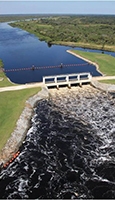
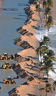
A state agency scrambling to deal with the effects of rising water levels turned to a Hendry County Everglades restoration project Monday as a way to sop up the recent rainfall and Lake Okeechobee discharges.
Engineers with the South Florida Water Management District started pumping water from the Caloosahatchee River (the Townsend Canal specifically) and sending it to the $580 million C-43 West Basin Reservoir off State Road 80. The agency plans to build two storage cells on the 11,000 acres as a way to help balance fresh and saltwater levels in the Caloosahatchee estuary.
Water management district engineer Tom McKernon said the site, if approved for funding by Congress, will eventually be capable of storing 170,000 acre-feet of water, or about 55 billion gallons.
“We’re going to put as much water on this land as we can,” McKernon said while driving to the testing site. “We’ve had four straight months of above-average rainfall, which has resulted in most of South Florida being saturated. And obviously Lake Okeechobee levels are rising quickly.”
Water levels across South Florida have risen several feet since early June, the beginning of the rainy season. Stormwater run-off from the Caloosahatchee River watershed, which extends from Lake Okeechobee to the Gulf of Mexico, combined with Lake Okeechobee releases have functionally killed the Calooshatchee estuary — moving the brackish nursery grounds into ocean waters.
Although Lake Okeechobee levels (15.74 feet on Monday) are managed by the Army Corps of Engineers, the Water Management District must deal with some of effects of the discharges. The Army Corps uses the Caloosahatchee and St. Lucie Rivers as giant ditches to keep Okeechobee waters under control and off residential and farming lands to the south.
Last week the Army Corps announced that all drainage systems are open, and “not just the usual ones.” Flows were measured at 12,540 cubic feet per second, nearly three times the volume needed to damage sea grasses in the estuary. The average flow at W.P Franklin Lock and Dam was more than 8,000 cubic feet per second for a 30-day period. The water ceiling to prevent environmental damage on the coast is 4,500 cubic feet per second.
Heavy freshwater flows bring large volumes of tannin-stained waters to coastal estuaries. The water in San Carlos Bay, near the mouth of the Caloosahatchee, was so dark last week that light was penetrating less than two feet, which is not enough to sustain several species of sea grasses. Scientists with the Sanibel-Captiva Conservation Foundation reported some of the worst estuary conditions on record.
Water management governing board member Mitch Hutchcraft said he’s optimistic about the future of the Caloosahatchee River but that fixing the ecological problems will likely take many years and millions of dollars.
“We’ve had four months of above-average rainfall, and that’s the first time that’s happened since 1997,” Hutchcraft said. “We need to reduce peak flows when we have lots of rain, like the conditions we’re experiencing now. And then hold that water so when we have low flows we can release some fresh water to keep the salinity (levels) from coming way up the river.”
The National Oceanic and Atmospheric Administration is calling for 13 to 20 named storms, between seven and 11 hurricanes and three to six major hurricanes — Category 3 and higher. An average season equates to 12 named storms and six hurricanes, with three of those major storms.
130729-e
130729-e Texas water contamination linked to fracking sites
News Talk Florida
July 29,2013
The toxic substances, including arsenic, selenium and strontium, were all found at levels higher than recommended levels in wells in and around the Barnett Shale, an important reservoir of natural gas in North Texas.
The study, led by Kevin Schug, professor of chemistry and biochemistry at the University of Texas (UT) at Arlington, took water samples from 100 private wells. Of these, 91 were taken from wells that were within a five kilometre radius of a natural gas drilling site, while another nine were taken from “reference areas” of more than 14 kilometres from a drilling site.
The highest levels of contaminants were discovered within three kilometres of natural gas wells. While many of the heavy metals identified in the samples are naturally present in groundwater, the researchers found that they were present at levels higher than historical average
130728-a
130728-a FDEP using new technology to examine water quality
The News Herald - by Zack McDonald
July 28, 2013
PANAMA CITY BEACH — Florida Department of Environmental Protection officials announced an initiative to develop new rules refining water quality standards for beach and recreational waters throughout the state.
The FDEP will propose updates to Florida’s bacteria criteria for recreational waters, applying guidance from the EPA. The changes ultimately will be presented to the Florida Environmental Regulation Commission and EPA for approval after a series of technical advisory committee meetings and other public workshops.
New laboratory tools and assessment methods recently allowed FDEP scientists to quickly identify whether fecal bacteria, an indicator for the possible presence of pathogens, are related to humans, animals or other sources. The new lab equipment and methods use DNA analyses of bacteria and modern tracers, including artificial sweeteners, to identify human waste from other sources, according to the FDEP.
Armed with that knowledge, the FDEP can more quickly identify and reduce the sources of pathogens in recreational waters and act to protect public health.
However, the science needed to set water quality criteria based on direct measurement of pathogens has not yet been developed, so FDEP devised a multi-pronged approach using the latest technology.
“Measuring fecal bacteria levels is easy,” said Drew Bartlett, Division of Environmental Assessment and Restoration director. “Unfortunately, readily distinguishing the sources of the bacteria and the potentially harmful pathogens that may go along with them has been beyond scientific capabilities.”
Bartlett said since the tools are now available rules and protocols can be crafted to reduce the sources of the problems, restore water quality and protect public health.
A technical advisory committee will be formed to guide FDEP on the scientific intricacies of the rules since they will be implemented using new scientific technologies. The panel of experts includes representatives of the EPA, the Florida Department of Health, the Florida Department of Agriculture and Consumer Services, local governments and the academic community, according to FDEP.
The FDEP also will propose changes to its water quality assessment strategy to take advantage of the new lab tools and land-use surveys to determine where elevated bacteria levels may indicate an increased risk to human health, officials said.
Where high bacteria levels are detected, and using the most advanced source tracking capabilities, FDEP officials will direct actions that reduce the sources of the problems and restore water quality.
The first committee meeting will be held Aug. 20 at 9 a.m. in the Florida Department of Environmental Protection, Bob Martinez Center, Room 609, 2600 Blair Stone Road in Tallahassee.
130728-b
Water releases from
Lake Okeechobee hurt
the coastal communities
130728-b Lake O draining to protect South Florida hurts coastal communities
Sun Sentinel – by Andy Reid
July 28, 2013
The green ooze of algae blooms, fleeing fish and no-swimming warnings: Welcome to South Florida's flood-control dumping grounds.
The polluting consequences of draining Lake Okeechobee to keep South Florida dry are dumped on coastal communities such as Stuart, Port Salerno and Jensen Beach to the north, which otherwise wouldn't be at risk of flooding from Florida's great lake.
Now businesses in Stuart and those other coastal communities are worried about the economic impact of losing customers during another summer where they pay price for South Florida's manmade flood control problems.
"It's as bad for the economy as it is for the environment," said Leon Abood, a real estate agent in Stuart who also heads the Rivers Coalition, which advocates an end to the damaging discharges. "There is no end in sight. … We have had it."
During this rainier-than-usual summer, the flooding risk Lake Okeechobee poses to South Florida has triggered billions of gallons of lake water to be dumped each day through the St. Lucie and Caloosahatchee rivers and out to sea.
Already, coastal fishing grounds are suffering and water in some areas is considered unsafe for humans. And the dumping is getting worse. The Army Corps of Engineers Thursday announced that it was ratcheting up to maximum lake discharges into the rivers because lake waters continue to rise.
It's a problem that repeats itself whenever Lake Okeechobee's water level threatens to overburden the troubled dike that protects lakeside communities and sugar cane fields from flooding.
Fixing the problem involves jumpstarting backlogged Everglades restoration projects that would store and clean up stormwater; redirecting more of it to the Everglades instead of out to sea. But those multibillion-dollar efforts come at a steep cost to taxpayers and will take decades to complete.
"It's horrible. … Where's our protection?" Mark Perry, of the Florida Oceanographic Society in Stuart, said while looking at darker-than-usual river water clouded by dumping from Lake Okeechobee. "We have artificially connected [the waterways] and now we have nowhere else to go with the lake water expected east and west."
Coastal advocates focus much of the blame for the Lake Okeechobee dumping on the politically influential sugar industry, which dominates the vast agricultural area south of the lake that sits on former Everglades land. Protecting crops from flooding limits how much lake water can flow south.
Efforts to "over drain" the Everglades means "the rest of us suffer," Abood said.
Lake Okeechobee's water once naturally overlapped its southern rim, flowing south in shallow sheets that replenished the Everglades.
But then farming and a growing population got in the way, leading to South Florida's vast system of levees, drainage canals and pumps to guard against flooding.
That includes Lake Okeechobee's 143-mile-long Herbert Hoover Dike, built in the 1930s in the aftermath of thousands of flooding deaths from hurricanes. The Army Corps uses canals dug to link the lake to the Caloosahatchee and St. Lucie rivers as the main outlets to drain lake water out to sea.
Today, the lake's earthen dike is in the midst of a decades-long rehab project. Rising lake water levels increase the threat of erosion and the creation of cavities within the dike that can lead to a breach.
The lake has been rising about 6 inches per week during July, according to the Army Corps. During the past week, lake levels surged passed the upper end of the 12.5 to 15.5 foot range the Army Corps tries to maintain to ease the strain on the dike.
On Friday, the lake was 15.63 feet above sea level, 3.5 feet higher than this time last year. When the lake goes above 17 feet, the corps considers the dike at a "significantly higher" risk of a breach.
On the east coast, the lake discharges that have been flowing since May have affected the delicate mix of fresh and salt water in the St. Lucie River Estuary. In addition to making the estuary less salty, the lake water also brings with it loads of sediment and pollutants that are clouding the river.
The poor water conditions are killing off oyster reefs and seagrass beds that are home to the species that help fish, manatees and wading birds survive.
Algae blooms are already invading the river and connected waterways and are expect to get worse. That raises the potential for fish kills and poses a health risk for swimmers and fishermen alike.
The water conditions threaten to scare away Snook, tarpon, redfish, trout and other potential fish prized by fishermen.
"You can't even see the bottom," Perry said, peering into the clouded waters near the Roosevelt Bridge in Stuart, where he should be able to see oyster beds below the surface. "Nasty looking water. … It makes you sick."
When water conditions in the St. Lucie River Estuary go bad, business leaders say the damage reaches beyond wildlife habitat. Fishing trips get cancelled, hotel rooms remain vacant, bait shops lose business and even houses are harder to sell.
Fishing boat Capt. Ray Winters said a light catch during a recent charter trip prompted his customers to cancel the second day of their outing with him on the St. Lucie River.
Winters said the lake discharges have left the river darker than he has seen in nearly a decade. The influx of fresh water is scaring off fish used to living in saltier conditions.
"Almost the entire lagoon is [in] terrible condition," said Winters, based in Port Salerno. "It's affecting my ability to make money. … This time of the year it should be pretty easy to catch fish."
Years of studies, plans and politicians' promises have failed to deliver drainage solutions, said Henry Caimotto, who for nearly 30 years has operated the Snook Nook bait shop in Jensen Beach.
"Who on earth would think in this [time] that you would have to be afraid of going into the water?" Caimotto asked. "My area just gets ... beat."
While frustration grows for people living and working along the St. Lucie River Estuary, hurdles remain for Everglades restoration.
The Army Corps of Engineers and South Florida Water Management District have yet to reach an agreement on how to divvy up the costs of a new $2 billion Central Everglades restoration plan. That plan includes moving more water from Lake Okeechobee south to the Everglades, but costs and water quality standards have been sticking points in the proposal.
The concern is that missing out on this round of federal funding could lead to a seven-year delay for the next congressional approval.
In a letter to district leaders calling for action, the Everglades Foundation pointed to the crisis in the St. Lucie River that "will become a devastating event to the local economy and ecosystem," Everglades Foundation Executive Director Eric Eikenberg wrote.
"Shame on all of us if we allow bureaucratic gobbledygook to cause delay and solutions missed," Eikenberg wrote.
130728-c
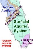
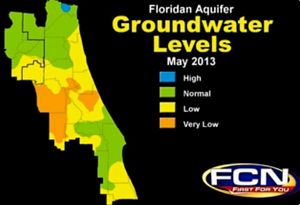
130728-c Restoring Florida wetlands would give Florida Aquifer a break
TheLedger.com
July 28, 2013
Tom Palmer's July 21 article "Floridan Aquifer Has Certain Limits" is right on point. The Floridan aquifer has been overpumped, which has caused problems for local rivers, springs and lakes.
For augmenting water supply, he explained the "traditional" alternatives (i.e., tapping rivers) being considered by short-term-thinking agencies, but one very important alternative that should be considered above all others by local leaders was not mentioned.
Many areas of Polk County used to retain huge quantities of water. These natural wetlands stored and treated floodwaters, and slowly released this water to rivers and streams.
Our sandy soils would percolate water into the aquifer and lakes. Now, wetlands are drained and sandy soils have been paved over.
It is not too late to reverse the policy of drain and pave. We need to act before the next wave of development takes away this option.
Estimates for the Peace Creek Watershed alone, which covers about 15 percent of the county, indicate that 27 billion gallons of water could be stored if we restored lost wetlands. There are few houses on the land needed.
Using the natural system costs less and provides many more benefits than man-made structural solutions.
If we constructed man-made reservoirs to store this water, it would cost billions.
Circle B Reserve is a great example of how Polk County should be spending its money for water resources.
Plus, these types of projects create places to walk, ride bikes and experience nature.
It doesn't hurt that these types of projects encourage healthier citizens and high-quality economic growth.
If we do not pursue these kinds of smart-planning options, we are destined to become just another suburb to Tampa and Orlando, and diminish what makes us unique — our lakes and natural areas.
FRANCES HOWELL-COLEMAN, Winter Haven, FL.
130728-d
130728-d Seagrass experiment tries lagoon transplants
DaytonaBeachNewsJ. - by Dinah Voyles Pulver
July 28, 2013
The St. Johns River Water Management District started a pilot project last week to study seagrass and determine if seagrass from healthy beds in the Indian River Lagoon could be transplanted to barren areas where the seagrass has died.
After decades of work to restore seagrasses in the lagoon, a couple of large algal blooms in 2011 and 2012 are being blamed for wiping out 47,000 acres of seagrass.
With state and federal permits, the district partnered with Florida Atlantic University to dig up small amounts of healthy shoal grass from the lagoon in Titusville and Vero Beach. The grass was transplanted to three barren areas — near the Pineda Causeway (in Banana River Lagoon) and Melbourne in Brevard County, and Wabasso in Indian River County.
District scientists will monitor the sites for two years and assess the survival, health and rate of growth/spread, considered crucial for determining recovery potential.
130728-e
130728-e Speaker: Rising sea levels unstoppable
Palm Beach Daily News - by William Kelly
July 28, 2013
Dramatic changes coming as sea rises and shoreline moves inland, oceanographer says
Staff Writer
Humanity has arrived at a geological intersection, and residents who live along the low-lying, densely populated coast of southeast Florida have a front row seat.
Dramatic changes will unfold in the next few decades as the sea continues to rise and the shoreline moves inland. It is time to think about the large-scale financial and societal impacts, John Englander, an oceanographer, global ocean explorer and author, told an audience on Friday.
“The world is changing,” he said. “It is stunning, how quickly it is changing.”
Englander, who penned the book High Tide on Main Street: Rising Sea Level and the Coming Coastal Crisis, was the keynote speaker at a symposium on rising sea levels. More than 200 people attended the event at Oxbridge Academy.
Englander’s remarks were followed by discussions among panelists who also took questions from the audience. The panelists including educators, government leaders, Realtors, water and natural resource managers, and others. Based on the discussions, the most pressing issues confronting South Florida include flooding; the threat to coastal development, beaches and tourism; property values; and the saltwater contamination of the fresh-water supply. Jim Sackett, retired anchor from WPTV NewsChannel 5, moderated.
Fluctuations in ocean levels are not a new phenomenon for the earth. During the last peak ice age 20,000 years ago — the blink of an eye in geological time — the sea level was 390 feet below where it is today, Englander said. For the last 6,000 years, it has remained essentially constant. But now it is rising (about 8 inches over the last century) and will continue to do so for at least 1,000 years, Englander said.
This marks the first time that human civilization has collided with climate change and rising seas, he said.
The arctic has been frozen for three million years. Now the ice there is disappearing by as much as 7 percent a year, he said. As recently as 1970, scientists would not have thought that to be possible.
“Some September in the next 20 years, the arctic will be completely devoid of ice, and the period of time when it is ice-free will gradually expand each year for decades,” he said.
The arctic ice is important to the climate because it reflects 90 percent of the sun’s light, rather than absorbing it. Once that region turns to dark ocean, it will reflect only 6 percent of the light, he said. “The planet will absorb more heat. There’s nothing we can do to stop it right now.”
Most people don’t understand the science, he said. Most of Englander’s audiences believe that the melting polar ice cap contributes to sea level rise, Englander said. The melting of the arctic ice is significant because it is proof that the planet is warming. But it doesn’t add to sea level rise.
Unlike the ice sheets on Greenland and Antarctica, the arctic ice is not on land. It is frozen ocean, with 10 percent above the surface. The ice displaces the water, so when it melts away it won’t change the level of the seas.
If all the ice on Greenland were to melt, that would raise the sea level by 24 feet, he said. That could happen in about 3,000 years, he said (Antarctica has seven times more ice than Greenland).
Ninety percent of the world’s glaciers are receding, and all will eventually disappear. The collective impact of that is 2 to 3 feet of sea level rise.
Humans can’t reverse the changes in climate and sea level, though it may eventually be slowed. Meanwhile, there is no point in getting depressed about it, he said.
“We are an amazingly adaptive species,” he said. “It is probably our greatest strength. It may be emotionally challenging, but we’re resilient. We find ways to do that.”
130727-
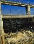
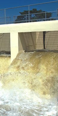
130727- High water levels at Florida's Lake Okeechobee
Associated Press
July 27, 2013
WEST PALM BEACH, Fla. — The Army Corps of Engineers has activated its emergency operations center in response to high water levels at Lake Okeechobee.
The corps' emergency operations center in Jacksonville was activated Friday. Officials say the lake has been rising about 6 inches a week and stood at 15.66 feet by Saturday.
The corps fully opened its locks around the lake Thursday to protect the aging Herbert Hoover Dike. Corps spokeswoman Jenn Miller tells The Palm Beach Post (http://bit.ly/177nLGG) that inspectors found "minor flow increases" in areas where the earthen dike was known to seep.
Miller says the seepage was "nothing serious," but the corps wanted to be ready to react to any effects from Tropical Storm Dorian.
Forecasters at the National Hurricane Center in Miami said Saturday that Dorian was expected to weaken as the disorganized storm system continued spinning west over the open Atlantic.
"If this storm was not currently in the Atlantic, we would not be activating the EOC," Miller said. "Usually we activate the EOC in regards to lake levels when we start daily inspections, which would begin if the lake reached 16.5 feet."
Weekly inspections of the dike began when the lake's water level rose above 15.5 feet on Monday.
The corps controls the dike and locks around Lake Okeechobee, which covers 730 square miles. On Thursday, the corps fully opened the locks to drain water from the lake to keep the water level from rising too high and putting too much pressure on the dike, parts of which date to the 1930s.
In the corps' 2014 budget request, problems with the dike were described as so serious that it was given a Level 1 risk ranking. "Structures in this class are critically near failure or extremely high risk under normal operations without intervention," officials wrote. "In this case, there is a concern even at a relatively low pool level due to the limitations of the current outlet structures."
The budget request also noted seepage, also known as piping, as a concern.
"Currently, the probability of catastrophic dike failure due to piping is unacceptably high. Such an event would produce flooding, which could (depending on its location) lead to the loss of life and/or significant economic damage," officials wrote.
130726-a
Florida early map
130726-a 5 theories why Florida is so dysfunctional
Salon.com – by Steven Rosenfeld
July 26, 2013
Chatty cops and a nutty governor are two of roughly two million reasons the state has drawn the nation's ire.
Every state has something shameful to hide. But Florida is the weirdest state. It’s one thing to go online and look at the latest “Crazy Florida” lists or “Weird Florida” tours. If you Google, “Why is Florida,” before you type in another letter, it fills in, “so crazy,” “so hot,” “so weird.” But joking aside, if you drive south from Alabama and Georgia and turn on the nightly television news, you are going to find behavior that ranges from dumb and dumber to dark and despicable.
“A Florida man shot himself in his penis and testicles while claiming to be cleaning his gun,” blared one ABC-TV affiliate. “A Florida man whose hand was bitten off by a nine-foot alligator now faces charges of feeding the animal,” blared another. And state wildlife officials also were not too thrilled with a company whose business is bringing alligators with their mouths taped shut to kids’ birthday pool parties (for a $175 fee).
But then the local news goes gothic. A Florida man was upset that his wife didn’t thaw the frozen pizza and shoved her face into a dog bowl, police said. Another man forced his wife to swallow her diamond engagement ring after she announced that she was leaving. In another bad pizza story, a man punched the delivery boy after he forget garlic knots.
And then comes cannibalism. Another man “chopped off his victim’s head, removed part of the brain and an eyeball, put them in a plastic bag, walked 12 blocks to this cemetery, Lakeview Cemetery, and then ate them,” WTHH-TV reported. Other skin-eating criminals also made national news, with details too gross to mention.
So what is it? Is there something in the state’s character that delights in proving—or telling the world again and again—that Floridian facts are stranger than fiction?
“A Florida man is dead after competing in a bug eating contest at a reptile store,” another station reported. Another cockroach-eating story starred a preacher wanting to attract new parishioners. The state sponsors python killing contests, though some Floridians keep them at home as pets—until they are herded like cattle and confiscated.
The “weird Florida” list goes on and on—and then it moves into the political world.
Florida’s bad politics startled the nation in 2000, when the U.S. Supreme Court stopped a presidential recount and gave the White House to George W. Bush. Its current governor, Rick Scott, is one of America’s worst. He was elected after touting his years as CEO of Columbia/HCA, a big hospital chain that paid a total of $1.7 billion in fines for taxpayer-bilking Medicaid fraud felonies that were mostly committed while he was in charge. He spent $75 million of his money on his 2010 race. The fox now runs the henhouse.
At times, Scott, a Tea Party Republican, seems like a buffoon. At other times, he’s bent on destroying Florida government. He’s mistakenly given out phone sex line numbers at press conferences and signed a bill that unknowingly banned computers and smart phones at Internet cafes. He was called one of the nation’s worst governors by the Chronicle of Higher Education for wanting to phase out funding for the humanities. Scott resurrected a slew of Jim Crow-era voting tactics before the 2012 election, including false claims that 180,000 aliens were on voter rolls and shutting down voter registration drives.
Beyond Scott, Florida’s justice system cannot shake its inescapable racist reputation. It’s not just that the Trayvon Martin prosecution team could not convict George Zimmerman. The same prosecutor sent a black women—a young mother—to jail for 20 years for firing a warning shot after her husband, a known domestic abuser, threatened her.
Florida is a state of extremes. It has the most bugs, the highest identity theft rate in the nation, the flattest roads and the worst elderly drivers. Two of its cities, Pensacola and Jacksonville, rank in the top 10 nationally for most toxic drinking water. More cities are among the nation’s top 10 with stickiest weather: Apalachicola and Gainesville. It has the fourth most volatile economy, with one quarter of its 19.3 million residents losing one-fourth of their income in 2008 economic crash. Why? Why? Why?
California has the most poisonous snakes, but it does not have the Sunshine State’s snake obsessions. Nor does it have a detective’s daughter displaying an ounce of cocaine from the police locker for a grade-school science project (involving sniffer dogs).
Native Floridians tend to blame everyone but native Floridians for the state’s reputation.
As UrbanDictionary.comnotes, white Floridians with pre-Civil War roots are proud to be called “crackers,” and are known for fishing and swimming in lakes and rivers; knowing what swamp cabbage is and how to cook it; eating cane syrup on biscuits and gravy on squirrel and rice; and knowing to take off one’s hat when hearing Dixie or any Lynyrd Skynyrd song.
“This just makes me want to laugh,” replied Casey Schmidt, to CBS’s Miami affiliate when they asked about Florida’s weird reputation. “You say people down here only care about themselves, well that may be true. Until we know who you are and what crazy ideas you are bringing from some other crazy state, we are just going to take care of ourselves. If you don’t like the way we’re living just leave this long-haired country boy alone.”
Using boomer Southern rock lyrics to express “screw you” sentiments—courtesy of the Charlie Daniels Band—is predictable enough. But other writers to the same blog had more insightful comments.
“I live here in Pinellas County and I believe it’s a combination of extreme poverty from low paying jobs, heat, and no access to mental-health care (unaffordable health insurance and very hard to qualify for Medicaid),” another said. “You get desperate, depressed, angry, and eventually just don’t care about anything.”
What do other Florida watchers say? There are a half-dozen good theories accounting for the beat-on-Florida bandwagon. 1. Florida cops don’t keep quiet.
NPR’s Brooke Gladstone, the New Yorker who co-hosts “On The Media,” last year interviewed Florida newspaper reporter Will Greenlee about the state’s off-the-charts crime stories. The police reporter said Florida’s permissive open-records laws gives the media inordinate access to detailed police files, where they find the lurid tales. 2. The curious mix of people drawn there.
Allison Ford, theorizing at DivineCaroline.com, said Florida is one of those states that is more populated by people who come from elsewhere than by natives. This includes old people, immigrants, the very religious, “carpetbaggers and the nouveau riche from the rest of the country,” rednecks and tourists, as she said. “Florida has about 19 million residents. Is it any surprise that you have more weird news than Wyoming?”
Ford does not even mention that Miami has long been the destination of choice for Latin America’s exiles, most notably from Cuba. Vanquished military dictators also favor the region, as well as impoverished Haitians. Ex-New Yorkers linger on the Atlantic coast. Midwesterners go to the Gulf coast. And that’s just the southland. 3. The law—if you can call it that!
Somerset Maugham’s quote about the French Riviera has become Florida’s unofficial tag line—a “sunny place for shady people.” Roger Stone, one of Richard Nixon’s henchmen, told the New Yorker that he moved to Miami in the 1990s “because I fit right in.” To say that Florida has a loose regulatory environment barely states it. People move there to buy homes that can’t be seized in bankruptcy proceedings. There are loose gun laws, of which the Stand Your Ground law is but one example. Ford noted the state has “no system to monitor the distribution of prescription drugs” and there’s no state income tax.
“While plenty of people come to Florida looking for simply a better life or better weather, the state attracts a contingent of people who come for more illicit or opportunistic reasons, and these people tend to make the news,” she said, citing its loose laws and frontier mentality. 4. The land and the weather.
It’s not just the lack of four distinct seasons, but the mix of heat, humidity, hurricanes and native flora and fauna that’s not found in the rest of America. As Swamplandia! author and Miami-Dade native Karen Russell told “On The Media,” it all starts with the weather. “You’re just bathed in this unchanging summer like all the time,” she said. “The shape of it [the state] too, it’s like a lot of strangeness just travels the spine of the country and seems to land there… I think there’s some physics to it.”
Scientists—not just writers—have found there are a range of mental and physical health issues that arise when people live above 80 degrees Fahrenheit. One paper, based on 13 years of Australian data, “observed a positive association between ambient temperature and hospital admissions for mental and behavioral disorders.” 5. The media likes Florida-bashing.
Other southern states, such as Louisiana and Mississippi, score worse on many shameful socio-economic indices. But people in general, and especially the media, don’t delight in pointing out those states’ failings or oddities, Ford noted. The endless parade of Florida buffoonery or repugnant political deeds rises to top of the news, she said, especially in the snootier and more closeted states.
“Northerners love to portray Florida as a land full of drug dealers, corrupt politicians, deranged old people, and immigrants all snarling traffic in their Hummers while releasing pet pythons into the Everglades. And to some extent, that might be true,” Ford concluded. “We love to laugh at Florida, but we also love to go there and give them our money.” The Weirdest State
Perhaps if Florida were not the fourth most populous state, didn’t have so many Electoral College votes, weren’t run by rabidly libertarian politicians, didn’t produce racist court decisions, and didn’t have endless bad crime stories on local TV, the rest of America could treat it like Alaska—which only forced the country to deal with Sarah Palin.
But Florida is the strangest state for lots of reasons, which websiteslike to count and recount and ponder and keep pondering. And until climate change floods the peninsula discovered 500 years ago by Ponce de Leon, the rest of American has to live with its weirdness.
130726-b
130726-b Rains mean Lake Okeechobee rises fast; draining boosted to max
Sun Sentinel - by Andy Reid,
July 26, 2013
Rising waters and increased flooding fears are prompting the maximum Lake Okeechobeewater dumping allowed, the Army Corps of Engineers announced Thursday.
The move to drain even more lake water out to sea is aimed at easing the growing strain on the lake's earthen dike — considered one of the country's most at risk of failure.
But the consequences of flushing away more lake water include fouling coastal water quality east and west of the lake, where fishing grounds are already suffering and some waterways are now considered unsafe for swimming. Also, the lake discharges waste water that could otherwise be used to replenish South Florida water supplies during dry times to come.
Yet a rainier-than-usual July has already pushed Lake Okeechobee water levels beyond the upper range that the Army Corps tries to maintain, both for the environmental health of the lake and to protect the lake's nearly 80-year-old Herbert Hoover Dike.
Now with a tropical storm looming in the Atlantic Ocean, the Army Corps has decided to increase the billions of gallons of lake water it has been releasing since May. On some days, depending on rainfall, the amount of discharges could double.
"It is imperative that we take additional measures to control the rise of the lake to ensure we have enough storage capacity for not only the potential tropical storm activity we will receive from the latest system, but also for future rain events as well," said Col. Alan Dodd, Army Corps commander for Florida.
Lake Okeechobee on Thursday was 15.62 feet above sea level, about 3.5 feet above this time last year. The lake has been rising about six inches per week during July, according to the Army Corps.
The Army Corps tries to keep the lake level between 12.5 and 15.5 feet. When the lake goes above 17 feet, the corps considers the dike at a "significantly higher" risk of a breach.
Rising lake water levels increase the threat of erosion and the creation of cavities within the dike that can lead to a breach — putting at risk communities rimming Lake Okeechobee.
The rising lake waters on Monday triggered the start of weekly dike inspections and the frequency of those inspects will increase as the higher the water goes. No signs of erosion had been detected as of Thursday, though a minor increase in water seeping through the dike in some areas had occurred, Corps Spokeswoman Jenn Miller said.
The increased lake releases as well as the Army Corps' communication with the public about flood control efforts helps build confidence for lakeside communities, Pahokee Mayor Colin Walkes said.
"It's going to always be a concern, but I'm confident in what the Army Corps is trying to do," Walkes said.
Before farming and development got in the way, water from summer rains used to naturally overlap Lake Okeechobee's southern rim and send shallow sheets of water south to replenish the Everglades.
Now the 143-mile-long Herbert Hoover Dike corrals the lake water to guard against flooding. To drain lake water out to sea, canals were dug to link the lake west to the Caloosahatchee River and east to the St. Lucie River.
If lake levels rise to 18.5 feet, the maximum lake discharges to the east and west could total nearly 12 billion gallons per day, according to the Army Corps.
The discharges throw off the delicate balance of fresh and salt water in the estuaries, in addition to bringing an influx of pollutants.
The St. Lucie River Estuary is already facing algae blooms and damage to oyster reefs and sea grass beds. That threatens fish and birds — and scares away customers for fishing guides, hotels, restaurants and other businesses tied to the water.
"The water is ugly," said Leon Abood, president of the Rivers Coalition in Stuart. "There is no end in sight." Related: Lake Okeechobee water discharges have pros, cons Sun Sentinel (VIDEO - July 25) Release from Lake Okeechobee spreads dirty water to Florida rivers Bellingham Herald Lake Okeechobee dumping hurts two coastal rivers MiamiHerald.com Freshwater releases devastating SWFL ecosystem Fox 4 Lake O water releases cause pain downstream, but without them ... WPEC Fort Myers Beach feeling the effects from Lake O releases Wink News
130726-c
Reservoirs needed
130726-c Reservoir will address water needs
Sun Sentinel - by Don Rosen
July 26, 2013
As Broward County continues to grow, so does its demand for usable water. Although this rainy July may seem as if we're drowning in water, the fact is that Broward County's water supply is limited.
The average annual rainfall for our region is 60 inches, but our flat terrain limits our ability to store surface water. Our summers are rainy, but our winters are dry, and that's when our population swells. Regional managers recognized the need for an alternate water source during the real estate boom of the early 2000s and several years ago proposed the C-51 Reservoir Project as an important part of the long-range solution.
The C-51 Reservoir Project consists of building a 25 billion gallong reservoir in western Palm Beach County to capture storm water that currently flushes into the Lake Worth Lagoon. The stored water can be moved through existing canals and, initially, will primarily benefit Broward County, although water also could be sent to municipalities in southern Palm Beach and Miami-Dade counties.
Storm water currently is flushed from the C-51 canal into the Lake Worth Lagoon, along with sediments and other nutrients that are harmful to the lagoon's ecosystem.
The project is a forward-looking solution that can be phased in and scaled over time. Broward County currently draws most of its water from the Biscayne Aquifer, which competes with the Everglades water needs and will not be able to handle increased future demand. Depending upon one water source is not sound public policy. We need alternatives that serve the region and keep the cost of water affordable. The C-51 Reservoir is a good example. Estimates of the per gallon cost of water from cost of water using the C-51 project will be substantially less than obtaining water through other options, such as desalinization or reclaimed water.
The C-51 project, which will be operated by the South Florida Water Management District, coordinates efforts among various water management entities and seeks to use our water resources in ways that benefit everyone. Building the new reservoir is a big step forward for the future of South Florida. Donald K. Rosen is a Broward League of Cities Board Member, City of Sunrise Commissioner and Broward Water Resources Task Force Vice Chairperson.
130726-d
130726-d Water levels are rising 'Nowhere to store additional rainfall'
Highlands Today - by Gary Pinnell
26, 2013
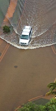
SEBRING - With more than 38 inches of rainfall in the past 55 days, Highlands County and southern Florida water levels are reaching critical stages.
"July will be the fourth month in a row with above-average rainfall," said Gabe Margasak, media relations representative at South Florida Water Management District. "Water levels in ... the water conservation areas are above their target levels. This means there is nowhere for the district to store additional rainfall."
Water is getting into homes. Two weeks ago, two sisters and their boyfriends, "Complete strangers," said Lorraine Russell, who lives on Washington Boulevard east of Lake Placid, came over at 1:30 a.m. and sandbagged around her mobile home for three hours.
That kept water from coming into her garage and back porch, but a few days ago, it began seeping up through the floors in both bedrooms.
"The carpet in both bedrooms are wet," said Russell, a diabetic with an insulin pump. The Red Cross has already put up one family at the Kenilworth Hotel for three days. Now Russell and her friend, a cancer survivor who is still weak from chemotherapy, are moving to a hotel too.
"It just gets worse every time it rains," Russell said. "The Highlands Park Volunteer Fire Department has been pumping water out of my yard. One of their pumps burned out."
Hurricane season began in June, but the season peaks from mid-August to late October, according to the National Oceanic and Atmospheric Administration.
Highlands County Lakes Manager Clell Ford is carefully watching levels.
"We're releasing as much water as we can from Lake June," Ford said on Tuesday, another rainy day. "There's a lot of water coming out of Lake Josephine. We have very high lake levels on Lake Clay and Lake Sebring, and Arbuckle Creek is flowing quite fast and high. Lake Placid is flowing now for the first time since 2006. Lake Placid is letting water flowing out of the culverts. That's a good situation. Lake Jackson came up half a foot in a week."
Jackson and some northern Highlands County lakes aren't full, Ford said. Avon Park hasn't received as much rain as southern parts of the county. Granville Kinsman, manager of the hydrologic data section of Southwest Florida Water Management District, reported that Hicoria, north of Archbold Biological Station, received more than 27 inches, while Avon Park recorded 17.3 inches.
Surprisingly, Ford said, "There are lakes in Avon Park that need rain."
Once again, the waterline is touching many docks at Lake Jackson, a sinkhole which has been one of Highlands County's lowest lakes in the past seven years.
"The most recent level, last Friday, was right at 100 feet above sea level," Ford said. Jackson's recent high level was January 2006, at 102.6, just before a drought began which lasted until Spring 2013.
In June 2008, Jackson sunk to 96.37. "Which is as low as anybody can recall," Ford said.
Now, Ford said, "We're hoping for a day or two of respite."
As it turned out, Wednesday was dry, but a torrential rain hit Highlands County on Thursday morning.
Lake Jackson fluctuated too much for too long, but rising and falling levels are good for a lake's ecosystem, Ford said. During dry seasons, grass grows on the banks and provides hiding places for fish and smaller organisms. "It provides a natural wetland. Lots of organic things are growing. That's important for lake wildlife. When lake levels go up and down, it promotes growth and health and provides the fish a greater variety of places to eat."
Kinsman said Gate 90, the only structure SWFWMD operates in Highlands County, is currently releasing water from Lake June in Winter into Jack Creek, which continues to flow into Lake Josephine, then Lake Istokpoga, then to Lake Okeechobee, then the Everglades and the Atlantic Ocean.
Margasak said the Lower Kissimmee Basin, which includes the eastern border of Highlands County, has seen some of the wettest conditions in the 16-county South Florida Water Management District so far this month and for the wet season to date.
SFWMD is operating flood control pump stations at Lake Istokpoga, discharging basin runoffs from every coastal structure, and coordinating with local drainage districts and governments that operate the network of smaller flood control systems feeding the large regional canals. Engineers and water managers are monitoring real-time conditions 24 hours a day and lowering regional water levels in preparation for the peak of the hurricane season.
Highlands isn't the only wet county in the peninsula. Lemon Bay in Charlotte County has received 26.43 inches, Tiger Bay Slough in DeSoto County has received 27.49 inches, North Port in Sarasota County has received 29.83 inches, and Sulphur Springs in Hillsborough County has received 30.35 inches, Kinsman said.
130725-a
130725-a Phosphorus reductions continue to improve Everglades water quality
SFWMD.gov
(July 25,2013)
Improved farming techniques help EAA, C-139 achieve phosphorus reduction goals.
For the 18th consecutive year, water flowing from farmlands in the Everglades Agricultural Area (EAA) achieved phosphorus reductions that exceeded those required by law.
Implementation of improved farming techniques, known as Best Management Practices (BMPs), produced a 41-percent phosphorus reduction in the 470,000-acre EAA farming region south of Lake Okeechobee for the Water Year 2013 monitoring period (May 1, 2012 - April 30, 2013). Just west of the EAA, the 170,000-acre C-139 Basin also met its goal of reducing phosphorus discharges to historical levels.
"Reducing phosphorus through the technology of Best Management Practices consistently proves to be an effective strategy for improving Everglades water quality," said Daniel O'Keefe, Chairman of the South Florida Water Management District (SFWMD) Governing Board. "These BMPs, working in concert with existing treatment wetlands and the state's Restoration Strategies initiative, are moving us toward the goal of achieving water quality standards for the River of Grass."
The most commonly used BMPs are more precise fertilizer application methods, refined stormwater management practices and erosion controls to reduce the amount of phosphorus transported in stormwater runoff to the Everglades and connected water bodies. Monitoring Documents Nutrient Reductions The BMP program continues to perform extremely well. Farmers in the EAA achieved phosphorus reductions well beyond their target despite challenges including the impact of heavy rainfall in the region from Tropical Storm Isaac.
To meet the requirements of Florida's Everglades Forever Act, the amount of phosphorus leaving the EAA must be 25 percent less than the amount before phosphorus reduction efforts started. The overall average annual reduction from the implementation of BMPs over the program's 18-year history is 55 percent, more than twice the amount required by law. A science-based model is used to compute the reductions and make adjustments to account for the influences of rainfall.
When measured in actual mass, 109 metric tons of phosphorus were prevented from leaving the EAA and entering the regional canal system, which sends water into the Everglades, during the Water Year 2013 monitoring period. Over the past 18 years, the BMP program has prevented 2,673 metric tons of phosphorus from leaving the EAA.
In the C-139 Basin, a BMP program has been in place for the past 10 years. In November 2010, the program requirements were enhanced to better control nutrient runoff. For the Water Year 2013 monitoring period, the target load was 22 metric tons. Data show the actual mass of phosphorus discharged from the basin during that time was 10 metric tons, less than half the target load. Stormwater Treatment Areas Provide Additional Improvements Water leaving the EAA and C-139 Basin receives additional treatment in one of several Stormwater Treatment Areas (STAs) before entering the Everglades. These constructed wetlands are filled with native vegetation and use "green" technology to further reduce phosphorus levels.
Since 1994, the network of five STAs south of Lake Okeechobee - currently with 57,000 acres of effective treatment area - have treated 13.4 million acre-feet of water and retained more than 1,707 metric tons of phosphorus that would have otherwise entered the Everglades. Last year, the STAs treated approximately 1.16 million acre-feet of water, retaining 84 percent of phosphorus from water flowing through the treatment cells.
Through the end of April 2013, more than 4,390 metric tons of phosphorus have been prevented from entering the Everglades through treatment wetlands and the BMP program combined. Overall, Florida has invested more than $1.8 billion to improve Everglades water quality since 1994. Water Quality Improvement Projects Last year, the District completed several water quality improvement projects to further enhance its water-cleaning efforts:
Construction was completed on STA-2 to nearly double its size in western Palm Beach County to 15,500 acres. Known as Compartment B, the 6,817-acre expansion will help the STA achieve optimal performance.
A 4,656-acre expansion of treatment wetlands in southeast Hendry County, known as Compartment C, was completed. Compartment C will further improve water quality flowing into the Everglades. This $47.5 million investment connects two existing Stormwater Treatment Areas (STA-5 and STA-6) in the EAA and more than doubles water treatment capability at the site.
In addition, work has begun under an agreement with the Florida Department of Environmental Protection and the U.S. Environmental Protection Agency (EPA) to expand water quality treatment infrastructure that will lead to achievement of the ambient water quality standard for the Everglades. Key features include:
Design and construction of 110,000 acre-feet of additional storage adjacent to existing Everglades STAs, better controlling water flow into the treatment wetlands and thereby improving their performance. These storage areas, known as Flow Equalization Basins (FEBs), will be designed to assist all five Everglades STAs.
Design and construction of the Stormwater Treatment Area 1 West expansion, increasing by 50 percent the treatment capacity of water quality facilities currently discharging into the Arthur R. Marshall Loxahatchee National Wildlife Refuge.
Additional sub-regional source controls in areas of the eastern EAA where phosphorus levels in runoff have been historically higher, building on the District's existing BMP Regulatory Program. For more information: Improving Water Quality Restoration Strategies for Clean Water for the Everglades BMPs and Source Controls
130725-b
130725-b Scientist says Lake Okeechobee water discharges could be "catastrophic"
WPTV-Ch5 - by: Brian Entin
July 25, 2013
WEST PALM BEACH, Fla. - Anxiety is rising along the fragile network of waterways connected, in one way or the other, to Lake Okeechobee.
Environmentalists looking on today estimate more than four billion gallons of water each day are now pouring out of the big lake,rushing through the Saint Lucie Lock in Martin County. Dr. Tom Van Lent, an Everglades Foundation scientist, said to me, "Disaster is not too strong of a word. It is catastrophic for the health of this river, this estuary."
Lake Okeechobee is swollen by all of our recent rains. Its old, fragile, leaking levee leaves the Army Corp of Engineers no choice but to open the drain, so to speak. That lake water, much of it accumulated from runoff out of the Kissimmee Basin, is filled with phosphorous and nitrogen from agricultural and urban areas. All of that is being dumped into the St. Lucie Estuary.
Van Lent said, "This pollution could trigger large algae blooms. This river (St. Lucie River) could be a fetid, stinking mess in no time at all."
The deluge of polluted freshwater is also harming oyster beds and other marine life. And it also is helping to trigger high bacteria hazard warnings for swimmers along the estuary and Indian River Lagoon. Cody Moral lives in Jensen Beach. He said, "Being fishermen, we see our life going down the drain. We see dead snook, dead snapper, a lot of dead animals floating everywhere."
Long term relief rest with Everglades restoration--including the multi-billion dollar Central Everglades Planning Project, or CEPP. It aims to create a system in which a broad sheet of clean water can someday flow from Lake Okeechobee into the Everglades, as nature intended, thus sparing the estuary much of the runoff.
Everglades Foundation CEO Eric Eikenberg said, "What CEPP does is provide that additional water that is needed in the central system and into Everglades National Park, and it will help the situation we have here today."
There is hope the current water discharges will fast track those restoration plans. Until then a big chunk of the Treasure Coast economy and environment is awash in a rising tide.
130725-c
130725-c Swift action needed on Everglades plan
Sun Sentinel
July 25, 2013
With Florida trying to get in line for money needed to restore the Everglades, a brawl between bureaucracies is threatening to put the 15-year water project on hold.
At its recent monthly meeting, the South Florida Water Management District punted on approving a key Everglades planning project, which is needed to secure federal construction dollars.
It didn't help when a U.S. Corps of Engineers official said that even if the district had approved the plan, the federal agency would have a tough time meeting a critical December deadline for completing its review.
Given that Congress only approves a water bill every seven years, much is at stake in meeting the December deadline.
At risk are five core projects that would restore a large part of the water flow from Lake Okeechobee south through Palm Beach, Broward and Miami-Dade counties into Florida Everglades National Park. The improvements are essential to maintain one of the world's unique ecosystems and one of the nation's largest urban communities.
Gov. Rick Scott should instruct district board members to call a special meeting to approve the planning project before July 31. The governor and Florida's congressional delegation should hold the Corps responsible for a timely review.
The clock is ticking. Swift action is needed now.
130724-a
Water releases
130724-a Beach waters feeling Lake O releases
Fort Myers Beach Observer – by Bob Petcher
July 24, 2013
The salinity level, living organisms (such as plant life, marine animals) and possibly even human respiratory health are all feeling the affects of the recent prolonged Lake Okeechobee releases into the Caloosahatchee River.
Regulating flows from lake and water sheds to river have become a delicate balancing act between scientists and engineers, between protecting estuaries and the overflow of the lake.
Town of Fort Myers Beach Environmental Sciences Coordinator Keith Laakkonen has been monitoring the situation. While releases are year round, the releases have been larger and more frequent during this time of year due to heavy seasonal rains.
"There has been just so much rainfall and, with the release from both the lake and its water sheds, we have had high flows up to 10,000 cubic feet per second," he said.
Laakkonen stated that much scientific research shows that anything higher than 4,500 cu ft/s is harmful to the estuaries.
"It can affect the estuary from driving down the salinity to causing death to oysters, sea crabs and sea grass. It really can upset the delicate fresh/salt water balance the estuaries need," he said. "It's pretty much 100 percent fresh all the way down to the Iona area on the river."
The fresh water releases have affected northern parts of Estero Bay. Laakkonen stated as water comes down the Caloosahatchee, it banks a left and can actually go back under Matanzas Pass and mix far back as Hell Peckney Bay.
"That whole Matanzas Pass area around San Carlos Island is much fresher than it would be naturally at this time of year due to the releases from the lake," he said.
Laakkonen is on weekly conference calls with local scientists, wildlife refuge officials, state senators' office personnel and the Army Corps of Engineers. Those discussions involve updated local estuary conditions, rainfall conditions and weekly and seasonal weather forecasts. Decisions are then made.
"On those phone calls, we do make recommendations and requests. We have been requesting them to use all available storage to reduce these high flows," said Laakkonen. "The water coming out of the lake is very dark colored, which prevents light from being transmitted all the way down to the bottom. That also impacts sea grasses."
If the water is too fresh, fish and other organisms relocate to outer waters.
"These organisms have to move to areas where they can manage salinity balances," he said. "Some may move south, further offshore or seek other parts of the estuary that are not so impacted. When you are losing a big part of your living habitat, you know you are having an impact to the estuary."
Laakkonen said the corps of engineers are concerned about the integrity of the dike around Lake O. Watershed storage space is limited, so some of that has been released as well.
"All that water is being pumped out pretty rapidly. So we are getting very high watershed rain flows and very high lake rain flows," he said. "The problem is that there is no other storage areas to put water during high rainfall events. We've been waiting on the T43 reservoir (part of Everglades restoration project) in the Caloosahatchee watershed for many, many years. If we had some other things in place to hold some of this water back, we would be able to keep some reserve for later in the year when it gets drier."
The brown, brackish color to the bay waters and along the beachfront is a result of the release action. The flows have also brought an abundance of nutrients, which may cause algae blooms. There have been some lingering threats of red drift algae off of Bowditch Point.
"Those are algae that have probably been growing in and around San Carlos Bay and are very responsive to high nutrients," said Laakkonen. "What happens is this algae grows rapidly and, as it grows, it'll break off and drift to shore. It'll take a while fro theses nutrients to get out of the system."
Laakkonen said the Town is monitoring the algae situation very closely. The action appeared to be only on the northern end of the island, but not consistent enough to warrant alarm. Action will be taken if and when the algae moves around to the beachfront.
"The environment is the basis of our economy," he said. "If the estuaries are taking this big of a hit, it has the potential to affect our economy.
Another problem arises when officials from the agricultural areas, specifically the sugar cane fields on the east side of the lake, are back-pumping water into the lake due to flooding issues that have occurred during the heavy rain.
"Everything that could possible go wrong for the lake and the estuary is," said Laakkonen.
Laakkonen said the scientists in Southwest Florida requested more water in the middle of the spring. Natural sea grass beds were recovering and fresh water was needed to continue the recovery process, but the salinity increased with a reduction of flows.
"At that time, they didn't want to give us as much then because they were afraid they wouldn't have enough. Now they have too much, and they are giving us everything at once," he said. "There is so much water coming down that it is blowing out the sea grass in San Carlos Bay and around Ding Darling National Wildlife Refuge. That's the problem with these estuaries. It becomes a very flashy system. It goes from too salty to too fresh. These are major swings that are difficult for the environment to adapt to."
The army corps claims there is very little they can do right now, says Laakkonen.
"One of the things they can do is try to find more storage capacity," he said. "You need places to hold back and bank some of this water so that we don't get these huge fresh water slugs. We are keeping our fingers crossed. We need some drier conditions. Rainfall over the lake and water sheds especially has been a little heavy and intense. That's driving the whole system right now."
Why the lake releases
Laakkonen offered a scientific explanation as to why water is released from lake to river.
"The lake is managed at certain levels at certain times of the year for water supply and also maintaining ecology of the lake and natural systems. If the water gets too high, then there is concern that it could threaten the integrity of the dike around the lake. If that happens, there are concerns that there could be a breach and possibly a flood to some neighboring areas.
Laakkonen said the reason dates back to two strong Florida hurricanes from the 1920s era caused extensive flooding that killed a lot of people around the lake.
"The dike was built in response to that. It has not been reinforced much since it had been built. So, you have a very old levee system and concern that if the water gets too high, the lake could fail and we could have another catastrophic flooding."
130724-b
130724-b Bob Graham supports a new environmental conservation amendment
WUFT-FM - by Alexa Davies
July 24, 2013 Bob Graham wants to make sure there’s an amendment placed on the November 2014 ballot that ensures Florida spends money on land and water conservation, management and restoration.
He and Progress Florida are working with Florida’s Water and Land Legacy Campaign on the amendment to the state constitution.
It would put a third of documentary stamp tax funds into the state budget for the next 20 years, specifically for funding conservation that protects Florida’s remaining ecosystems. There will not be an increase in taxes because funds will come from already-existent tax revenue.
“Critically important in Florida is that our whole economy here is based on tourism,” said Damien Filer, political director for Progress Florida. “So if we don’t have clean beaches for people to come to and have parks and natural spaces, then we don’t have an economy here in our state, either.”
Filer said the campaign is going very well, and if they continue receiving the amount of support they have seen so far, the amendment will be on the Florida 2014 ballot.
If passed, the amendment would go into effect July 1, 2015.
130724-c
130724-c High water levels trigger weekly inspections at Lake Okeechobee's aging earthen dike
Associated Press
July 24, 2013
WEST PALM BEACH, Florida — High water levels have triggered weekly inspections of Lake Okeechobee's aging earthen dike.
Officials with the Army Corps of Engineers say water levels rose above 15.5 feet Monday. That's the benchmark for weekly inspections of the dike that protects surrounding communities from flooding.
Corps spokeswoman Jenn Miller told The Palm Beach Post (http://bit.ly/1dVbOro) that there are no areas of concern along the Herbert Hoover Dike.
Local officials say high water levels increase the risk of the dike failing.
The corps has reinforced a 21-mile stretch of the dike and plans to replace culverts and other structures that have weakened since the dike was built in the 1930s. Rocks and boulders are stockpiled near the lake in the event of a breach.
Lake Okeechobee covers 730 square miles.
130724-d
130724-d Martin County commissioners urge action on lagoon
TCPalm.com
July 24, 2013
Martin County commissioners are urging the public to push for the completion of their Indian River Lagoon South-Project.
The project "was authorized by Congress in 2007 to help address the damaging effects of pollution and unnaturally large freshwater discharges into our ecologically vital water bodies," according to a Martin County Board of County Commissioners news release.
Below is the full text of the release.
As local waterways suffer, Commissioners urge public to advocate for full completion of Indian River Lagoon South-Project
On Saturday the U.S. Army Corps of Engineers increased flows to the estuary to 2810 cubic feet per second (cfs), of which 1377 cfs is from the Lake, and 1433 cfs is from our local basin runoff. With Lake Okeechobee currently at 15.5 feet and rising, it could soon reach a status in which discharges to the St. Lucie Estuary can be "up to maximum capacity". This means our Estuary could soon begin receiving combined runoff and Lake Okeechobee releases of up to 8500 cubic feet per second (cfs).
The Martin County Board of County Commissioners is deeply concerned about the harmful, long-standing impacts these conditions are having on our local waterways. For decades, the Indian River Lagoon and St. Lucie Estuary have long suffered from altered water flow patterns and degraded water quality.
Dark water can now be seen outside the St. Lucie Inlet, extending south to Jupiter Island. Unprecedented levels of bacteria in our local waters have resulted in posted "no swimming" areas. Low salinity levels from the freshwater releases are killing oysters and seagrasses. The problem is extensive, as are the needed solutions.
"Given current forecasts and projections, our situation is expected to worsen," said Commissioner Sarah Heard, Chair of the Martin County Board of Commissioners. "It is more important than ever to move forward with solutions, including completion of the Indian River Lagoon-South (IRL-S) Everglades restoration project."
The Indian River Lagoon-South (IRL-S) Restoration Project, a component of the Comprehensive Everglades Restoration Plan (CERP) was authorized by Congress in 2007 to help address the damaging effects of pollution and unnaturally large freshwater discharges into our ecologically vital water bodies.
Components of the IRL-S project will improve runoff management in local basins. The project is expected to provide significant water quality improvements to both the IRL and the St. Lucie Estuary by reducing the load of nutrients, pesticides, and suspended materials from basin runoff.
The C-44 and Stormwater Treatment Area component of the IRL-S project is currently in the first phase of construction in western Martin County. Federal funding for the second phase is needed to keep the project on schedule without delays.
Martin County is working with our Congressional Delegation and U.S. Army Corps of Engineers to secure the needed funds to get the C-44 project back on track and encourages residents to write letters in support of the project.
The Indian River Lagoon and St. Lucie Estuary in Martin County are two of the country's most productive and most threatened estuaries. Home to more than 4,300 species of plants and animals, and supporting an annual economic contribution of more than $730 million, the lagoon region will benefit from careful restoration and protection of these water bodies.
Community sentiment is rightfully strong against the environmental degradation which is occurring. Residents are signing petitions, protesting, and writing letters voicing their concerns about the crisis affecting our local waterways.
Components of the IRL-S will assist our community in mitigating some of the impacts our Estuary has historically received We urge the community to assist us in advocating for full completion of all components of the IRL-S project and other needed solutions.
Looking to get involved ? Our "Speak Up for the St. Lucie" campaign is growing, with nearly 2,000 "likes" on Facebook. Sign up for our e-mail action list or "like" our Facebook page. More information is available at www.martin.fl.us under Hot Topics/Speak Up for the St. Lucie. Here you will find sample letters to federal officials, updated news, photos, and other resources.
130724-e
130724-e On the Water: Release from Lake Okeechobee continues
Pine Island Eagle – by Capt. Bill Russell
July 24, 2013
As rainy days continued across south Florida, the Army Corps of Engineers continued to dump large amounts of unwanted fresh water our way. The state is releasing a very high amount of water from Lake Okeechobee through the Caloosahatchee River with the final destination in our back yard. As mentioned last week, it's too early to know what, or how much damage it will cause but as the week progressed you could visually see our inshore waters becoming darker and dirtier. Some anglers report really tough fishing in their favorite inshore holes while others found fishing decent to good.
With the big moon we had very high water and strong tide flow most days, a good combination for redfish. Most redfish reported were caught in northern Pine Island Sound, Matlacha Pass and across the harbor in Bull and Turtle bays. The reds were taken on a variety of natural baits including pinfish (live or cut in half), shrimp, cut ladyfish and larger thread herrings cut in half. The best bite came at the top of the tide around oyster bars and mangrove shorelines, and in adjacent potholes on the lower stages. The reds ranged in size from a small of 16 inches up to 33 inches. A few snook including a 30 incher, plus several big trout were also caught around oyster bars according to Capt. Cliff Simer.
Small to medium tarpon were sighted or hooked in northern Pine Island Sound and Matlacha Pass. A good number of fish looking to weigh from 20 to 60 pounds were sighted rolling around the Matlacha drawbridge following afternoon rains, and tarpon in the same size were spotted rolling or hooked near Cabbage Key while targeting trout. Larger tarpon were found in small pods a mile or less from the beach of northern Cayo Costa.
Mackerel and bluefish were caught in Charlotte Harbor but the bite was much slower than the previous week.
The water is way too dark to visually tell grass from sand bottom over the deeper flats, if you have a spot memorized or marked the better bet is to try it first. There are some big blacktips prowling the deeper flats, we hooked two and landed one going between 5 and 6 feet on a live ladyfish near the northern end of Bokeelia. Also, don't be surprised if you hook a big gar fish - yes, a freshwater gar fish, with all the fresh water being flushed they are becoming common in our waters.
Beach anglers on Sanibel found the water extremely stirred up and dirty making it near impossible to sight fish snook or other species along the surf. The clarity is better the further north you go with decent visibility from Redfish Pass north. Several sharks and one large sawfish were also caught and released from the beaches during late evening near Blind Pass. Snook were also caught and released near the bridge on Blind Pass.
Offshore, red and gag grouper were hooked from 40-foot depths out past 100. Several gags up to 30 inches were caught trolling big deep diving lures between 40 and 60 feet, west of Captiva. Out deeper, a mix of reds and gags were caught on various structure, often the best bet was to quickly fish an area and move on if no results. For this style fishing, a large live pinfish on a heavy white jig bounced over the bottom is hard to beat. Schools of Spanish mackerel were located 8 to 12 miles west of Boca Grande. Watching for birds and surface feeding and trolling silver spoons through the area gave the best results.
As fresh water continues to discharge into our bays and estuaries, we need to keep our fingers crossed that the damage to our marine life will be minimal. I have watched before as our lush grass beds were completely wiped out for several years following this same scenario.
I have heard for years and years that a solution is coming soon to prevent these huge dumps of fresh water, let's hope something will be done before the damage is irreversible. If you have a fishing report or for charter information, please contact us at 239-283-7960; on the website at www.fishpineisland.com; or via email: at gcl2-fish@live.com
Have a safe week and good fishin'.
130724-f
130724-f Professor introduces the hazards of environmental traps
FIUSM - Jessica Valeria Rodriguez/Staff Writer
July 24, 2013
Most people are aware that by cutting a tree we are taking away a bird’s home; this is one of many commonly known destructions created by humans. Jennifer Schopf Rehage, Assistant Professor in the Department of Earth and Environment, recently co-authored an article about a new way that we are causing harm to animals that needs to end.
The phenomenon is called environmental traps, which are traps we place when we take over habitats and bring in new factors like species that don’t belong there or taking their food. This causes the native animals to settle for worse food, mates and habitats that prevent them from undergoing natural selection of the best of each species.
Rehage explains that organisms are accustomed to making decisions based on what they think looks good; they have yet to realize that some things are human-induced and won’t help them. If they don’t learn how to differentiate quickly, it could lead to population declines. Multiple animals will be affected, including mammals, birds, amphibians, fishes, reptiles and insects. She also encourages for something to be done about these traps as they have a possible fix and are not very difficult to tackle. We merely need to change our ways so that animals can tell the difference between a Christmas light decoration and dinner.
In her faculty page, Rehage states, “I am an aquatic ecologist and my research interests are focused on the study of how anthropogenic disturbance alters the nature of key ecological processes and mechanisms.” Rehage has a bachelor’s degree in environmental studies from FIU and a Ph.D. in ecology, evolution and behavior from the University of Kentucky.
Junior biology major Carlos Nogues has shown interest in Rehage’s class and plans to take it in the fall. “Her work is very interesting. Evolutionary traps are becoming a problem, especially in our area where invasive species are damaging the Everglades.”
Nougues shares this interest with his younger sister, sophomore public relations major Karina Nougues. “I’m not an expert on science, but her study makes a lot of sense. Instead of trying to fix global warming, we should focus on fixing these traps because they are more doable tasks,” she said.
The paper was published in the scientific journal “Trends in Ecology and Evolution” last month. It is the first to provide a comprehensive review and present a framework for predicting the defenselessness of an organism to being trapped. If you are interested in reading the article, it is titled “Ecological novelty and the emergence of evolutionary traps.”
130723-a
130723- Environmental groups rip federal proposal on regulating water pollution from coal plants
Florida Current – by Bruce Ritchie
July 23, 2013
A coalition of environmental groups says stronger federal regulations are needed to protect waterways and fish from discharges from coal-fired power plants including 14 with discharge permits in Florida.
At least seven plants expel heavy metals into the waters of Florida, according to the groups. No plant in Florida, they say, has permit limits on all of the toxic metals of concern such as arsenic, boron, cadmium, mercury and selenium.
Of the 274 coal plants nationwide that were reviewed in the coalition's report, nearly 70 percent have no limits on those toxics dumped into waterways, the report said. And nearly half were operating with an expired permit.
Although the report was directed at the U.S. Environmental Protection Agency, Bradley Marshall of the Earthjustice law firm said Florida could do more on its own.
"They (state officials) can set stricter limits or make sure there are limits on all the toxic metals these coal plants produce and put in our waters," said Marshall, a lawyer in the firm's Tallahassee office.
A Florida Department of Environmental Protection spokesman said the department didn't have time to review the report.
The department reviews permit applications based on Florida rules and statutes to uphold "stringent" environmental standards, spokesman Patrick Gillespie said.
The department issues pollution limits based on the results of sampling and the characteristics of the nearby water bodies, he said. Monitoring is done monthly or quarterly and routine inspections are conducted in order to ensure compliance.
The federal EPA is considering options for setting stricter pollution limits, but the environmental groups say those options would provide little or no protection.
In response, a federal EPA spokeswoman said the agency has identified four options that would reduce pollution discharges by 470 million pounds annually to 2.6 billion pounds. The EPA is requesting comments on the proposal through Sept. 20 and faces a May 22 court deadline to take action.
A news release from environmental groups identified Alligator Bayou as being polluted from discharges by Gulf Power Co.'s Lansing Smith generating plant in Southport.
Gulf Power spokesman Jeff Rogers said Alligator Bayou is an intake source for cooling water, not a discharge point. The utility, he said, is in compliance with Florida water quality standards.
According to the environmental groups' report, Duke Energy is regulated for arsenic, cadmium, mercury, lead and selenium in wastewater at its Crystal River coal plant, which is slated to be closed by 2018. A Duke spokeswoman said there are no coal ash discharges there except during heavy rain events, otherwise they discharge only non-coal cooling water.
This year, the Legislature passed SB 682, which defines beneficial uses of coal ash in Florida. The legislation was filed in response to the EPA considering separate regulations on the handling of coal ash waste.
The U.S. House of Representatives is scheduled to vote this week on legislation to create a state-based regulatory framework for handling coal ash that Republican leaders say will create jobs. The Florida Electric Cooperatives Association Inc. has signed a statement in support of the federal legislation, according to the House Committee on Energy and Commerce. Related Research: * July 23, 2013 Environmental groups' news release with link to report
* July 23, 2013 U.S. House Committee on Energy and Commerce news release on coal ash legislation
* July 12, 2013 Link to EPA proposed regulations on water discharges from coal plants
130723-b
These hairs allow
manatees to detect
water movement more
keenly than any other
marine mammal tested
to date
130723-b Mote study reveals new info on manatees
Bradenton Times - by Mote Marine Laboratory
July 23, 2013
SARASOTA — Manatees can feel water movements thousands of times smaller than the width of a human hair — an ability that makes them one of the most touch-sensitive mammals on Earth — according to a new study led by scientists at Mote Marine Laboratory.
The study, published recently in a special issue of the peer-reviewed Journal of Comparative Physiology A, is the first published research revealing how well manatees can feel water movement using their facial whiskers. Results show that manatees can detect tiny ripples better than any marine mammal studied to date, suggesting that touch may be vital to their survival in the wild.
The study tested the touch sensitivity of Mote’s resident manatees, Buffett and Hugh — the most extensively trained manatees in the world. The manatees participate voluntarily in training sessions for husbandry (animal care) procedures along with research.
For more than 15 years, Mote research has focused on how manatees use their senses to perceive their ever-changing environment. Florida manatees (Trichechus manatus latirostris) are an endangered species facing threats such as habitat loss, severe cold stress during winter, harmful algal blooms, entanglement in marine debris and boat strikes. Understanding their senses can help reveal how manatees perceive and possibly avoid risks.
Mote studies have already shown that manatees’ vision is poor, compounded by the turbid and tannic waters where they spend much of their lives, that manatees can hear a wide range of pitches despite loud background noise and can detect which direction sounds come from. Research at Mote has also revealed that manatees can feel textures as keenly or better than a human Braille reader by using their sensitive facial whiskers, known as vibrissae.
The new study aimed to reveal how well these facial vibrissae detect water movement — possibly one of the most important signals for navigating and avoiding nearby obstacles.
“We know that touch is important to manatees — their vibrissae are linked with many sensitive receptors and a large portion of their brain is dedicated to touch — but to really know how this translates to their behavior underwater, we needed to put their senses to the test,” said Dr. Joseph Gaspard III, Mote’s Manager of Animal Care, Training and Research.
The study was led by Mote scientists in Sarasota, Fla. in collaboration with the University of Florida College of Veterinary Medicine in Gainesville, New College of Florida in Sarasota and University of South Florida College of Marine Science in St. Petersburg.
Research took place at Mote’s public outreach and informal science education facility, The Aquarium, where Buffett and Hugh can be viewed by the public daily and where they participate in morning research sessions behind the scenes. This unique research and training program was pioneered by scientists from Mote and New College.
“Through their extensive training, Hugh and Buffett are able to tell us how well they can sense water movement,” Gaspard said. “We send out a signal which is essentially a 3D ripple, and then we ask them, ‘Did you feel that?’”
During each research trial, a manatee positions its snout against a bar and waits. Then a scientific instrument nearby creates the ripple with a vibrating ball, or it stays still. When the manatees feel the water movement, they are trained to touch a yellow paddle, and when they feel no movement, they are to stay put. Each time a manatee responds correctly, it is rewarded with tasty apples, beets, carrots or monkey biscuits – all part of their structured healthy and balanced diet
The manatees tried their whiskers at harder and harder tests, in which the vibrating ball generated less intense waves — causing less water movement — and made fewer movements per second — a lower frequency. By lowering the vibration in the water and documenting how often the manatees got the answer correct, the researchers found the manatees’ threshold values — the lower limits of what their facial whiskers could detect.
When water rippled at 150 Hertz (times per second), Buffett and Hugh could feel water movement around and below one nanometer, respectively. For comparison, a human hair measures 80,000-100,000 nanometers wide. When the scientists lowered the ripple to 10 Hz, the manatees could detect water movements of 1,000 nanometers — still much smaller than a hair’s width.
“The manatees had remarkable sensitivity,” Gaspard said. “In touch research with marine mammals, the closest score we know of was from harbor seals, and the manatees blew them out of the water. They were more than 10 times more sensitive.”
Manatees may use their super sense of touch to feel small changes in the relatively calm waters where they live and feed, to sense the “boundary layer” of water around obstacles and to feel which way currents are flowing — possibly an aid to migration, Gaspard said.
New research in progress is testing how Hugh and Buffett use the sensitive hairs along their bodies, not just their faces, to feel water movement. The researchers suspect that manatees might use touch to form a 3D map of their environment.
The researchers also suspect that touch helps manatees detect nearby objects, while hearing is useful over longer distances. They hope to apply this knowledge to study how manatees react to boats in the wild.
Said Gaspard: “Touch may not help them detect a distant watercraft, but if the boat is moving slowly enough, the water movement might just give the manatees a final burst of information that helps save their lives.”
Mote staff have special permits to work with manatees, along with years of experience. In the wild, you should observe marine mammals from a distance and never interrupt their natural behaviors or give them food or water.
130723-c
130723-c New report shows seven coal-fired power plants in Florida discharge toxic coal ash or wastewater, highlighting critical need for strong federal standards
SierraClubFloridaNews.org
July 23, 2013
ST. PETERSBURG, FL -- Today, a coalition of environmental and clean water groups, including the Sierra Club, Earthjustice and Clean Water Action, released a new report demonstrating the importance of strong U.S. Environmental Protection Agency (EPA) standards that limit toxic water pollution from coal plants for Florida. The report, “Closing the Floodgates: How the Coal Industry Is Poisoning Our Water and How We Can Stop It” reviewed water permits for 386 coal plants across the country, and sought to identify whether states have upheld the Clean Water Act by effectively protecting families from toxic water pollution.
As the analysis relates to Florida:
At least seven plants discharge heavy metals into the waters of Florida. No plant in Florida has permit limits on all of the toxic metals of concern, such as arsenic, boron, cadmium, mercury, and selenium.
Rice Creek has become an impaired waterway because of pollution from the Seminole Generating Station in Putnam County. Now, instead of addressing concerns about toxic metals in its discharge, the Seminole Generating Station directly discharges into the St. Johns River.
Alligator Bayou is impaired by pollution coming from Gulf Power’s Lansing Smith coal plant, which dumps mercury and arsenic without limits.
Florida does not ensure that the permit limits it does have are stringent enough to protect our water.
“This report makes it clear that Florida utilities need a lesson in common sense: dumping poisons into our water without disclosing threatens health, drinking water and recreation opportunities,” said Julia Hathaway, Florida Sierra Club Beyond Coal organizer. “Environmental Protection Agency limits on these toxics in our water will prevent children from getting sick and save lives.”
Existing guidelines written to limit toxics discharged from coal plants do not cover many of the worst pollutants such as in 2011 when the Big Bend Power Station in Hillsborough County discharged 1206 lbs of selenium into the Big Bend Bayou. These guidelines have not been updated in 30 years. In April 2013 the Environmental Protection Agency proposed the first ever national standards for toxics dumped into waterways from coal plants.
The Sierra Club’s Florida Beyond Coal campaign and Clean Water Action are organizing to support the strongest options for these “effluent limitation guidelines” that will limit the amount of toxic chemicals that are dumped into our waterways. These standards will also require all coal plants to monitor and report the amount of toxics dumped into our water, giving us detailed information for the first time about the types and amounts of dangerous chemicals in our water.
“Limiting the amount of toxics in our water through commonsense standards will strengthen our economy, protect our health, and ensure our water is safe to drink and our fish are safe to eat,” said Kathleen Aterno, Florida Director of Clean Water Action.
“There is technology available to keep toxins from coal plants out of our water, and we should simply insist that these corporations use it,” added Bradley Marshall, attorney with Earthjustice.
The new report’s nationwide findings were similarly shocking:
Of the 274 coal plants that discharge coal ash and scrubber wastewater into waterways, nearly 70 percent (188) have no limits on the amounts of toxic metals like arsenic, boron, cadmium, mercury, and selenium they are allowed to dump into public waters.
Of these 274 coal plants, more than one-third (102) have no requirements to monitor or report discharges of toxic metals like arsenic, boron, cadmium, mercury, and selenium to federal authorities.
A total of 71 coal plants discharge toxic water pollution into waterways that have already been declared as impaired. Of these plants that are dumping toxic metals into impaired waterways, nearly three out of four coal plants (59) had no permit that limited the amount of toxic metals it could dump.
More than half of the coal plants surveyed (187) are operating with an expired Clean Water Act permit. 53 of these power plants are operating with permits that expired five or more years ago.
The new report also reviewed red-line copies of the EPA’s proposed coal plant water pollution standards or “effluent limitation guidelines” obtained through Freedom of Information Act requests, finding that the White House’s Office of Management and Budget (OMB) caved to coal industry pressure and took the highly unusual and improper step of writing new weak options into the draft guidelines prepared by the EPA’s expert staff. The seven coal plants include:
Tampa Electric Company's Big Bend plant in Hillsborough County
Gulf Power Company's Crist electric generating plant in Escambia County
Gulf Power Company's Lansing Smith generating plant in Bay County
Tampa Electric Company's Polk plant in Polk County
Gulf Power Company's Scholz Electric generating plant in Jackson County
Seminole Electric Cooperative's Seminole plant in Putnam County
Jacksonville Electric Authority's St. Johns River power plant in Duval County
A chance to guarantee water and land protection.
There was a time when protecting and preserving Florida's natural treasures was a proud piece of our state's public policy. Governors, legislative leaders and everyday Floridians all joined to support an Preservation 2000, to ensure that the woods and waters that make Florida so special would be around for generations.
Then the Great Recession hit, and Gov. Rick Scott took office, and the stewardship of Florida's environment suddenly was deemed a budgetary inconvenience. Between 2009 and 2011, in addition to the dismantling of the Department of Community Affairs and the slashing of water management budgets, spending for the landmark Florida Forever program alone was cut a shocking 97 percent, with a paltry $23 million spent between 2009 and 2013. Even this year, when the Legislature and Scott approved $75 million for conservation funding, $50 million was required to come from the sale of existing state lands.
Florida needs a stable source of funding to protect its most precious resources. These resources are not just environmental jewels, but economic drivers as well. Tourism is Florida's No. 1 industry, and it cannot remain that way if our beachfronts are polluted, our woods are decimated, our lakes and rivers are turning green and losing fish populations.
The Florida Water and Land Legacy Campaign -- a coalition of some 300 groups led by Audubon Florida, the Florida Wildlife Federation, the Sierra Club, the Nature Conservancy, 1000 Friends of Florida and the Trust for Public Land -- is conducting a petition drive to place a constitutional amendment on the November 2014 ballot that would go a long way toward saving our diminishing environment.
Known as the Water and Land Conservation Amendment, it would require no new taxes but rather would require one-third of the documentary tax paid on real estate transactions be set aside for conservation land purchases, protecting drinking water sources and encouraging fish and wildlife programs, as well as other environmental stewardship efforts.
Think the Everglades and Silver Springs, for starters.
If the amendment passes -- and history shows that Floridians get the importance of such investment in our state -- supporters estimate about $10 billion would be generated over the 20-year life of the amendment, which would sunset by law in 2035.
What the amendment would specifically do is prohibit the Legislature from making an annual money grab of dollars set aside for environmental conservation and preservation programs. The Legislature has made this such a habitual practice that it has lost sight of the importance of our natural treasures in the process.
So far, proponents have collected hundreds of thousands of petition signatures toward the 683,000 necessary to get it on the 2014 ballot. Recently, they reported needing another 150,000 signatures by the Nov. 30 deadline.
We encourage all Floridians to join the fight to stem the slow destruction of Florida's rich environmental heritage by supporting the Water and Land Conservation Amendment. To sign the petition, go online to www.FloridaWaterLandLegacy.org.
This is a chance to do something good for Florida. It deserves every Floridian's enthusiastic backing. This editorial was published in the Ocala Star-Banner, a fellow member of the Halifax Media Group.
130722-b
Sonny VERGARA
130722-b Four questions for Sonny Vergara
WateryFoundation.com
July 22, 2013 Emilio (Sonny) Vergara is the only person who has served as Executive Director of two Florida Water Management Districts (St. Johns River and Southwest Florida) and a Regional Water Supply Authority (Peace River/Manasota). He is active in the Florida Conservation Coalition and maintains the hard-hitting SWFWMD Matters blog. Below, Sonny takes on four key water management questions I posed to him: Q1. What should be the key goals of Florida water management ?
Before trying to answer directly, some historical context …
To begin with, the question might be best answered by Herschel Vinyard and Jeff Littlejohn since they developed a public relations blitz based on getting districts “back” to their “core mission.” Using the word back suggests they believe the districts have gone astray from what they were supposed to be doing over the last five decades and these two fellows somehow know better than anyone what the districts should have been doing but weren’t. Getting the districts “back” (to somewhere) has since become their rallying cry for fundamentally changing them from what earlier Governors and legislatures have been directing them to do for the last 50 years. It is becoming clear now that getting the districts back to their “core mission” was nothing but a subterfuge to allow Tallahassee to begin an immediate transformation process that has lasted three years now and has gone far beyond any reductions that might have been appropriate to reflect a struggling national economy. While perhaps legitimate – sounding on the surface, it became clear that a much less legitimate intention was at hand.
Plainly put, their true intent was to clear the way for big business (agriculture, power, mining, land development and – in short – the members of the Florida Chamber of Commerce and Florida Land Council) to be able to avoid having to deal with distracting and worrisome environmental and growth management regulations. When this became apparent to certain well-heeled private sector parties, it released a pent up feeding frenzy by Tallahassee lobbyists to take as much advantage of the situation as possible and see how much “reduction” they could do to environmental and growth management regulations as well.
The administration’s plan was first to stop, de-authorize and, in some cases, simply disregard environmental and growth management regulations at every opportunity. Then, the agencies themselves were to be dismantled and weakened by defunding their revenue sources and shredding their regulatory staffs to the point they now have very little capacity to function as they should. Today, remaining agency scientists and staffers work in abject fear of their Tallahassee-installed supervisors and of losing their jobs in embarrassing ways, like how a very unprofessional reduction in force was carried out at the direction of Jeff Littlejohn and Herschel Vineyard at the Tampa office of DEP.
Vinyard and Littlejohn are now forging new regulatory policies by letting regulated, private -sector entities write them. If that concept isn’t bothersome enough, such actions are not only inappropriate but very likely illegal. Chapter 120, F.S, requires that before implementing a policy with significant implications a regulatory agency must follow certain procedures, which include vetting the proposed policy’s potential impacts with the affected public and using rule adoption protocols to institute them. The Highlands Ranch Mitigation Bank permit offers a case in point where a policy fundamental to all environmental permitting in Florida was simply replaced on the fly and implemented by DEP deputy secretary, Jeff Littlejohn. It was done with the only public input coming from the applicant’s attorney. The existing policy, known as “reasonable assurance,” was declared inoperative and the new policy was immediately instated. Certainly, any policy that will set the standard for complex and important public interest matters such as the safe and effective management of the state’s water resources and the unique natural systems that depend upon them, should be subjected to the procedures prescribed by Chapter 120.
So, the claim that the districts needed to get back their core mission was essentially the new administration’s version of a Trojan Horse. Saying changes were needed to reflect the state’s declining economy, while sounding reasonable, was actually nothing more than a disingenuous ruse to hide the real transformation they were pursuing which was to dismantle Florida’s carefully evolved environmental and growth protections to the maximum extent possible.
Historically, the statutory goals of the districts have morphed substantially from their primary focus on, for example, flood control. There is no question about this. The reasons for it, however, are obvious and sound. Legislators and governors from both parties found it necessary to assign additional duties to the districts over the years because of the expanding needs of a growing population and a changing society that was demanding it. The reason this was believed to be the way to go was that the state could not afford the cost but the districts could, so it was delegated to them.
For one significant example, an unfunded mandate that had enormous impact on the districts’ budgets and taxing levels resulted from passage of the Warren S. Henderson Wetlands Protection Act of 1984. This act required DEP to begin regulating all dredge and fill operations. The responsibility for implementing this new responsibility was quickly delegated to the districts, however, because elected state officials simply were not going to take the heat that would be generated by raising the taxes necessary to pay for it.
Today we know that limiting regulation of pollution, flooding, water use, loss of wetlands, wildlife, wildlife habitat, recharge lands, and shorelines, simply because it might affect the state’s economy to some degree, will not lead to any long-term prosperity for the state. We are realizing that absolute limits need to be set because, in the end, not setting them will result in irreparable harm to the state’s physical and economic well being. In other words, we now have to draw clear and absolute lines in the sand. Setting Minimum Flows and Levels and Total Maximum Daily Load limits are two examples where the attempts to achieve this are already underway. It is endgame thinking. If founded upon good science and wise policy, allowing maximum or minimum limits to be exceeded could cause negative impacts from which recovery might not be impossible, could be very long–term, very expensive, or all the above.
Therefore, I suggest the key goal of water management should be to have their authority, autonomy, and funding capacity returned at least to where it was before 2010. Urbanization of the state has not stopped and everyday it continues the attendant resource problems grow more complex and solving them gets more expensive. It is ridiculous to think that the key to the future is to create a weaker, more highly politicized, less science-driven, less experienced, Tallahassee-controlled resource management agency to replace what was in place before 2010. As urbanization continues to threaten those aspects of natural Florida that, if destroyed, will have a devastating impact on its economic future, it is frightening to think what has become of the country’s most respected water management system. It has become only a flimsy, filmy rendition of what it was and it will not be able to do the job. Changes must be made.
More specifically, some goals for water management should include:
Remain as autonomous as possible from Tallahassee political interference. The governor’s oversight and appointment authority is appropriate and adequate. The legislature can initiate further direction by proposing and vetting laws needed to keep the districts’ abilities to solve problems in line with ever-changing statutory charges and priorities. Governing board members are not incapable and should not have been completely marginalized as they have. The way it is today, with all decisions being made in Tallahassee, there’s hardly any reason for them to continue to exist.
Return control of the districts’ constitutionally authorized ad valorem taxing authority to the governing boards. In 2010 and 2011, most of it was taken from them by the legislature and the governor’s office. Florida’s constitution prohibits property taxes levied at the state level. The current level of legislative and gubernatorial control of district budgets may be encroaching upon that prohibition. Governing boards were created to identify and prioritize resource problems and determine the funding needed to resolve them at the regional (non-state) level. Today, however, any legislator who is friendly with an applicant can bring pressure upon a district’s regulatory decision-making processes. Lobbyists and their regulated clients are having a field day. Also, while DEP has supervisory duties over the districts by statute, it was never intended that the secretary of the department should dictate what they are to do, how they are do it, or try to influence the issuance of permits - all of which appears is to be happening today. Governing board members know the problems within their districts and they know they will be among those paying the taxes levied to fix them. They should be able to generate their own budgets within reasonable millage caps set by the legislature, determine the optimum staffing levels needed to achieve their priorities, and hire their own executive director – none of which is happening today.
The idea that Florida’s water resources should be somehow made available to the private sector to sell to the highest bidder needs to be ended once and for all. Recent covert attempts (City of Tampa; 2012; HB639; Dana Young) to become owners of water and be able to place a value on it beyond what it costs to develop, treat and transport it, should be halted. While privatizing water might sound reasonable in some contexts, the bottom line is that its price will be market-driven and those who need it the most will have to pay the most. In this kind of world, price control through competition will not work as public supplies become very limited and only a few control them. Privatizing water supplies and selling it as a commodity will only create great wealth for a few at the expense of virtually the entire population of Florida, because every member of it must have it.
Remove the dollar caps placed upon the districts’ budgets and leave their ability to meet their statutory obligations alone. Governing board members are appointed by the governor who has adequate oversight to keep district budgets in check. The limits the legislature set on the abilities of the governing boards to support a budget capable of addressing known resource problems is preventing them from effectively carrying out their statutory duties.
Modify the millage caps set by the legislature in 2010 and 2011 back to what they were before.
Priorities for water management: a) Return science as the basis for regulatory and resource management decisions instead of political doctrine or influence. Science is no longer a primary consideration in the issuance of a permit as exemplified by: the Highlands Ranch Mitigation Bank permit; no-bid leases to specific entities being dictated by the legislature; the continuing inability to stop additional withdrawals or pollution within the springsheds of major springs despite the obvious damage, and; the fact that the issuance of permits is routinely influenced by Tallahassee. b) Co-partner with local governments on projects that are consistent with statutory directives and do not create conflicts of interest with the districts’ regulatory responsibilities. Limit co-funding for local projects to the ad valorem taxes paid by those who will benefit from the project. Establish a pathway for local input on projects to be undertaken and who is going to pay for them. This was standard protocol in SWFWMD before its basin boards were eliminated and their governor-appointed members fired by the new Scott administration. c. Aggressively continue setting absolute limitations designed to prevent damaging over-withdrawals from identified water bodies. Good science and sound policies must be followed. Politicizing the development of policies and its supporting science will only result in ineffective or dangerous decisions that can cause terrible mistakes and irreversible damage. d) Aggressively continue setting absolute limitations designed to prevent identified water bodies from damaging pollution levels from point and non-point pollution sources. But to restate, politicizing the process will only poison the credibility of the limits and their projected effectiveness. e) Continue the acquisition of conservation lands, which has been functionally halted for the last three legislative sessions. Acquisition of conservation lands is vital to the state’s future. If significant funding ever again becomes available, public ownership in fee title should be the primary objective. The current thinking is that ownership of conservation easements without ownership of the property is just as effective. In the long term, it is not. This should be resisted. Any belief that acquisition of conservation easements is going to permanently preserve and protect natural Florida in perpetuity to the same extent as the public actually owning the property, is not valid. In some cases, it may be the only alternative available to reach a conservation goal, but placing land in public ownership is always the better alternative. Many times the cost of an easement is very near the actual market value of the land. The purchase of certain rights vs. fee title becomes a windfall for the seller. Conservation easements rarely sufficiently constrain the current uses of the landowners who remain in total control of the property Usually, conservation rights preclude public rights of entry. This is not a bargain that serves the public’s best interests. f) Aggressively continue to develop and require conservation of water. Reduction of demand through conservation and reuse is going to be the only available answer for meeting the future water supply needs of many communities that have no other viable alternative. Carry out and support efforts to research and develop cost effective alternative processes to treat water to drinking water standards. Avoid perpetually supplementing the cost of developing, treating and distributing water. Real and actual cost will be higher but it can substantially reduce per capita consumption by causing needed changes in water use behavior. This is not to preclude partnering by the districts with local entities on a one-time basis in order to incentivize their decision to use a process that has greater environmental value. g) Carry out water supply planning and water resource management based upon surface and groundwater basins. Planning should be based on the ability of a basin’s resources to support the plan. Avoid inter-basin transfers that only serve the future of one community at the expense of another. This is neither good planning nor good government. h) All policies and regulations should be aimed at protecting and preserving what’s left of Florida’s natural hydrologic and biologic systems. i) Be leaders in resource monitoring (data gathering) and development of the sciences (research) needed to make informed water resource management decisions. j) Maintain a vigorous public education and information program and solicit the support of a constantly changing population’s participation in the most effective water use practices. The current thinking in Tallahassee is that “outreach” is inappropriate agency promotion. In reality, it is a valuable strategy used to educate and obtain public support and participation in achieving water resource management objectives. For example, reducing per capita usage by an informed and motivated public from 120 gallons per day to 100 gallons per day for the population of Tampa Bay (which let’s assume is 4 million) would free up 80 million gallons every day to meet the demands of future growth and natural systems. Public education through water management outreach has been seriously misunderstood by the current administration. Outreach became one of the most targeted district activities for reduction by Tallahassee because it was considered unnecessary. k) Reinstitute a quality growth management function for Florida and join it at the hip with comprehensive water resource planning. Presently, the result of the legislature’s dismantling of the state’s primary planning agency, the Department of Community Affairs, has been to deny the state the ability to set a clear course for managing growth in the future. It is a state where Tallahassee leaders have essentially washed their hands of the responsibility and set it adrift with no apparent concern that 67 individual and separate county commissions are now in charge of its future. It is almost laughable, were not so idiotic, that Florida, the country’s fourth most populated state, has decided that having and following a master plan for its future growth was unnecessary. It is ridiculous, and it should be embarrassing within all of our highest elected offices. l) Be as frugal and effective as possible but avoid indiscriminant across the board budget cuts which can hinder resource management capabilities. Cut only where appropriate and consistent with the district’s responsibilities and priorities. Q2. What is the biggest Florida water problem ?
The biggest Florida water problem today is the fact that the capacities of the districts have been curtailed to the point that they can no longer successfully and effectively achieve their many responsibilities. They are underfunded and understaffed, which will give the legislature a perfect opportunity to declare them Passé and attempt to replace them with institutions of completely different responsibilities, authorities and funding sources The objective being, to replace them with new institutions that cannot and will not be as effective as what the state had before 2010. This situation is the result of vast ignorance finding itself in positions of great power with no knowledge of what needs doing or how to go about doing it, and having to rely on those who do know but who are guided only by short term, self-serving purposes and could not care less about Florida’s long term future.
The biggest problem tomorrow, is obtaining enough sustainable and affordable water to meet the state’s future demands and still maintain healthy natural ecosystems consisting of adequate and clean flows for sustaining natural water bodies and the natural biological systems that depend upon them. Q3. What aspects of water management have gotten worst ?
Frankly, I can’t think of one aspect of water management in Florida that hasn’t worst. The scenarios depicted above pretty well describe what and why. Q4. What aspects of Florida water management have gotten better ?
Frankly, I can’t think of one that has. The scenarios depicted above pretty well describe what and why.
130722-c
130722-c Gov. Scott: Many decisions on Lake O release out of his control
TCPalm - by staff
July 22, 2013
PORT ST. LUCIE — Gov. Rick Scott cautioned Monday that many decisions leading to harmful Lake Okeechobee freshwater releases into local waterways are out of his control.
Following an economic roundtable of St. Lucie County business leaders, Scott mentioned few specifics about addressing freshwater lake pollution in St. Lucie Estuary and Indian River Lagoon.
Scott said he hasn’t talked with Sen. Joe Negron, R-Stuart, about a special Senate panel that will start discussing the lake issues Aug. 22 in Stuart. He explained how the state struck a larger Everglades restoration deal, which he signed into law after the March-through-May legislative session.
“My job is to listen to the House, Senate members and everybody in our state to their ideas and implement the things that work,” Scott said after the meeting at Torrey Pines Institute for Molecular Studies. “A lot of the decisions though are made at the federal level. They’re not sitting there saying, 'Gosh, governor, what do you think ?’ everyday.”
Business leaders talked up the Port of Fort Pierce expansion, Port St. Lucie biotech corridor and health care opportunities within St. Lucie County at the meeting.
This story will be updated.
130722-d
130722-d Ignoring the water reality
Ocala.com – Editorial
July 22, 2013
The Adena Spring Ranch water permit application is not only a concern to Marion County and its residents. Just listen to Chris Bird.
Bird is Alachua County's director of environmental protection. He recently compared the use of groundwater in the North Central Florida to withdrawals from a bank.
According to Bird — and we agree — checks are starting to bounce. Yet, they continue to be written.
Despite recent wet weather, Bird and numerous other experts say that signs indicate that water use in the region is already exceeding the capacity of the groundwater supply. The reduced flow and increased algae growth in springs such as Silver, Rainbow and, in Alachua County, Poe and Ginnie, provide ample evidence that things are not right.
Yet water management districts continue to permit the pumping of massive amounts of groundwater. The permit application raising the most local concern, of course, is Adena Springs Ranch's request to siphon an average of 5.3 million gallons per day from the aquifer. The request, while down significantly from the nearly 14 million originally sought, is merely smoke and mirrors, because Adena officials simply acquired land in surrounding counties to pursue their plans. The water will still be pumped out of the Floridan Aquifer.
Of such concern is the Adena permit, that Alachua County's Environmental Protection Advisory Committee asked its County Commission to recommend the Adena Springs permit be denied.
As North Floridians who have watched their springs and rivers, lakes and wells drop lower and lower know, groundwater doesn't follow county boundaries. Decisions being made to benefit a cattle operation in northern Marion County and municipal water users of Orlando can harm groundwater levels across North Central Florida affect residents across the state, especially North Florida.
There are things that Marion County and its neighbors can do to protect the aquifer. Land-use regulations are an important way to discourage sprawl and landscaping that requires regular watering. It's also important to encourage water conservation.
But those steps only go so far as long as water management districts keep issuing permits, even though they haven't finished the minimum flows and levels process meant to gauge whether pumping is causing significant harm to the supply and environment — a process that is more than two decades, yes, decades behind schedule.
Even Adena Springs, which has gone through a more arduous permitting process than most applicants, is so confident its permit will be approved — because they all are — that they have their operation nearing completion. They are just awaiting their water permit.
That is a clear indication about how much of a priority protecting our groundwater supply is to sitting elected and appointed officials. Keep the water flowing, they insist. Problem is, if we keep issuing permits while the water table continues to fall, there won't be any water left to flow.
130722-e
130722-e Oil drilling in Golden Gate delayed
FOX4now.com - by Dave Culbreth
July 22, 2013
GOLDEN GATE – The proposal to drill for oil within 1,000 feet of homeowners is now delayed thanks to a Florida senator. "I think we got a delay long enough to really, really take a hard look at what this projects going to entail and who it's going to impact," said Dwight Bullard, the Florida Senator in the district in question.
Some two dozen Golden Gate residents had a house party Monday night with Senator Bullard to explain why a new oil rig should not be allowed near where they live. Bullard's district includes the part of Collier County that is subject to the oil drilling and also includes the Everglades and the Florida Keys. So, when he talks the Florida Department of Environmental Protection apparently listens."When the Senator calls you realize that you don't have to convince as many voices as you do when you're in the House so they wanted to make sure that their future funding wasn't in jeopardy,” added Bullard.
Residents are scared something will go wrong. "The risk is there,” said resident John Dwyer. “Look at BP. Nobody in BP expected it to happen."
Here's some other facts they're concerned about. The Barron Collier Company has leased 110,000 acres to Hughes Oil out of Texas. The oil rig will be 14 stories high and sit on a concrete slab that covers 5 acres. Plus, in the last 30 plus years the Barron Collier Company has gotten 117 million barrells of oil out of Collier County.
But residents say this venture is much different. "This is horizontal drilling and it's very different from vertical drilling,” said John Dwyer, a resident who has researched the matter. “For 70 years they've done vertical drilling, now they're doing this new tech thing which is very, very dangerous."
After protesting for months they want two more people to listen. “We're hoping that somebody in the Collier family or somebody in Hughes will step forward and say 'we're not gonna do this', added Dwyer.
130721-a
Indian River Lagoon
130721-a An economic and environmental disaster in the making
Gainesville.com - by Ron Cunningham, Columnist
July 21, 2013
Teddy Roosevelt liked pelicans.
Those absurdly constructed creatures that waddle so clumsily upon the earth but soar through the air like the very definition of grace itself.
Upon learning that feather hunters were slaughtering pelicans by the thousands on an especially productive rookery in Florida's Indian River, T.R. asked advisers what he could do to stop it.
The answer: protect the breeding ground by executive decree.
“I so declare it,” Roosevelt exclaimed.
And just like that Pelican Island, in 1909, was America's first federally designated wildlife preserve.
If only it were that easy today.
A century later, pelicans are again dying in the Indian River Lagoon. So are dolphins and manatees.
But not at the hands of mercenary hunters. No, what's killing wildlife these days in North America's most ecologically diverse estuary is, officially, a mystery.
Which is to say that we don't really know.
Or perhaps, that we don't really want to know.
Oh, there are clues aplenty.
We know that we have been saturating the lagoon with nutrients — the byproducts of agricultural and stormwater runoff, septic tank leakage, sewage discharges, runaway development and so on — for years.
We know that freshwater discharges into the lagoon have decreased the salinity of the water. And that, combined with years of drought, has played havoc with the food chain.
We know that an algae “superbloom” two years ago wiped out 47,000 acres of seagrass in the 158-mile long estuary, destroying vital marine food sources and nursery grounds.
And just this week, the Tampa Bay Times reported that the 112 manatees known to have died in the lagoon in recent months had been dining on seaweed laced with a “suite of toxins” of yet undetermined origin.
“These animals are swimming in some highly toxic water,” Peter Moeller, a chemist with the National Ocean Service, told the Times in a perfect observation of the painfully obvious.
Here's something else we can be pretty sure of.
Aliens from outer space are not poisoning the Indian River Lagoon.
We are.
And that's an old story in Florida, where forcing water to conform to the whims and desires of man has led to predictable consequences time after time.
Aliens didn't construct a giant earthen berm around Lake Okeechobee, there to stagnate and languish. We wanted the great lake to behave itself so we could build our farms and homes in its flood plains.
We presumed to drain the Everglades, and we straightened out (and then unstraightened) the Kissimmee River because it suited us to do so.
We gutted the mighty Apalachicola for the convenience of barges that hardly ever used it. We drowned the Ockalwaha for barges that never did arrive. We turned the St. Johns into something akin to an open sewer, and we are living with that legacy to this day in the form of giant algae blooms.
And don't even get me started on what we've done to Florida's greatest and least understood liquid treasure: the vast aquifer beneath our very feet.
In the space of a generation we have depleted underground water reserves that required centuries to accumulate.
A mystery ? Hardly.
The clues to what's ailing the Indian River Lagoon are all around it. In the condos and subdivisions and strip malls and marinas and hotels and farms that virtually encircle the estuary.
Where is that “suite of toxins” coming from ?
Where isn't it coming from is the better question.
Ironically, in a state whose politicians claim to be obsessed with jobs, the slow death of the Indian River Lagoon is an economic as well as an environmental disaster in the making.
According to the St. Johns River Water Management District, the annual economic impact of the lagoon is $3.7 billion. The 11 million people who flock to the lagoon to fish, boat, watch birds and otherwise enjoy the best that natural Florida has to offer support 15,000 full and part-time jobs.
The great “superbloom” of 2011 alone wiped out upwards of $470 million of the lagoon's economic value, the district figures.
Now, the district reckons that “the lagoon is at a turning point. The coming months could herald a slow recovery of this unique ecosystem or a continued decline.”
Can Florida muster the willpower to save the Indian River Lagoon? The signs are not good. This year Gov. Rick “Let's get to work” Scott vetoed more then $27 million earmarked for water quality improvements ... including $2 million to simply monitor water quality in the lagoon.
On the theory, I suppose, that what we don't know can't hurt us.
Honestly, it's enough to make Teddy Roosevelt cry.
130721-b
130721-b Florida water woes will only get worse
TheLedger – by Tom Palmer
July 21, 2013
Geologists describe the Floridan aquifer as one of the most productive in the world.
But it’s not inexhaustible.
Water managers have recognized that fact for decades, but a recent report looked at the gap between future water demand and future water supply in this part of Central Florida.
The next part will look at the aquifer’s ability to supply it.
The projections for all uses in Polk, Orange, Lake, Osceola and Seminole counties comes to 1.08 billion gallons a day (1.25 bgd in drought years). Water managers are quoted as saying anything much above 700 mgd may be unsustainable if the only source of water is the Floridan aquifer.
This information comes out of something called the Central Florida Water Initiative, a regional effort launched at the direction of former Gov. Jeb Bush in an effort to head off what was promising to be long legal fight over water permits that would have included Polk County.
But the phenomenon that spurred talk of litigation is at the heart of the current study.
It appeared that a well proposed by officials in Orange County would suck so much water out of the aquifer that it would affect the productivity of other utilities’ wells miles away.
That brought the lawsuit talk.
Officials in Polk County had similar concerns years ago when Tampa Bay Water was considering sinking a well at the Cone Ranch north of Plant City because its withdrawals could limit pumping from utility wells in northwest Polk.
As it was, Polk County was overpumping its own well in the Four Corners area and damaging wetlands.
Earlier, overpumping by citrus growers had been blamed for some of the problems with Crooked Lake’s depressed water levels.
Decades before Kissingen Spring near Bartow had stopped flowing in 1950 because of phosphate companies’ heavy water use.
In more recent years there are times when the Peace River, which was once fed by the spring and the aquifer that fed it, is dry for miles because of further withdrawals from the aquifer.
The latest report looks no further ahead than 2035.
Projections farther out are harder to make with any certainty, but if you’re under 40 and plan to stay here, you might want to pay attention to this issue.
The question that has troubled many people for a long time is not what is going to happen in the near future, but what’s going to happen farther out.
Obviously, things will get worse.
There’s ample evidence from the region about what happens when utilities or miners or farmers mine the aquifer at unsustainable rates.
Lakes recede, rivers quit flowing, sinkholes develop.
So what’s the alternative?
Conservation is at the top of the list because it costs the least.
Another scenario could change what we use treated sewage for.
Now it is used for irrigation and for cooling power plants.
Someday it may come out of your tap, though that raises the question of where the water for power plant cooling and irrigation will come from then.
There is talk of tapping rivers.
But this part of Florida is at the headwaters for a number of river systems, which means there isn’t that much to tap compared to what you could tap miles downstream.
Also in the case of the Kissimmee River, water managers have spent hundreds of millions of dollars restoring the river. Any plan to now drain it to feed more suburban sprawl will be controversial, at least in the short run.
But 50 years from now, there will be no one left to who remember what happened to Kissimmee River and the fight to restore it or remember Florida’s clear, free-flowing springs or a lot of things about Florida’s environmental legacy.
There are two problems with tapping rivers.
One is that their flows vary widely from year to year and don’t provide a dependable source of water.
The other is that they’re a natural resource that state law says water managers are supposed to protect from overdrainage.
Whether future shortages will produce enough political pressure from utilities, developers and agribusiness to weaken those protections will be a big issue before this century ends.
Another approach is to tap something called the lower Floridan aquifer.
Polk County is exploring the idea at wells in the Four Corners area and in a rural area east of Lake Wales.
Its sustainability has been questioned, too, because all of the water in the lower Florida was formerly in the upper Floridan, which is the aquifer water managers are trying to protect from overexploitation.
Tapping the lower Floridan has been described as “robbing Peter to pay Paul,” which means there’s some thought that all they’re doing is withdrawing water from a different part of the same system.
Complicating the plan was news of plans for a large agricultural well on the other side of the Kissimmee River that could reduce the productivity of one of Polk’s proposed wells.
Water managers often say the days of cheap, easy water sources is over.
The evidence backs them up.
130721-c
130721-c Picayune Strand State Forest: From scam to sanctuary
News-Press.com – by Chad Gillis
July 21, 2013
Once a swampland hustle, sensitive lands vital to Everglades restoration.
One of Florida’s most notorious swampland scams is slowly being erased off the landscape as the South Florida Water Management District continues work on the first Everglades restoration project — Picayune Strand State Forest.
Once called Southern Golden Gate Estates, this 55,000-acre chunk of historic Everglades was promoted in the 1960s as the largest subdivision in the world. More than 250 miles of roads were built, and nearly 100 miles of canals were dug to drain the wetlands. Real estate promoters Leonard and Julius Rosen, who developed Cape Coral, sold tens of thousands of lots to visitors. Infrastructure was never built, and the vast majority of landowners were ripped off, many of them never having set foot on their swampland.
The repair costs have been passed down to taxpayers with a final expected price of nearly $600 million.
“This maintains the big mosaic wetlands and the interconnectivity of wildlife habitat,” said Water Management District project manager Janet Starnes. “A single male panther has a range of 100 miles. That connection goes all the way to the Caloosahatchee River.”
Starnes and other Water Management District employees and local media toured the restoration project Friday.
Picayune Strand is a vital Everglades restoration link that will store groundwater seasonally, feed aquifers and balance salinity levels in Ten Thousand Islands National Wildlife Refuge. This project was the first Everglades restoration work approved and funded by the state and federal government, and it will be the first completed project in late summer or early fall in 2016.
Controlling water flows in the strand requires three massive pump stations, a spreader canal to distribute water throughout the forest, and a system of levies and berms. Three large canals, two of which drain the Golden Gate development on the north side of Interstate 75, feed into the north edge of the property before being diverted to the pump stations. The stations are designed to store and release water in pulses that mimic South Florida’s wet- and dry-season conditions.
130720-a
130720-a Fertilizer licensing
StAugustine.com - by Keith Fuller, Horticulture Agent
July 20, 2013
Did you know, starting in January 2014, all commercial fertilizer applicators in Florida will need to be licensed? The intent of this license is to assure that commercial fertilizer applicators understand how the nutrients in fertilizer can impact the environment.
Because of the relationship Florida has to water, we need to all be aware of how our landscape maintenance practices can affect water quality. In Florida, we have sandy soils and heavy rains and so our land does not hold on to applied nutrients and chemicals as well as areas of the county that have clay or loam in their soils.
Once fertilizers and chemicals wash out of a Florida landscape, they usually do not have far to go before they end up in a body of water. The wildlife in this water can be affected by these discharges as well as the water quality. This is the reason the state wants all commercial fertilizer applicators to be cognizant of how their activities can impact the Florida environment.
On July 31, a training on Green Industries-Best Management Practices will be held at the Wind Mitigation Building, 3111 Agriculture Center Drive. This all-day class is a pre-requisite to anyone needing to get a fertilizer license. The fee for the class is $10, which includes materials and lunch. For information or to register, call the St. Johns County Extension Office at 209-0430.
130720-b
Blake GUILLORY
130720-b Incoming water district director Guillory says he’ll take measure of 16-county agency, then take action
Palm Beach Post - by Christine Stapleton, Staff Writer
July 20, 2013
By some measures the worst government job in Florida might be that of executive director of the South Florida Water Management District. So why did Blake Guillory agree to take it?
The job's responsibilities include:
- Making sure that there is enough - but not too much - water in the 16-county region between Orlando and Key West.
- Overseeing Everglades restoration, the largest government-sponsored environmental restoration project on the planet.
- Monitoring two decades of costly, continuing Everglades restoration litigation with well-funded foes - the sugar industry and environmentalists.
- Raising or lowering taxes, issuing permits, enforcing rules - and ensuring golf courses don't turn brown.
That's not all. Employee morale is low and the executive director must respond to frequent charges of cronyism and crooked deals. Then there is the nonstop watchdogging by the news media and politicians in Tallahassee and Washington.
Guillory, a 52-year-old engineer who had a successful career in private industry, accepted the job in part to be closer to his wife, who has lived in the couple's Jupiter home while he spent weekdays on the other side of Florida as the executive director of the Southwest Florida Water Management District, also known as Swiftmud.
But he also views the job as a logical extension of his 24-year career in water management, including projects dealing with water quality, reclaimed water, stormwater and restoration.
Although most of his career was at two of the nation's largest private engineering firms, Guillory says he often felt he was working in the public sector because his firms worked for water management districts and on municipal projects.
Among his private sector assignments, Guillory was project manager on the construction of a reservoir on Ten Mile Creek in St. Lucie County. At the time, he worked for the engineering and design firm Post, Buckley, Schuh & Jernigan, which had been hired by the Army Corps of Engineers.
The reservoir was completed in 2006 but it cannot be used to hold water because of construction flaws. The Corps has demanded Post, Buckley, Schuh & Jernigan return $15 million. The company is fighting the accusations in federal court.
Guillory said he did not become project manager until late in the project and that the project had a long history of problems before he came on board. "There were a lot of mistakes made all around by everyone," he said.
The Corps declined comment, citing ongoing litigation.
While Guillory's contract is under negotiation, unknowns remain.
He has no definite start date but expects it will be in either September or October. His salary has not been finalized, although he is earning $165,006 in his current position in Brooksville - the same as Melissa Meeker, the West Palm-based district's last executive director - and the maximum allowed for leaders of the state's five water management districts.
He will not bring his executive team from Swiftmud with him. Ernie Barnett, the South Florida Water Management District's interim executive director who also wanted the permanent position, has agreed to stay, Guillory said. So has has Tommy Strowd, another longtime senior staffer who has extensive knowledge of the district's 2,000 miles of canals, 69 pump stations, hundreds of culverts and other flood control structures.
Will there be more layoffs and staff cuts? More than 300 district employees lost their jobs over the last two years. Guillory also made severe staff cuts after becoming Swiftmud's executive director in October 2011.
"They've already made cuts. It's not my goal," Guillory said.
However, he won't rule out the possibility.
"Right now I still have a job at Swiftmud and I'm not thinking too much about South Florida," Guillory said. "You don't know what you're going to find until you start."
When Guillory started at Swiftmud, he inherited a workforce with low morale. A survey of employee satisfaction done nine months before he arrived found morale was "very, very bad," Guillory said.
In mid-2012, Guillory did another survey. Among the questions he wanted to ask: "How would you rate employee morale?"
"My staff was like, 'No, don't ask that - the press is going to have a field day with this,' " Guillory said. "I said, 'Yes, I do want to ask that question.' "
Guillory knew the results would be dismal: "Eighty-five percent agreed with me, that morale was poor." However, the data provided him starting point and a way to gauge his goal of improving employee morale.
The top complaint was the absence of raises, he said. This year raises are in the budget, although he will not be around when a subsequent survey is taken.
"I'm very much a benchmark person," Guillory said. "I like the numbers: How do we measure up? How do we know we're doing a good job?"
Numbers are where he intends to start at his new job. He has told the governing board that he intends to spend his first couple of months "in assessment mode," reviewing data and "looking at efficiencies."
Along with the district's core missions of flood control, water supply and restoration, Guillory's top priority is balancing the district's proposed $615 million budget. The question is whether he'll do so at the expense of raises and bonuses, which the board has made a top priority in the 2014 budget.
Doug Bergstrom, the district's budget director, told the board this month that employees had not received bonuses or raises in five years. Guillory said he heard the same complaint when he took over at Swiftmud. However, when he looked at the salary data, he learned 30 percent of the employees had received salary increases through promotions and transfers.
"There are many employees that deserve raises, and I have no problem with that," Guillory said, adding that "private sector doesn't feel any sympathy" because many workers in the private sector have not had raises or have seen their salaries cut.
"I do think the public needs to understand that when people say we've not had raises in five years, that's not technically true."
Guillory's hiring has caused controversy. Board members Jim Moran and Glenn Waldman favored Barnett and voted against Guillory. However, each said his vote was against the selection process, not against Guillory personally.
Waldman called the process a "failure of transparency and public process" because their was no public notice that the position was available and how to apply. There also was no formal selection or interview process, Waldman said.
Guillory will be the district's third executive director in 26 months, and Waldman believed the position should go to someone who has "institutional knowledge and the confidence of district employees."
Moran also criticized the lack of a selection process and said that by electing Guillory, who he said had the approval of Gov. Rick Scott and state Department of Environmental Protection Secretary Herschel Vinyard, the board was "abdicating" its authority. "The executive director will report to his boss in Tallahassee and not to us," Moran said.
Guillory said he had little contact with Tallahassee about the job: "I would say all they expressed to me is, 'Can't you do at South Florida what you did at Swiftmud?' "
Guillory is also prepared to take on public perception of the district as a bloated, corrupt government agency, although he is not sure exactly how he will do it.
"We're a very educated organization, but that doesn't mean we're the smartest," Guillory said. "There's a lot of institutional arrogance. Hopefully, we can change public perception."
130720-c
130720-c Phosphate giant Mosaic pumps from Florida's aquifer to dilute its pollution
Tampa Bay Times – by Craig Pittman, Staff Writer
July 20, 2013
A Mosaic mine operates in 2010 in Hillsborough County, where a permit allows Mosaic to withdraw water from wells for mining and production facilities. Mosaic also uses freshwater to dilute pollution from plants, a process the industry calls “blending.”
Last year, a state water agency granted the world's largest phosphate mining company a permit to pump up to 70 million gallons of water a day out of the ground for the next 20 years.
Some of those millions of gallons of water — no one can say how much — is being used by the phosphate giant known as Mosaic to dilute polluted waste so it can be dumped into creeks without violating state regulations.
The permit allows Mosaic to withdraw water from more than 250 wells in Hillsborough, Manatee, Polk, Hardee and De Soto counties, an area that since 1992 has been under tight restrictions for any new residential and commercial water use.
"The water use is crazy," said John Thomas, a St. Petersburg attorney who challenged the Mosaic permit on behalf of a client who ended up settling. "They're pulling an awful lot of water out to discharge with their waste."
Odd though it may sound, that's a standard practice for the phosphate industry, according to Santino Provenzano, Mosaic's environmental superintendent.
It's allowed under the state Department of Environmental Protection's rules, said Brian Starford of the Southwest Florida Water Management District, the agency commonly known as Swiftmud. Without that freshwater to dilute it, what Mosaic is discharging would violate the DEP's limits on a type of pollution called "conductivity," he explained. That term refers to the solids that are left in the waste after it's processed.
"If they were exceeding the standards, the DEP would not allow the discharge," explained Starford, whose agency issued the Mosaic permit.
DEP press secretary Patrick Gillespie said using freshwater to dilute a phosphate plant's discharge "is permissible and used only in closure activities or in storm-related activities in order to meet department water quality standards."
Mosaic spokesman David Townsend said the company is only using freshwater for dilution with waste from inactive processing plants, which he said complies with DEP rules. He could not provide a list of where those were located or how many there were.
The diluted waste is discharged "usually into a creek or smaller water body that feeds into a larger one at some point," he said.
The issue of how much water Mosaic pumps out of the ground was explored by a recent environmental impact study on phosphate mining that was commissioned by the U.S. Army Corps of Engineers. The report found that the miners' water use in some areas could lower the aquifer by up to 10 feet, but contended the aquifer would eventually recover when the pumping stopped.
The same agency that issued Mosaic's water permit, Swiftmud, declared a 5,100-square-mile area covering all or part of eight counties south of Interstate 4 to be the Southern Water Use Caution Area in 1992. The reason: so much water had been pumped out of the aquifer in that region that the water table had fallen 50 feet.
Mosaic previously had a permit that allowed it to take up to 99 million gallons a day from underground, so the permit issued last year is a reduction. As of last month, the mining giant was pulling only 30 of its allotted 70 million gallons a day out of the ground, Provenzano said.
Half of that was being used in the mining process and the other half was being used at production facilities, he said. He said he could not specify how much was being used to dilute the pollution from some plants, a process the industry prefers to call "blending."
In approving the Mosaic permit, Swiftmud officials had to rule that the company had offered "reasonable assurances" that its use of the water isn't wasteful and won't adversely affect downstream users and the environment.
But Thomas questioned whether Swiftmud or Mosaic have ever considered coming up with a different way to deal with the pollution. By repeatedly pumping millions of gallons of water from underground just for blending, he said, the company will leave behind "a swiss cheese aquifer with pools of groundwater contamination and cascades of diluted gyp stack waste for decades." Related: Mosaic's water dilution within State regulations The Ledger
130719-a
Sampling algae on the Biscayne Bay
130719-a Big algae bloom fouls Biscayne Bay
Miami Herald - by Curtis Morgan
July 19, 2013
Biscayne Bay, famed for its clear water and trophy bonefish, has been tainted by an algae bloom that may rank as the largest ever recorded in the bay.
The bloom, which has left large swathes of the bay looking like pea soup and smelling like a Porta-Potty, appears to pose no human health risks and hasn’t produced any noticeable fish kills — at least not yet. But if it persists too long, it could damage fragile sea grass beds, disrupt the marine food chain and make boating, fishing and sand-bar bikini parties considerably less pleasant. Bob Branham, a top fishing guide who has spent more than 30 years poling fly-fishing clients across Biscayne Bay’s shallows, said he’s never seen the bay as foul as the patches he crossed inside of Elliott Key last weekend.
“It’s got kind of a greenish tint when you run over it and you get that smell right away,’’ said Branham, who fears a re-run of the disastrous explosions of algae that devastated fishing in Florida Bay in the Florida Keys in the early 1990s.
“Some of those areas have not recovered yet and probably never will,’’ said Branham. “It’s not a good sign.’’
Scientists share the concerns. Experts from Miami-Dade County, Biscayne National Park, federal and state agencies and the University of Miami and Florida International University ramped up surveys this week, trying to get a handle on how big and bad the bloom is and figure out what triggered it.
With only limited testing so far, they won’t rule anything out yet but it doesn’t appear related to a sewage spill. Despite the rotten odor emanating from churned-up waters, no telltale indicators of human waste have been found.
Researchers also say there’s not enough evidence to pin blame on another obvious suspect: Billions of gallons of storm runoff, carrying farm and yard fertilizer and other nutrient pollution that can feed blooms, have poured into the bay from three major coastal flood-control gates between Cutler Bay and Homestead during the past weeks of heavy rain.
One thing is certain. Miami-Dade County records, based on a bay water quality monitoring program going back at least three decades, show nothing approaching its size and intensity.
“We are seeing very unusual concentrations of algae and distribution in areas where we typically don’t see these events,’’ said Susan Markley, chief of water resources for the county’s regulatory and economic resources department.
Chlorophyll counts, a measure of algae concentration, have ranged up to 50 times higher than normal healthy conditions in some areas. The bloom also has spread across much of the bay. During survey trips earlier this week, researchers from the National Oceanic and Atmospheric Administration found three large and separate patches, some worse than others.
Pushed by winds and tides, blooms often move around and can quickly shrink or swell, but this week the most intense concentrations were in Card Sound south of the Turkey Point nuclear power plant’s sprawling cooling canal network. Another strong patch spread over a chunk of the central bay south of the Rickenbacker Causeway. A weaker bloom was found near the mouths of three major flood-control canals in the southern end of the bay.
Seasonal algae blooms are common in the coastal waters of South Florida, particularly in shallow areas with limited circulation, high salinity and warm waters. Florida Bay suffered massive blooms in the 1990s and has seen sporadic outbreaks since.
Barnes Sound, south of the Card Sound Bridge, has been hammered numerous times over the years — especially when water managers opened the flood gates of the C-111 canal, which drains the farms and nurseries of South Miami-Dade. In 2006, a massive long-lasting bloom crept from Northeast Florida Bay into Barnes Sound and reached the southern reaches of Biscayne Bay — a milky cloud scientists blamed on some combination of hurricanes, polluted farm runoff from the C-111 and a $270 million project to widen the 18-Mile Stretch between Florida City and Key Largo.
But that bloom never moved north of Turkey Point into the open bay, where a strong tidal flush tends to limit algae development and helps maintain water clarity — a selling point fishing guide Branham highlights on his website: “We have no algae problems, no jet skis, and plenty of bonefish, permit and tarpon.”
But this one appears to have staying power, with the first anecdotal reports from county water sampling crews and anglers coming in mid-June.
“When I first heard about it, my initial reaction was that it would probably dissipate quickly,’’ said Chris Kelble, a research oceanographer at NOAA’s Atlantic Oceanographic and Meteorological Laboratory on Virginia Key. “I’m frankly surprised and concerned that it hasn’t happened with this one.’’
It’s the same period when much of South Florida has been drenched by tropical deluges. Since July 1, the southeast coast has received more than double the typical rainfall for the month, according the South Florida Water Management District. Since June, water managers also have lowered Miami-Dade’s canals twice in anticipation of storms and are also releasing water into Miami-Dade’s canal system from swollen Everglades marshes north of Tamiami Trail.
Over the last month, district spokesman Randy Smith said the three major flood gates north of Homestead’s Bayfront Park have been dumping an average of 673,200 gallons a minute into the bay — enough to fill 45 backyard swimming pools. There have been no releases from the C-111 canal further south, he said.
It adds up to a huge shift in water chemistry for the bay — steady daily slugs of fresh but turbid water, carrying all sorts of stuff, from decaying bits of plants to sand, soil and various pollutants, including nitrogen and phosphorus from farm and yard fertilizer.
“We can’t rule out the discharges may be having some sort of impact on the bloom, but we’re still waiting for the scientists to come up with some sort of determination,” said Smith.
That could be difficult, said Markley. Water samples don’t show unusually high nutrient levels, she said, but the blooms may have already absorbed much of it. There are other questions as well. The weakest blooms are around the mouths of the drainage canals and though it’s a high volume of runoff, similar amounts have been released in the past without triggering blooms. The bloom also appears to have started before the recent big rains
“We really don’t know exactly what is different this year,’’ Markley said. Salinity levels, water temperatures and a host of other factors all can play a role in fueling algae explosions.
Unlike red tide and other types of toxic algae, which can paralyze and kill fish, manatees and other sea life and cause respiratory problems for people, these blooms don’t pose a health risk to the public, said Christopher Sinigalliano, an environmental microbiologist at NOAA’s Virginia Key lab.
The blooms are primarily diatoms, which he described as tiny glass-like shells. The normally benign microscopic marine plants are commonly found in bay waters but at much lower concentrations. Why the blooms smell so fetid also isn’t exactly clear, but it could be the smell of all the dense “biomass” decaying, not unlike a pile of rotting yard clippings.
Aside from the odor, the most immediate concern is for the marine environment. Lengthy blooms can block light vital to seagrass and other bottom plants and animals that provide food and shelter for everything from baby lobsters to bonefish. Dense concentrations also can choke sponges, filter-feeders that help keep water clear, with the sticky algae filling their internal canals with a mucous-like ooze.
The encouraging news so far, said Sinigalliano, is “we don’t seem to be seeing a lot of ecological damage.’’
But historically, blooms also can go through troubling transformations, with one variety giving way to other potentially toxic strains.
“It’s not uncommon for blooms to progress and change over time in their composition,’’ said Steve Blair, a senior biologist for Miami-Dade’s environmental agency. “It’s fine now. There doesn’t seem to be any human health concerns, but we have to keep watching it.’’
130719-b
130719-b Bob Graham leads new land conservation effort
So.FloridaBizJournal – by Paul Brinkmann
July 19, 2013
Former U.S. Sen. and Gov. Bob Graham is promoting a new effort to dedicate more money to land conservation in Florida. Florida’s Water and Land Legacy Campaign seeks to place an item on the November 2014 ballot to amend the state constitution.
If passed, the amendment would dedicate 33 percent of document excise taxes to the state’s Land Acquisition Trust Fund. The fund is used to acquire, preserve or provide access to natural areas.
The Land Acquisition Trust Fund was established in 1963 and funded in 1968 through sale of $20 million in bonds, which were also funded with document excise taxes on real estate transactions.
The effort still needs 150,000 signatures.
130719-c
130719-c Lake Okeechobee water draining increases, threatens estuaries
Sun Sentinel - by Andy Reid
July 19, 2013
Easing South Florida flooding concerns means sending a bigger polluting flush of Lake Okeechobee water toward the already-suffering coast.
Above-normal July rains prompted the Army Corps of Engineers on Friday to increase the amount of water being drained from Lake Okeechobee west to the Caloosahatchee River and east to the St. Lucie River.
The Army Corps since May has been dumping billions of gallons of lake water through the rivers and out to sea to ease the strain on Lake Okeechobee's 70-year-old dike — considered one of the country's most at-risk of failing.
But the lake draining that helps flood control also wastes water that could be needed to boost South Florida water supplies when dry weather returns. And of greater concern now for the Caloosahatchee and St. Lucie estuaries, the prolonged dumping from the lake is fouling coastal water quality and killing marine habitat. That threatens fishing grounds and can make waterways unsafe for swimming.
"It is a damaging, devastating, horrible effect," said Mark Perry, executive director of the Florida Oceanographic Society in Stuart. "We are expecting [environmental] damage all across the board."
The increased Lake Okeechobee water releases could drain up to 6 billion gallons a day of lake water, enough to fill 9,000 Olympic-sized swimming pools.
Lake Okeechobee on Friday had risen to 15.24 above sea level, about 3 feet higher than this time last year.
The Army Corps tries to keep lake levels between 12.5 feet and 15.5 feet, both for the environmental health of the lake and to protect the dike. The dike is in the midst of a decades-long rehab, the initial phases of which are expected to cost $750 million.
Rising lake levels increase the risk of erosion in the lake's earthen dike, which can lead to a breach.
"We are hopeful these larger [lake] releases will allow us to stabilize the rising lake before we have to maximize flows throughout the system," said Jorge Tous, the Army Corps' chief of water management for Florida.
Lake water being dumped into the Caloosahatchee and St. Lucie rivers is a manmade consequence of the vast flood-control system aimed at keeping South Florida dry.
Water once naturally overlapped Lake Okeechobee's southern rim, flowing south in shallow sheets that replenished the Everglades.
But then farming and development got in the way, leading to the creation of the 143-mile-long Herbert Hoover Dike that now encircles the lake. Drainage canals were added to send lake water to the coast.
In addition to threatening the dike, high water can have damaging environmental consequences for the lake — drowning the aquatic plants that provide vital wildlife habitat and fishing grounds.
Yet high-volume, prolonged releases of lake water into the St. Lucie and Caloosahatchee rivers throw off the delicate balance of fresh and salt water in the estuaries. They also bring an infusion of pollutants and cloud the water along the coast.
That damaging combination can kill off oyster beds and sea grasses — vital habitat for fish, manatees and other marine life. The lake releases are already leading to algae blooms that can lead to fish kills and even make contact with the water harmful to people.
Aside from beefing up the dike, long-term help to avoid releasing lake water to the coast involves building more of the water storage and treatment areas that are part of backlogged Everglades restoration plans.
Until then, the rainy-season lake releases are expected to continue.
"It's a major problem right now because we are in the early part of tropical storm season," Perry said. "Where's our protection?"
130719-d
130719-d More water being released from Lake Okeechobee
ABC-7.com
July 19, 2013
LAKE OKEECHOBEE, FL - The Army Corps of Engineers is once again releasing water from Lake Okeechobee. The lake levels are usually kept between 12 and 12.5 feet - but right now it's at 15.2 feet.
To lover the level, thousands of gallons per second are already flowing out of the Hoover Dike, headed down river.
The dike stretches 143 miles around Lake Okeechobee, and the addition water threatens its stability. Some parts of it date back to the 1930s.
But releasing more fresh water into the Caloosahatchee River is controversial because it increases the chances for algae blooms in Southwest Florida.
"These levels, these continued levels of releases will be devastating to our estuaries and beaches," said Mary Rawl of Riverwatch. "We don't want... mucky water, dead fish, algae blooms. We predict that's what's going to happen."
The Army Corps of Engineers says there's no other option - water levels remain too high in Lake O and Lee County must bear the brunt.
"In layman's terms, we can't send the volume of water we do to the Calooshatchee to the St. Lucie because it would have flooding impacts. It's distance, space, and time," said Lt. Col. Tom Greco.
Since dirty water threatens tourism, some want a serious solution
"We know what the fixes are. They need to be funded. It's political, clearly it is. I hope it will be a wake-up call to our leaders," Rawl said.
130718-a
130718-a Everglades high water causing animals stress, public restrictions
CNSlocal.com - Miami
July 18, 2013
MIAMI (CBSMiami) – South Florida’s relentless rain is causing the water to rise in the Florida Everglades and the water has risen so high, restrictions are being put in place at three Everglades Wildlife Management Areas.
The Florida Fish and Wildlife Conservation Commission (FWC) issued an executive order Thursday to temporarily restrict public access to Everglades and Francis S. Taylor, Holey Land, and Rotenberger Wildlife Management Areas (WMAs).
According to the FWC, the restrictions are necessary “because the high water is forcing wildlife to take refuge on tree islands and levees, resulting in high levels of stress for the animals.”
Effective at midnight on July 19, the order prohibits vehicle, airboat, all-terrain vehicle and other public access to the Everglades and Francis S. Taylor, Holey Land, and Rotenberger WMAs.
These three areas are in Palm Beach, Broward and Miami-Dade counties.
Access to Conservation Area 2A from the L-35B levee north to the east-west airboat trail is still permitted.
The order also prohibits the taking of game. This order, however, does not apply to people permitted to participate in the statewide alligator and migratory bird hunts, to frogging, or to people operating boats while fishing within the established canal systems. A minimum distance of 100 yards from any tree island or levee must be maintained to minimize disturbance to upland wildlife.
The restrictions will remain in place until the FWC removes them.
For updated closure and reopening information, visitwww.MyFWC.com/DisasterPlan and click on “Open/Closed Status of FWC Offices and FWC-managed Areas. Related: Everglades WMAs closed due to high water Sun-Sentinel High Water Prompts Restrictions for 3 Everglades-area WMAs Florida Sportsman Magazine
130718-b
130718-b Florida man and his corporation sentenced for wetlands violations in Panama City
EPA release
July 18, 2013
WASHINGTON - Brian Raphael D’Isernia, 69, of Panama City Beach, Fla., and Lagoon Landing, LLC, a corporation controlled by D’Isernia, were sentenced today in federal court in the Northern District of Florida for illegal dredging and felony wetlands violations in Panama City. The two defendants were ordered to pay a criminal fine totaling $2.25 million dollars, the largest criminal fine assessed for wetlands-related violations in Florida history. D’Isernia was sentenced to pay a $100,000 criminal fine, while Lagoon Landing, LLC was sentenced to pay a $2.15 million criminal fine, a $1 million community service payment, and a term of three years probation.
D’Isernia pleaded guilty to knowingly violating the Rivers and Harbors Act. D’Isernia was charged with dredging an upland cut ship launching basin in Allanton and the channel connecting it to East Bay between December 2009 and February 2010 without obtaining a permit.
Lagoon Landing, LLC, pleaded guilty to a felony violation of the Clean Water Act for knowingly discharging a pollutant into waters of the United States without a permit. Between 2005 and 2010, Lagoon Landing, through its agents and employees in conjunction with persons using tractors and other heavy equipment, altered and filled wetland areas of property it controlled in Allanton without obtaining a permit. The wetland areas were adjacent to and had a significant nexus to East Bay.
Lagoon Landing, LLC was also ordered to pay a $1 million community service payment to the National Fish and Wildlife Foundation, a charitable non-profit organization created by Congress. The foundation will use the money to fund projects for the conservation, protection, restoration and management of wetland, marine and coastal resources, with an emphasis on projects benefiting wetlands in and around St. Andrew Bay.
“The defendants adversely impacted wetlands, which play a critical role in maintaining water quality, providing habitat for fish and wildlife, reducing flood damage, and providing recreational opportunities for the public,” said Cynthia Giles, assistant administrator of EPA’s Office of Enforcement and Compliance Assistance. “The sentences show that EPA, in conjunction with its federal and state law enforcement partners, will vigorously investigate and seek prosecution for those who harm these essential natural resources.”
In a separate but related civil settlement, Northwest Florida Holdings, Inc., a Florida holding corporation controlled by D’Isernia, entered into an Administrative Compliance Order with the U.S. Environmental Protection Agency (EPA) that will result in the restoration of approximately 58.63 acres of wetlands and upland buffers. The wetlands will be protected from future development by a conservation easement. The corporation also agreed to study the water quality in and around the Allanton and Nelson Street Shipyards; upgrade stormwater protection for the Allanton Shipyard; withdraw applications to convert the launching basin to a marina and create a Planned Unit Development at the Allanton Shipyard; and hire someone to oversee environmental compliance.
In a second separate but related civil settlement, Northwest Florida Holdings, Inc. entered into a consent order with the Florida Department of Environmental Protection (FDEP) and agreed to conduct stormwater corrective actions and water quality studies at the Allanton Shipyard. The corporation will pay a $9,750 civil fine to the Ecosystem Management and Restoration Trust Fund, and $94,718.25 in severed dredge materials fees to the Florida Internal Improvement Trust Fund.
In a third separate but related civil settlement, Bay Fabrication, Inc., a corporation controlled by D’Isernia, entered into a consent order with FDEP and agreed to conduct stormwater corrective actions and water quality studies at the Nelson Street Shipyard. The corporation will pay a $6,000 civil fine to the Ecosystem Management and Restoration Trust Fund, and $76,923 in severed dredge materials fees to the Florida Internal Improvement Trust Fund.
In a fourth separate but related civil settlement, Peninsula Holdings, LLC, a corporation controlled by D’Isernia, entered into a Consent Order with FDEP and agreed to conduct stormwater improvements at property it owns located at 2500 Nelson Street, Panama City, Florida 32401. The corporation will pay a $1,500 civil fine to the Ecosystem Management and Restoration Trust Fund.
In a fifth separate but related civil settlement, D’Isernia and his wife Miriam D’Isernia, entered into a consent order with FDEP to remove unauthorized fill materials from property located in Panama City Beach, Fla. Brian and Miriam D’Isernia will pay a $250 civil fine to the Ecosystem Management and Restoration Trust Fund.
These cases were investigated by the EPA Criminal Investigation Division and the Coast Guard Investigative Service, in partnership with EPA Region 4, the U.S. Department of Transportation, Office of Inspector General, U.S. Army Corps of Engineers, U.S. Coast Guard Station Panama City, U.S. Department of Agriculture, and FDEP. These cases were prosecuted by the Honorable Randall J. Hensel, Assistant United States Attorney for the Northern District of Florida.
130718-c
130718-c Interacting with blue-green algae in area waters poses health risks
TCPalm - by staff
July 18, 2013
Here’s what you need to know about blue-green algae, also called cyanobacteria, that has been reported in the St. Lucie Estuary and the Indian River Lagoon:
Some species produce toxins that can make humans and animals sick, causing stomach and intestinal illness, respiratory distress, allergic reactions, skin irritations, liver damage and neurotoxic reactions.
Swallowing even small amounts of toxin can result in flu-like symptoms including nausea, vomiting and diarrhea. In large amounts, toxins can damage the liver, kidneys and the nervous system.
Swimming or wading in a bloom can result in skin irritation, hives, blisters and rashes.
Inhaling toxins can result in hay fever-like symptoms such as itchy eyes, sore throat and congestion.
Because of their size, children and pets are at greater risk for poisoning.
If you or your pet is exposed to toxins, rinse immediately and thoroughly with fresh water and soap.
To report illness from exposure, call the Florida Poison Information Center at 800-222-1222
Source: Florida Fish and Wildlife Research Institute
There was a time when protecting and preserving Florida's natural treasures was a proud piece of our state's public policy. Governors, legislative leaders and everyday Floridians all joined to support an array of conservation programs, such as Florida Forever and, before that, Preservation 2000, to ensure that the woods and waters that make Florida so special would be around for generations.
Then the Great Recession hit, and Gov Rick Scott took office, and the stewardship of Florida's environment suddenly was deemed a budgetary inconvenience. Between 2009 and 2011, in addition to the dismantling of the Department of Community Affairs and the slashing water management budgets, spending for the landmark Florida Forever program alone was cut a shocking 97 percent, with a paltry $23 million spent between 2009 and 2013. Even this year, when the Legislature and Scott approved $75 million for conservation funding, $50 million was required to come from the sale of existing state lands.
Florida needs a stable source of funding to protect its most precious resources. These resources are not just environmental jewels, but economic drivers as well. Tourism is Florida's No. 1 industry, and it cannot remain that way if our beachfronts are polluted, our woods are decimated, our lakes and rivers are turning green and losing fish populations.
The Florida Water and Land Legacy Campaign — a coalition of some 300 groups led by Audubon Florida, the Florida Wildlife Federation, the Sierra Club, the Nature Conservancy, 100 Friends of Florida and the Trust for Public Land — is conducting a petition drive to place a constitutional amendment on the November 2014 ballot that would go a long way toward saving our diminishing environment.
Known as the Water and Land Conservation Amendment, it would require no new taxes but rather would require one-third of the documentary tax paid on real estate transactions be set aside for conservation land purchases, protecting drinking water sources and encouraging fish and wildlife programs, as well as other environmental stewardship efforts. Think the Everglades and Silver Springs, for starters.
If the amendment passes — and history shows that Floridians get the importance of such investment in our state — supporters estimate about $10 billion would be generated over the 20-year life of the amendment, which would sunset by law in 2035.
What the amendment would specifically do is prohibit the Legislature from making an annual money grab of dollars set aside for environmental conservation and preservation programs. The Legislature has made this such a habitual practice that it has lost sight of the importance of our natural treasures in the process.
So far, proponents have collected hundreds of thousands of petition signatures toward the 683,000 necessary to get it on the 2014 ballot, Last week, they reported needing another 150,000 signatures by the Nov. 30 deadline.
We encourage all Floridians to join the fight to stem the slow destruction of Florida's rich environmental heritage by supporting the Water and Land Conservation Amendment. To sign the petition, go online to www.FloridaWaterLandLegacy.org.
This is a chance to do something good for Florida. It deserves every Floridians enthusiastic backing.
130718-e
130718-e States battle surging seas -- despite uncertainty among climate scientists
FoxNews.com - by Maxim Lott, Charles Couger
July 18, 2013
Large parts of Florida may be underwater in the next few decades, and New York thinks $20 billion might save the city from the coming floodwaters of climate change, but some scientists disagree about whether there’s even a problem.
A new report in the prestigious journal Nature Geosciences concludes that water levels are set to rise by as much as 7 feet in the next thousand years. With similar concerns in mind, some lawmakers say now is the time to act.
“Climate change and rising sea levels is a serious concern for all Americans, but especially those who live in low-lying areas,” New York City Congressman Jerrold Nadler, D-N.Y., said in a statement to FoxNews.com.
“We must prepare for the inevitable serious damage future storms will cause to our great city and take meaningful action on climate change as well,” he added.
'I can't see how a sea level rise of less than 1 foot in a century makes any difference.'
- William Happer, who researched ocean physics for the U.S. Air Force
Nadler is one of 40 members of Congress who signed a letter urging President Obama to create a panel to oversee the effects climate change will have on their communities. Many of the members are from districts that would be most affected by rising sea levels.
Other politicians share Nadler’s concerns. In June, New York City Mayor Michael Bloomberg proposed a $20 billion flood barrier system that would protect the city from future hurricanes and rising sea levels.
Florida communities are also considering multimillion-dollar proposals to modernize their flood prevention systems.
But some scientists point to historical sea level changes as evidence that there’s not much to fear.
“The sea level has been rising since about 1800, at the end of the 'little ice age'," a period of cooling that stretched for a few hundred years, explained William Happer, who researched ocean physics for the U.S. Air Force and who currently is a physics professor at Princeton University.
"Assuming that the high rate of rise continued for a century, there would be a rise of about 10 inches by the year 2113. This is much less than the difference between high and low tide for most localities,” he told FoxNews.com.
“I can't see how a sea level rise of less than 1 foot in a century makes any difference, and it certainly is no reason for busybody politicians to launch grand schemes in a variant of the old protection racket of organized crime,” Happer added.
But many scientists say sea levels are likely to rise faster in the future than they have in the past, due to increases in manmade global warming.
“There is no question that the time to prepare for sea level rise is now... We will definitely see 7 feet of sea level rise -- the only question is when,” Josh Willis, a scientist at the NASA Jet Propulsion Laboratory, told FoxNews.com.
“Our best estimates of sea level rise in the next 100 years are 3 to 4 feet, but we can't completely rule out 6 or 7 feet. Such a rise would devastate coastal communities that are unprepared,” Willis said.
Many scientists agree that the sea level rise will accelerate, and say they are uncertain only of the magnitude.
“Sea levels are widely expected to continue to rise and accelerate in the future due to climate change, but the magnitude of this rise is subject to large uncertainties,” Robert J. Nicholls, a professor and climate change researcher at the University of Southampton told FoxNews.com.
“In my view, a rise of up to [6.5 feet] is possible by 2100, but this is a ‘worst case’ rise -- I would expect the rise to be much lower.”
Some say using taxpayer dollars for flood prevention investments and reducing carbon emissions is a wise investment.
“Even [1 foot] of sea level rise increases the frequency of flooding significantly. This is the current trend at New York and it should not be considered insignificant,” Nicholls said.
“Pay a little now to save a lot later,” Scott Mandia, a professor of physical sciences at SUNY Suffolk, noted.
But others say that, given our limited knowledge of climate patterns and relatively slow historical increase, we should not throw money at a problem that may not exist.
“Predicting a sea level rise of 7 feet over the next few thousand years would seem far too risky a prediction on which to spend tax dollars,” Harrison Schmitt, a geologist, former United States senator from New Mexico, and Apollo 17 astronaut, told FoxNews.com.
“Politicians should never fund long-term programs based on guesses and hype,” he added.
130717-a
130717-a FPL vs the Everglades: A costly battle
CleanEnergy.com - blog by Samantha Knapp with the National Parks Conservation Association.
July 17, 2013
This summer, an Administrative Law Judge will decide whether to let Florida Power & Light (FPL) run power lines through our neighborhoods and Everglades National Park to bring electricity to counties north of us as part of their proposed Turkey Point Expansion.
Not only does FPL plan to add two new reactors to Turkey Point, but their plans of hardening the grid—in response to 40-year-old infrastructure that causes catastrophic blackouts—include a huge transmission line right through the heart of several towns, including South Miami, but also the federally protected Everglades. Many of the locals in Coral Gables, South Miami and the Village of Pinecrest, among others, have been fighting a long fight against one power line slated to go over their houses, but who’s watching the park?
FPL is hoping the National Park Service will hand over pristine wetlands owned by American citizens to build 140-foot poles along the National Park’s eastern border. FPL is essentially proposing a big, bird killing, wetland filling, vista-spoiling power line project in the Everglades. FPL is likely hoping that nobody kicks up much of a fuss about it. Who cares about a “swamp,” anyway? Well, FPL, you may not, but I do, as do many, many others.
I grew up in Florida. I remember summer camp adventures and trips to Shark Valley, seeing a Florida panther and learning how, like the rest of the Everglades, the panther was slated to disappear forever.
Just fifteen years later, the Everglades are poised to come back thanks to the Comprehensive Everglades Restoration Act—Americans are spending millions of dollars to restore natural flow and bring millions of gallons of freshwater back into Florida. Floridians are working hard to preserve this legacy for their children and grandchildren. A legacy that shouldn’t include FPL’s wetland destruction, threats to endangered species, and power lines within a World Heritage site.
This project must be stopped. Fortunately the Power Plant Siting Act provides for public hearings where concerned citizens can send a message straight to the Judge who decides whether the transmission corridor should be allowed to go forward. This is a great opportunity to come together to protect the Everglades and demonstrate to FPL that their plans are not acceptable. Public hearings are scheduled for:
Wednesday, July 17, 2 – 6 p.m. and 7 – 9 p.m. all at the Keys Gate Golf and Country Club Banquet Hall in Homestead, FL
Thursday, July 18, 6:30 – 9:30 p.m. at the Coral Gables Youth Center in Coral Gables, FL
Tuesday, July 23, 3 – 6 p.m. and 7 – 9 p.m. & Thursday, July 25, 6:30 – 9 p.m. all at the Miami Airport Convention Center, Room MACC 1 in Miami, FL
The Everglades help make Florida a special place that I, and many, many others are proud of. We must be willing to come together to protect this precious wilderness. National Parks Conservation Association’s (NPCA) Alternate Corridor, which stays outside the Park and outside Miami-Dade’s Urban Development Boundary, could help strengthen the boundary against continued urban sprawl. For more information, visit the NPCA’s website and the Audobon Society’s call to action.
130717-b
130717-b Marshall Foundation symposium takes on sea level rise
Sun Sentinel – by Jan Engoren
July 17, 2013
With climate change moving from the back burner to the forefront, and with recent dire predictions about the future sustainability of South Florida, should sea levels continue to rise, the Arthur R. Marshall Foundation, the League of Women Voters of Palm Beach County and the Oxbridge Academy are putting on the first Sea Level Rise Symposium.
According to the foundation, sea level rise is an urgent issue and will cause many problems for South Florida residents, including increased flooding and salinity of drinking water wells.
A recent report published by the Geneva Association, "Warming of the Oceans and Implication for the (Re)insurance Industry," states that global warming "could create a risk environment that is uninsurable in some regions."
The report goes on to say that climate change factors will make some areas, including Florida, uninsurable. Current homeowners' insurance rates in this area have risen in excess of 500 percent over the past decade, according to the Miami Herald.
"Educating the public about these issues in order to bring it to the forefront of the political arena is the first step to mitigating the effects of sea level rising and climate change," said Mary Crider, education associate at the Arthur R. Marshall Foundation.
Cities around the world, especially those in low-lying coastal areas such as Miami, New York, London and Amsterdam are at particularly high risk, but according to the Geneva Association report, the city at the most risk is Miami.
In a segment on NPR last month, reporter Jacki Lyden noted that, "Billions of dollars of prime oceanside real estate will be under water by 2030. If sea levels rise 3 feet as is projected, the entire city of Miami will be uninhabitable. Already, residents there live with frequent flooding."
After Hurricane Sandy hit the east coast in October, New York Mayor Michael Bloomberg announced a $20 billion plan to install flood barriers to protect low-lying areas from storms. The super storm brought a record 14-foot storm surge to lower Manhattan.
His efforts to forestall future storm surge damage are necessary, but many critics don't believe they're enough.
The symposium, which is open to everyone, features 45 expert speakers, including John Englander, oceanographer and author of "High Tide on Main Street,"; Stan Bronson, executive director of the Florida Earth Foundation; and Camille Coley, assistant vice president for research at Florida Atlantic University.
Interns at the Marshall Foundation will present their research on Everglades restoration as a countermeasure to sea level rise and the connection between the two.
Casey Hickcox, 27, a senior at FAU majoring in biological sciences is one of the 11-week summer interns who will make a presentation.
"Sea level rise is the great unknown facing our civilization. By offering this symposium, we hope to educate and spread the word about the impending risks of the rising seas and explain how positively impacting the environment now may help preserve the viability of life in South Florida in the future," he said.
"We want to see the Everglades restored and future generations are dependent on our success." John Marshall, chairman of the Marshall Foundation and spokesperson for the Florida Environmental Institute said, "It is particularly important to outline sea level rise challenges to current science and engineering graduates because they are the ones who will inherit consequences of what previous generations left in their wake."
"Certainly, more consideration of the consequences of sea level rise is needed in long-range planning by local, county, state and federal governments, including educating the public about the probability of a markedly different coastal landscape in the years ahead," he said.
Crider said the main goal of the symposium is to start a discussion among the general public, as well as students and teachers.
"The two sessions I am most eager to attend are our 'Build or Not to Build, is That the Question?' panel, highlighting the thoughts of real estate and business communities, and our final workshop, which will encourage the attendees to provide insight on the best methods to share this new information with other members of the public," she said.
The Sea Level Rise Symposium is open to the public, community leaders, policy makers, government officials and employees, scientists and teachers at the Oxbridge Academy, 3151 N. Military Trail, in West Palm Beach from 8 a.m. to 3:30 p.m. July 26. The cost to attend is $30 per person and reservations may be made online at artmarshall.org/registration.
130717-c
130717-c Toxins on Indian Rciver Lagoon seaweed might be killing manatees, but mystery remains
Tampa Bay Times – by Craig Pittman, Staff Writer
July 17, 2013
A government research chemist has isolated what he calls "a suite of toxins" on seaweed eaten by the 112 manatees that have died in Florida's Indian River Lagoon.
Some of the toxins may be previously unidentified by science, and flourished because of sewage-fueled algae blooms that killed seagrass.
"These animals are swimming in some highly toxic water," said Peter Moeller, a chemist with the National Ocean Service. However, scientists say that doesn't explain why 52 dolphins and about 300 pelicans died there, since they ate fish, not seaweed.
The manatees filled their bellies with the reddish seaweed called Gracilaria because their normal food, sea grass, had been wiped out by a series of huge algae blooms fueled by nutrient pollution in the lagoon.
Initially scientists thought fertilizer was the source of the pollution, but tests by Brian Lapointe from Harbor Branch Oceanographic Institute have found that the culprit is actually sewage. The sewage could be coming from leaks in the estimated 300,000 septic tanks scattered around the lagoon on the state's Atlantic coast, he said, or it could be migrating into the lagoon from the deep-well injection of treated sewage into the aquifer.
Vero Beach switched to deep-well injection two years ago after the state Department of Environmental Protection said the city had to stop dumping treated sewage directly into the lagoon. The DEP subsequently approved the $11 million deep-well injection system. Last year one DEP official called it "one of the best deep wells I have ever seen."
Whether the sewage source is the wells or the septic tanks or some combination of the two, Lapointe said, "basically the Indian River Lagoon is being used as part of our sewage treatment system."
The Indian River Lagoon has long been hailed as the most diverse ecosystem in North America. Its 156 miles of waterways boast more than 600 species of fish and more than 300 kinds of birds, attracting anglers and tourists to the towns along its shore, such as Titusville, Cocoa, Melbourne, Vero Beach and Stuart.
But a series of algae blooms wiped out more than 47,000 acres of its seagrass beds, which one scientist compared to losing an entire rainforest in one fell swoop. Then, beginning last summer, manatees began dying, and they haven't stopped. Soon dolphins and pelicans began dying too.
The pelican die-off apparently stopped in mid April, according to Kevin Baxter of the Florida Fish and Wildlife Conservation Commission, but the manatee and dolphin die-off is continuing. The most recent dead manatee turned up July 9, he said.
When Lapointe and an assistant, Laura Herren, collected Gracilaria from the lagoon for Moeller to examine, they noticed it was covered in fuzz. "Those are the microscopic algae that we think are producing the toxins," Lapointe said.
Moeller said he was able to extract what he called "novel toxins that had not been described before." When he exposed cells from mammals to the toxins, the toxins killed the cells, he said.
While that strongly suggests the toxins on the Gracilaria are what killed the manatees, Moeller said, "any direct link to the manatee deaths is a long way off."
Meanwhile, "we have not found a definitive cause" for the dolphin deaths, said Megan Stolen, a research scientist at the Hubbs-SeaWorld Research Institute. "We have been careful not to lump the manatee deaths with the dolphin deaths since they eat different things, although that doesn't mean there's no direct relation."
So far only one dolphin sickened by whatever is in the lagoon has been captured alive. However, Stolen said this week, that dolphin — found by a kayaker last month and now being cared for at SeaWorld — has not yielded any clues to what's killing the others.
130717-d
Daniel O’KEEFE Education: J.D., University of FL; B.S. in business admin., U. of Florida Professional, Business & Service Affiliations:
Board member, Smart Growth Alliance; Wekiva River System Advisory Management Committee; member, West Orange Chamber of Commerce; president, West Orange Political Alliance;
former member, East Central Florida Regional Planning Council
130717-d Water challenges at SFWMD
Florida Trend – by Jerry Jackson
July 17, 2013
Daniel O'Keefe, new chairman of the South Florida Water Management , discusses what's coming up for the District.
Daniel O’Keefe, a real estate attorney in the Orlando office of Shutts & Bowen, is the new chairman of the South Florida Water Management District, the state agency that oversees water resources in the Everglades and 16 counties.
O’Keefe, a Windermere resident appointed to the panel by Gov. Rick Scott in 2011, was elected chairman by fellow board members earlier this year. He succeeds Joe Collins of Sebring, an agribusiness executive whose four-year term expired in March.
Although most of the district’s territory is in south Florida, it includes part of the city of Orlando and Orange County south to the Keys. The sprawling region encompasses Osceola County and the Kissimmee River, which flows to Lake Okeechobee, the Everglades and coastal estuaries.
O’Keefe, 45, talks about the challenges he faces:
» I’ve lived here in central Florida for 33 years, and the focus up here is the St. Johns (River, and St. Johns Water Management District). We don’t have the constant concerns about flooding here that they do in south Florida, but it’s all connected, and water here eventually ends up in Lake Okeechobee and the Everglades.
» Yes, we’ve had to do a lot of belt tightening, operating with less revenue and a smaller staff, but the district is in good shape. We’re still meeting the core missions of protecting water quality, flood control, natural systems and water systems.
» When I started (in 2011), the budget was just a little over $1 billion for operations and some land acquisition, that fiscal year, which was just ending when I came on board. The budget’s now about $600 million, annual recurring expenses.
» We have an $880-million plan, a 12-year budget item, for restoring water quality, improving water before it gets to the Everglades, with part of that paid by the district and part by the Legislature. Some of it would be from our reserves, but we think that with a commitment of about $30 million a year from the state, we can fund that $880-million Everglades project and make it work.
» Our runoff from (Orlando’s) Shingle Creek makes it to the Kissimmee chain and Lake Okeechobee, and that’s ultimately got to be cleansed. Storing more on private and public lands during the wet season, rather than just flushing it out — that’s been a successful and effective strategy, paying for that storage instead of just buying more land.
» Two other items also are a focus of mine: An assessment of lands — the district owns something like 1.4 million acres. We really need to take a serious look at that and ask ourselves, ‘Is it serving its purpose?’ If some is not, and we’re just paying to own it, should it be (sold as) surplus? We could take the money and find better ways to use those dollars. And the last thing is water supply. Just how much do we have? From all sources, surface, aquifer and alternatives such as reuse and desal, and what about the next 30 to 40 years? We expect to have a draft water-supply plan by September.
130716-a
130716-a Continuous rain saturates region, as Lake Okeechobee swells
Palm Beach Post - by Sonja Isger, Christine Stapleton and Julius Whigham II, Staff Writers
July 17, 2013
Heavy rains have flooded sugar cane fields near Belle Glade. (Photo provided by Sugar Cane Growers Cooperative)
Water managers are running out of places to store stormwater, crops are drowning, oysters are dying and more showers and occasional thunderstorms fill the forecast from now through the weekend.
“We are just chock full,” said Barbara Miedema, vice president of the Sugar Cane Growers Cooperative. Prolonged flooding in the fields will cause root rot and the lack of sunshine slows growth, Miedema said. “We’ve had anywhere between 10-15 inches of rain in the last 11 days. This will definitely affect crop yield.”
Although there are no tropical storms or hurricanes aiming for the region now, a trough in the mid- to upper atmosphere over the Bahamas is churning the clouds and moisture our way, said National Weather Service meteorologist Bob Ebaugh. Most of the rain is of the light and drizzly nature, but that doesn’t mean a few heavy downpours won’t be in the mix.
Such downpours delivered more than 5 inches of rain west of Delray Beach Sunday night. Rainfall totals from Monday and Tuesday were much lower. In the 24 hours that ended Tuesday morning, only one area southeast of Lake Okeechobee had logged more than an inch of rain.
But the ground is saturated and any downpour could result in some flooding of low-lying roads and parking lots.
Rain chances Wednesday are expected to reach 70 percent again in Palm Beach County, 60 percent in the Treasure Coast. They gradually decrease to 50 percent Friday and Saturday. The skies don’t look significantly more clear until Monday, Ebaugh said.
Since June 1, the 16-county region between Orlando and Key West has received 16.5 inches of rain — about 5 inches more than the historical average, according to the South Florida Water Management District. The district is responsible for flood control in the region. However, the U.S. Army Corps of Engineers manages water levels of Lake Okeechobee and three massive water conservation areas in Palm Beach, Broward and Miami-Dade counties.
Besides the environmental impact caused by water levels that are too high or low, the corps also must consider the condition of the lake’s aging Herbert Hoover Dike, which experienced severe erosion and seepage after storms in 2004-2005. A 20-mile stretch of the dike has been reinforced since then.
However, water comes into the lake twice as fast as it can be pumped out, which can cause the lake to rise quickly, as it did after Tropical Storm Isaac last August. Right now, the lake is at 15 feet — 18 inches above average.
With more rain forecast, the corps continues to release water from the lake into the Caloosahatchee River, which runs from the west side of the lake to the Gulf of Mexico and into the brackish St. Lucie Estuary, which travels east from the lake toward the ocean. Too much fresh water from the lake for too long is lethal for plants and animals in the estuaries. Oysters and sea grasses are already dying, said Mark Perry, executive director of the Florida Oceanographic Society. Bacterial levels near the Roosevelt Bridge in Stuart are at the highest level on record, Perry said.
Meanwhile, the district is stuck. Under normal conditions, it could release excess water into the water conservation areas. But water levels in those areas — including the Arthur R. Marshall Loxahatchee National Wildlife Refuge in Palm Beach County — are already at capacity. However, the corps approved additional releases to the southernmost water conservation area on Tuesday
“At this point the entire regional system is completely saturated with groundwater levels being at some of their highest measurements,” said Randy Smith, district spokesman.
The rainy season continues through October. Related: Rain continues to roll over the coast from Palm Beach County, Treasure Coast With Lake O’s level high, water managers watch storm closely Flood insurance changes hit resistance, face delay
130716-b
130716-b Corps begins releasing additional water out of Water Conservation Area-3A
US-ACE Release no. 13-050
July 16, 2013
The U.S. Army Corps of Engineers Jacksonville District began to release additional water out of Water Conservation Area-3A (WCA-3A) into Everglades National Park today through the S-12A and B structures along Tamiami Trail in Miami- Dade County, Fla.
The water releases are being conducted in accordance with the Everglades Restoration Transition Plan (ERTP), the operating plan that manages project features in portions of Broward and Miami-Dade counties, Everglades National Park, Big Cypress National Preserve, and adjacent areas, while also working to improve conditions in WCA-3A for the multiple endangered species that inhabit the area.
As indicated under ERTP, both the S-12A and B are allowed to be opened July 15. Currently the water level in WCA- 3A is at 11.0 feet and within Zone A of the Regulation Schedule. The bottom limit of Zone A varies between 9.5 feet and 10.5 feet. Combined, both structures are currently releasing approximately 700 cubic feet per second (cfs), but flows will fluctuate as conditions change.
"Taking advantage of this provision in the operating plan will help to better manage the impacts of high water in WCA- 3A," said Lt. Col. Tom Greco, Jacksonville District Deputy Commander for South Florida. "Our continued goal is to utilize all options available to best balance the multiple needs of the system."
Under ERTP, both S-12A and B are closed for several months throughout the year to reduce potential impacts to the endangered Cape Sable Seaside Sparrow, which resides south of WCA-3A in Everglades National Park. S-12A is closed from Nov. 1 – July 14 and S-12B is closed from Jan. 1 – July 14. These releases are being conducted in addition to ongoing releases from S-12C and D, S-333 and S-151. S-343A and B and S-344 were also opened by South Florida Water Management District today.
For more information on water level data for the Water Conservation Areas, visit the Jacksonville District’s water management page: http://w3.saj.usace.army.mil/h2o/reports.htm
Contact Jenn Miller: 904-232-1613 jennifer.s.miller@usace.army.mil
130716-c
130716-c Everglades fertilizer pollution down 41 percent
So.Florida Business Journal – by Paul Brinkmann
Phosphorus fertilizer pollution in the Everglades Agricultural Area dropped by 41 percent in a 12-month period from May 1, 2012 to April 30, 2013, according to a news release from the South Florida Water Management District.
It was the 18th consecutive year the area exceeded reductions set by law, according to the release.
The reductions are being achieved by more precise fertilizer application methods, refined storm water management practices and erosion controls to reduce the amount of phosphorus in storm water runoff to the Everglades, according to the news release.
The phosphorus comes mostly from sugar and citrus farming areas and has built up in the environment over years.
Florida has invested more than $1.8 billion to improve Everglades water quality since 1994
130716-d
130716-d Lionfish at deep sea worry conservationists
BouinNews.com - by Jennifer Kay
July 16, 2013
ABOARD THE SUBMERSIBLE ANTIPODES (AP) — The invasive lionfish that crowds coral reefs and preys on native fish in the Atlantic's shallower waters is such a problem that divers in Florida and the Caribbean are encouraged to capture and eat them whenever they can.
Lionfish, which have venomous spines, are a well-documented problem in Atlantic coral reefs, where the
foot-long, one-pound invaders from the tropical parts of the Pacific and Indian oceans live without predators and eat other fish voraciously. What's slowly coming into view is how deep into the ocean their invasion has spread.
Researchers and wildlife officials worry that lionfish may undo conservation efforts aimed at rebuilding populations of native predators such as groupers and snappers. Lionfish gorge on the young of those species, as well as their prey.
"They can eat pretty much anything that fits inside their mouths," Oregon State University lionfish expert Stephanie Green said.
Divers are encouraged to capture and eat any lionfish they encounter to protect reefs and native marine life already burdened by pollution, over-fishing and the effects of climate change. And last month, the Florida Fish and Wildlife Conservation Commission waived the recreational license requirement for divers harvesting lionfish and excluded them from bag limits, allowing people to catch as many as they can.
But recreational divers max out around 130 feet deep, though. Researchers and wildlife officials rarely have the means to venture deeper than that, but they've realized the lionfish they can't see may be their biggest concern.
As Green discovered on a recent expedition aboard a submersible, there's little to disturb a lionfish living on a wreck 250 feet deep into the Atlantic. There are no predators and no divers.
"I did not expect it to be this loaded with lionfish," Green said. In less than half an hour, she tallied nearly three dozen lionfish in view across the stern of a steel freighter sunk in the 1980s as an artificial reef a few miles off South Florida. She could have continued counting, if the yellow submersible's draining battery had not required a trip back to the ocean's surface.
Last month, Seattle-based OceanGate Inc. offered scientists and wildlife officials a close-up look at deep-water lionfish in dives aboard the yellow submersible named Antipodes. In strong currents that might have tangled a tether connecting a remotely operated robot to a vessel at the surface, the Antipodes sank and rose as smoothly as an elevator. Maneuvered by a joystick, it crawled over the sand at a walking pace.
Green and other researchers who took the dives surfaced believing they had seen the frontier in their fight against lionfish. The next problem will be routinely making similar dives to study and perhaps capture lionfish.
They would seem to have a lot of water to cover — the deepest confirmed sighting of a lionfish was at 1,000 feet in the Bahamas.
"We are capable of doing a good job of controlling lionfish at diveable depths, in shallower areas. Divers and spearfishers can go in and remove the fish. But the lionfish are abundant in large numbers at these deeper habitats, and that's really where the next frontier of this battle is going to be, in those deep water areas," Green said.
Lionfish in the Atlantic Ocean have similarities to the Burmese python, the large, ravenous snake that researchers say is decimating native mammal populations in Florida's Everglades. Both are fast-breeding invasive species likely introduced through the pet trade, with no natural predators to keep their numbers in check.
Desperate for some kind of control over their populations, Florida this year enlisted volunteers and amateurs to go after both.
But when it comes to lionfish, Dan Ellinor of the Florida Fish and Wildlife Conservation Commission noted that those efforts primarily target areas already frequented by scuba divers.
"We're going to have to figure out how we're going to get below the diver depths," said Ellinor, a biological administrator with the commission's marine fisheries division.
"The other problem is there's not a commercial market per se," he added. "It's very small, very minute, it's in the Keys, it's beyond the reef in about 200 feet of water and it's bycatch out of traps, lobster traps."
More and bigger lionfish now live throughout the Gulf of Mexico and in the Atlantic between the Carolinas and Colombia than in the species' native range in the Indian and Pacific oceans, researchers say. Worse, it's not known what controls lionfish in their home waters — maybe a parasite, or something eating their eggs and larvae before they develop their poisonous spines.
In Atlantic waters, lionfish apparently have nothing to fear except cold water and scuba divers equipped with specific gear.
"They pretty much have been unprecedented in any marine invasion. It's the largest, the quickest, the most extensive marine invasion we've ever seen," said Nova Southeastern University's Matthew Johnston, whose work predicting the spread of other invasive species is based on the success of the lionfish.
Officials have concluded that if you can't beat lionfish, you can at least eat them, even though commercial supplies and the market for the lionfish remain very small.
For years in the Caribbean, dive shop operators, conservationists and some restaurant chefs have been trying to slow their spread by turning them into menu items. Derby-style lionfish tournaments are held from Bermuda as far south as Curacao, a Dutch Caribbean island off the coast of Venezuela.
In the Turks and Caicos Islands, the government once put up a cash prize for the first fisherman to catch 3,000. In Bonaire, where the economy is dependent on reef diving tourism, volunteers are being licensed as "lionfish hunters." Supermercado Nacional, the largest chain of supermarkets in the Dominican Republic, occasionally has lionfish for sale depending on availability.
The National Oceanic and Atmospheric Administration launched a campaign in 2010 urging the U.S. public to "eat sustainable, eat lionfish!" Related: Lionfish beyond reach of divers worry researchers Go Lackawanna Elusive lionfish could sink native predators Florida Today
130715-a
130715-a Florida Fish and Wildlife Conservation Commission presents ten-year plan for Everglades
WGCU.com - by Patience Haggin
July 15, 2013
Last night in Davie, the Florida Wildlife Commission presented its 10-year plan for conservation of the Everglades. The plan sets priorities for the years 2014 to 2024. Stephen Mahoney of Sierra Club Miami expresses concern that the plan does not take into account sea-level rise.
"Wherever we are in Florida, we’re not very far from the sea", Mahoney said. "And so things like, factors like, salt-water intrusion, which is caused by sea-level rise, could be a major factor"
Gary Cochran of the Conservation Commission says that the Commission has not yet made plans for sea-level rise. He says that future versions of the plan will include provisions to handle sea-level rise as more information about the threat becomes known.
130715-b
130715-b Toxic algae bloom likely linked to deaths of manatee in Florida's lagoon
Examiner.com - by Johnny Kelly
July 15, 2013
A federal researcher has found three varieties of toxins from microscopic algae that he says are likely linked to the deaths of more than 100 manatees and other marine life in Florida's Indian River Lagoon over the past year. Peter Moeller, a research chemist at the National Ocean Service in Charleston, S.C., said the microscopic algae toxins have been clinging to seaweed that manatees and other marine life eat, Florida Today reported on Saturday (July 13).
Just over 110 manatees, 51 dolphins and 300 pelicans have died in the Indian River Lagoon.
Moeller said he still doesn't know which algae are producing the toxins, nor do they know how to eliminate it.
The toxins from tiny algae that sticks to seaweed called Gracilaria, or red drift algae was gathered in late May from just south of Minutemen Causeway in Cocoa Beach, a hotspot for the mysterious manatee deaths.
Moeller suspects a toxin that affects the seacows’ nervous system was hampering the marine mammal’s ability to surface for air, causing it to drown.
Earlier last week, Florida Senate President Don Gaetz announced that a select committee will study the potential environmental impact of discharges from Lake Okeechobee into Indian River Lagoon and other nearby bodies of water as a possible cause of the marine life deaths.
130714-a
130714-a Advanced irrigation system users to get perk
Palm Beach Daily News - by William Kelly, Staff Writer
July 14, 2013
The council approved, on the first of two readings, an ordinance that will enable residents who use advanced irrigation controllers to obtain a variance from day-of-week watering restrictions.
The intent is to allow their irrigation systems to operate more efficiently, according to Town Manager Peter Elwell.
Advanced irrigation systems use satellite-based weather data or ground-based moisture sensors to turn the water on and off as needed, so they use on average 40 percent to 60 percent less water than traditional time-scheduled automatic irrigation systems.
There are 3,300 water customers in town. More than 100 are using advanced irrigation, saving thousands of dollars each year, according to Mike Brown, communications director for the Palm Beach Civic Association, which has been promoting the use of advanced irrigation.
The relief from the day-of-the-week watering restrictions would not apply during nighttime hours or during periods of drought when the South Florida Water Management District or the City of West Palm Beach, which supplies the town’s water, has declared a water shortage.
Second and final reading is set for the Aug. 13 council meeting. In the interim, town staff and council president David Rosow said they will try to convince the South Florida Water Management District to drop its requirement that each customer who uses advanced irrigation post a sign on their property identifying themselves as such.
Council members thought the signs would be unsightly
The adjustable spray nozzles is part of the smart irrigation system.
130714-b
130714-b Environmental pro joins Marshall board
Palm Beach Daily News - by Jane Fetterly (special)
July 14, 2913 Michael L. Davis, vice president of Keith and Schnars, an engineering firm in Broward County, has joined the board of directors of the Arthur R. Marshall Foundation for the Everglades. His experience in environmental policy spans 33 years.
For five years he served as deputy secretary of the Army, working with the Army Corps of Engineers on national environmental issues.
Davis served on the White House Council on Environmental Quality and the Environmental Protection Agency.
130714-c
130714-c Golf courses help replenish drinking water in the aquifer
Sun Sentinel - by Attiyya Anthony
July 14, 2013
Most people believe that golf courses do nothing but guzzle water, but experts say that during the rainy season, the green grass on the courses actually helps replenish the county's drinking water supply.
Golf courses use 2 to 3 percent of South Florida's water each year. But during heavy rains such as those that happened in May and June, those courses can give back close to 15 times the total drinking water used in those two months.
"Golf courses and their open space are important to recharging the aquifer," said Mark Elsner, water supply administrator at the South Florida Water Management District.
According to national statistics, about 100 acres of the average 18-hole golf course uses turf grass. The turf grass helps send clean water to the Biscayne Aquifer — Palm Beach County's main source of drinking water.
The turf grass is the key. It filters out pesticides, chemicals and other pollutants before the rain water trickles back into the aquifer.
“[Golf courses] get a bad rap for water use, but they can absolutely help the environment," said Joellen Lampman of Audubon International. "Golf courses act as an extra filtering system for water that is high in salt, nitrogen and phosphorus."
Nitrogen and phosphorus are some of the top contaminants affecting water quality, according to the Environmental Protection Agency, but officials say that golf course managers can prevent these pollutants from hurting the water supply with calculated chemical applications that don't interfere with the soil.
"Turf grass has a really dense root system. It's a great water filter; it keeps water from running off site and captures it back onto the soil," said Betsy McGill, executive director of the Turf Grass Producers of Florida. Kofi Boateng, Boynton's utilities director, said that golf courses are an important part of the water recycling process.
"Our golf course uses reclaimed water, and then that and rainfall goes down to the aquifer and then goes back into our pipes," he said. "When it rains a lot, we have more water to drink."
In May and June, the county saw an average of 21 inches of rain, which meant golf courses relied very little on irrigated water. Palm Beach County's 142 golf courses collected more than 60 billion gallons of drinking water in 60 days, based on rainfall averages from the South Florida Water Management District and the 21,300 acres of golfing green in the county.
At the Links at Boynton Beach, the last two weeks of May brought more than 20 inches of rain to the 150-acre course, said Michael Low, Boynton's deputy utility director.
City officials say that the rainfall and the open green space helped send 80 million gallons to the local aquifer, more than the average golf course uses in irrigated water a year, according to Golf Course Superintendents Association of America.
"An 18-hole golf facility in the Southeast [United States] uses approximately 29 inches of irrigation water annually," said Greg Lyman, environmental programs director with Golf Course Superintendents Association of America. "This year in Palm Beach County, although extreme, golf courses have accepted nearly that same amount in rainfall."
Lyman said that golf courses shouldn't be written off as water hogs. Courses help by conserving reclaimed water, protecting water quality and controlling storm water.
"There is some value in this turf; while it does require irrigation, it also accepts water," he said. "In Palm Beach County there has been a lot of development in the last 25 years, but there are golf courses that have been there for 50 years or more, showing that there is a long-term value to the community." Mark Frederick, 67, goes golfing in Palm Beach County about three times a week and said he isn't surprised that golf courses can help the environment, but all that really matters to him is that the grass is green.
"I like the idea that golf courses pump water into the aquifer — the filtration process doesn't bother me," he said. "But most golfers just want to see lush fairways and greens."
130714-d
130714-d Latest Fisheating Creek battle troubling
TheLedger.com – by Tom Palmer
July 14, 2013
When I think of Fisheating Creek, I think of the words of the great American philosopher Yogi Berra.
“It ain’t over ‘til it’s over,” he advised us.
Fisheating Creek meanders for 53 miles through some of Florida’s remaining wild backcountry areas before emptying into Lake Okeechobee.
From 1989 to 1999 the creek was the focus of litigation after employees of Tampa agribusiness giant Lykes Bros. Inc., which owned land on both sides of the creek, installed barbed wire fences and felled trees to block the public from reaching large portions of the stream.
In the end, a judge ruled the creek was a public navigable water body. A later court settlement resulted in the state’s purchase of land along the creek for a wildlife management area.
For years people in the conservation community thought the battle was over.
Then came a proposal in 2011 to build a road through the creek’s floodplain and to fill a portion of the creek under a state permit intended to repair damage to wetlands. The damage occurred when the Florida Fish and Wildlife Conservation Commission hired a contractor to dredge a portion of the creek that flows through a dense wetland called Cowbone Marsh without getting permits.
The proposal to fill in part of the creek was authorized by a permit approved by the Florida Department of Environmental Protection at the request of the Florida Fish and Wildlife Conservation Commission. FWC officials were under orders from the U.S. Environmental Protection Agency to fix wetlands damage.
Filling the channel would have closed access on the creek to most boats at most times of the year, opponents argued. They sued.
On July 3, an administrative law judge sided with environmental groups that challenged the permit and overturned DEP’s permit.
The judge concluded that the work DEP authorized “would essentially eliminate Fisheating Creek.”
This case appears on the surface to be another in a series of skirmishes between environmental groups and the environmental agencies and their allies in the private sector.
But the truth is more complex and troubling.
Florida’s environmental community wasn’t unanimous on this case.
The side challenging DEP’s and FWC’s action included Earthjustice, a national organization that has challenged other Florida environmental regulations, as well as Save Our Creeks and the Environmental Confederation of Southwest Florida, two longtime local environmental groups.
David Guest, a lawyer at Earthjustice, tried to frame the issue as an attempt by Lykes, which was not a party in the legal action, to close the creek to the public again. He minimized the environmental damage the channel dredging had caused.
Guest has a long involvement in Florida water fights, ranging from his work as an assistant attorney general to prove the Peace River in Polk County was a navigable public water body to the fight over pollution standards for Florida streams.
On the other side of the case was Audubon, represented by Charles Lee, one of the state’s pre-eminent environmental lobbyists, and Paul Gray, an Audubuon scientist who has worked for decades in the Everglades area and is familiar with the region’s water and wildlife.
Audubon unsuccessfully argued that FWC’s dredging project damaged not only the creek, but also important wildlife habitat areas around the creek.
Lee told me he supports the idea that Fisheating Creek is a navigable public water body, but he said historic photos show there has never really been an open channel through Cowbone Marsh between the creek’s two sections.
As a result, he contends filling the channel that was dredged through the marsh was entirely justifiable.
A side issue was how keeping the creek open would affect a large roost of swallow-tailed kites, that have been gathering for decades along the creek in mid-summer after nesting season to feed as they prepare to migrate across the Caribbean Sea and over the Andes Mountains to their wintering grounds in Brazil and Argentina.
Gray said his concern is that the dredging project could drop water levels enough to possibly endanger the value of the kite roost as a foraging area, which he said is significant because the roost attracts about half of the entire swallow-tailed kite population in North America.
He disputes the work will close the creek to navigation, explaining the pre-dredging condition was no different than conditions U.S. soldiers faced in the 19th century when they traversed the area.
The recent ruling didn’t end the discussion; it just sent the agencies back to redraw their restoration plan.
This is a troubling episode in which different groups are trying to do what they think is best for the public and for the environment and coming to different conclusions.
For the sake of Fisheating Creek and its wildlife, let’s hope they eventually get it right.
130714-e
130714-e The St. Lucie River is in hell again
Palm Beach Post - by Sally Swartz
July 14, 2013
The dark brown water pours out of five open gates at the St. Lucie Lock. It stinks of dirt and poopy fertilizer. I know the smell. I hate it. Tan waterfalls of Lake Okeechobee’s nutrient-laden waters pound into the St. Lucie River. Globs of dirty foam bob in the current.
The St. Lucie River River is in hell again.
The U.S. Army Corps of Engineers and South Florida Water Management District have been dumping Lake Okeechobee’s overflow into the St. Lucie River in Martin County for weeks. They’re also sending the brown water west to the Caloosahatchee River.
And as bad as the river water is now, it will get worse. No end to the discharges is in sight.The lake is at 14.77 feet, almost three feet higher than this time last year. A tropical storm or a hurricane could fill it to dangerous levels in a heartbeat. With a decade of work to shore up the dike around the lake ahead, water managers don’t want to court the disaster of a dike break.
Indian River mouth
As usual, there are no good choices. The water can’t go south because it isn’t clean enough to send to the sensitive Everglades. Contrary to all those cheery sugar industry TV ads, the water that crosses sugar industry land isn’t fit for the Everglades.
So the lake’s polluted water, combined with local runoff, has made the St. Lucie sick again. The Martin Health Department has posted warnings telling residents not to touch the river at Sandsprit Park in Port Salerno, the Roosevelt Bridge in Stuart, Leighton Park and east of Bessey Creek in Palm City. High levels of bacteria could cause upset stomach, diarrhea, eye irritation and skin rashes for anyone who comes into contact with the water.
It’s an old story residents know too well. Polluted lake water has made fish, birds and residents sick in the past.
And, as usually happens when the dumping starts to cause problems, people are angry. Residents sign petitions, write letters to the editor blaming water managers, and as they did in the late 90s, show up at public meetings. The Stuart News is leading the charge this time, with columns, editorials and public forums.
It’s deja vu. The Post’s Stuart Bureau led a similar campaign during the 90s. Under then-Bureau Chief Glenn Henderson, reporters put together a special section that schools and others used to explain the problems and the solutions to get the water right. Forums of state and federal water bureaucrats crammed stages in local school auditoriums to reassure crowds of 400 and more. Groups produced videos about water problems and reports on the economic impact of Lake O discharges.
The result: State money for river cleanup projects in Martin. That’s good, but it didn’t stop the discharges.
Local folks have protested the river-killers for years.
Martin oldtimers remember when many of today’s prominent river warriors were young kids in high school, railing against the assaults on the river and staging mock funerals for it. Now those teens are old and gray and teaching their own and others’ children and grandchildren the art of protest.
Another Martin native, Sewall’s Point Town Commissioner Jacqui Thurlow Lippisch, is administrator for the River Kidz, a division of the Rivers Coalition. She has been flying with her pilot husband, Dr. Ed Lippisch, to shoot aerials of the river every week or so to show what’s happening to it.
Local runoff plus the lake discharges create the brown plume so clearly visible in the river.
So who’s to blame? Water managers only do what politicians tell them to do.
Blame the politicians who take money from the sugar industry. As long as that continues, nothing changes.
The sugar industry spends money on expensive television ads saying it is “part of the solution,” rather than actually cleaning up water on industry-owned land south of the lake.
And while it’s nice that state Sen. Joe Negron, R-Stuart, plans to hold hearings about the river, talking isn’t a solution. Neither is listening. Nor spending another pile of money to study the problems.
We know the solutions. Stop sending water east and west. Make farmers stop back-pumping water polluted with fertilizers into Lake Okeechobee. Make the sugar industry clean up water on its land and send clean water south to the Everglades.
The alternative seems to be what we’re now doing: Training upcoming generations how to fight a losing battle. Sally Swartz is a former member of The Post Editorial Board. Her e-mail address is sdswartz42@att.net
130714-f
130714-f Toxic algae bloom studied in Florida's Indian River
Associated Press (Bradenton Herald)
July 14, 2013
Dolphins, pelicans also at risk; studyof lagoon under way
INDIAN RIVER -- A federal researcher has found three varieties of toxins from microscopic algae that he says are responsible for the deaths of manatees, dolphins and pelicans in the Indian River Lagoon in the past year.
Scientists said manatees have been eating more of the toxins, which stick to seaweed, because algae blooms have killed the seagrass they normally eat.
Peter Moeller, a research chemist at the National Ocean Service in Charleston, said he still doesn't know which algae are producing them and they don't know how to eliminate it.
His lab collected the algae in May in a spot where many manatees were dying. More than 100 manatees, 51 dolphins and 300 pelicans have died from unexplainable causes in the lagoon in the past year.
Florida Today reported Moeller's lab tested the algae toxins on mice neurological cells and human breast cancer cells.
Moeller said the next step is to describe the molecular structure of the three "suites" of toxins, then determine if the same toxins exist in the manatee, dolphin and pelican tissues.
The Indian River Lagoon, which is one of the largest estuaries on the East Coast, has been choked by a thick, brown sludge on and off for the past few years. At times, there's been too much and other
times, there's too little.
The excess algae is thought to be the result of excess nutrients such as nitrogen and phosphorous. As the brown tide lingers, fish and sea grass are also disappearing.
The St. Johns River Water Management District committed up to $3.7 million in April to research a bloom of the same algae species that occurred last year and a toxic algae bloom that occurred in 2011.
Earlier this week, Florida Senate President Don Gaetz announced that a select committee will study the potential environmental impact of discharges from Lake Okeechobee into Indian River Lagoon and other nearby bodies of water. The discharges are controlled by the U.S. Army Corps of Engineers. There have been concerns that too much fresh water is coming from the lake into estuaries that rely on a mixture of both fresh and salt water.
Brian LaPointe, a researcher with Florida Atlantic University's Harbor Branch Oceanographic Institute in Fort Pierce, suspects septic tanks, sewer plants and reclaimed water may be the culprit behind the harmful algae bloom. His tests on the algae showed it includes nitrogen in forms that normally occur after passing through a long digestive tract such as a human's or through the biological processes at a sewage treatment plant.
In 2010, Nova Southeastern University used an acoustic sensor to survey the lagoon's drift algae from Titusville to Sebastian Inlet. They found drift algae had increased by 46 percent in two years, to 102,162 metric tons over the 109 square-mile study area. Related: Florida Lagoon Facing an Uncertain Future Following Algae Attack Valley News
130713-
130713- Everglades National Park idle speed area extension starts July 15
Sun Sentinel - by Steve Waters
July 13, 2013
Everglades National Park superintendent Dan Kimball announced that the seasonal extension of the Jimmy’s Lake idle speed area will begin on Monday, July 15. The area is located within the Snake Bight Pole and Troll Zone, a 9,400-acre non-combustion engine use zone in Florida Bay, just east of Flamingo.
The extension area will be open through October 31, taking into account historic high summer water levels in the area.
According to Kimball, “I’m a big believer in adaptive management and this project allows the park to try a new management approach and see how well it works.” Kimball said the modification to the Snake Bight Pole and Troll Zone is “a great example of how knowledgeable park users and park managers can work together for the protection and enjoyment of Everglades National Park. I think a good outcome has been realized. We have been able to identify a way to provide additional access, while also ensuring that the natural and wilderness resources in the area remain protected. We look forward to getting feedback this summer on what visitors think about this change.”
The existing Jimmy’s Lake area begins at Tin Can Channel and goes north for nearly a mile. The idle speed extension area will continue north for an additional quarter mile, while maintaining the same 1,000-foot width. The area will be delineated by signs at the end of the current northern boundary of Jimmy’s Lake and three buoys at the end of the idle speed extension area. The park received financial support for the project from the Herman Lucerne Memorial Foundation.
The Snake Bight Pole and Troll Zone, initially opened in January 2011, was established to provide enhanced protection of Snake Bight’s aquatic vegetation and wilderness resources, improve the quality of flats fishing, enhance paddling and wildlife viewing opportunities and expand education on proper shallow water boating techniques.
130712-
130712- Fla. tribe tees up appeal over Everglades water deal
Law360.com – by Nathan Hale
July 12, 2013
Law360, New York -- The Miccosukee Tribe of Indians of Florida will argue Tuesday before the Eleventh Circuit that a federal court improperly ruled that its lands are not included in the scope of a settlement governing a decades-old dispute over water quality in the Everglades.
This will be the third time the appeals court has considered issues from the underlying case, which originated in a 1988 lawsuit filed by the federal government against the South Florida Water Management District and the predecessor of the Florida Department of Environmental Protection ... To view the full article, take a free trial now.
130711-a
130711-a Climate change preparation must start now in Florida
Sun Sentinel - by Leonard Berry, Director, Florida Center for Environmental Studies, and Co-director FAU Climate Change Initiative, Florida Atlantic University
July 11, 2013
President Obama's recent speech on new climate change initiatives has important implications for Florida, both in terms of our energy use and in adapting to the impacts of sea level rise and other aspects of our changing climate. His climate change plan focuses heavily on the reduction of greenhouse gas emissions, which is important because our current warming trend can be directly attributed to them.
It's critical for Florida to get on board and become active in this new emphasis on emission reduction and greater use of clean energy.
The greatest potential impact is planned restrictions is on coal-fired plants in Central Florida. At the same time, it's likely to provide a boost for the development of new energy resources within the state. In the short term, we should be focusing on wind and solar, but long-term plans could include big ideas such as harnessing energy from the Gulfstream, which is currently being examined by Florida Atlantic University and its partner agencies.
The President's remarks on preparation for and adaptation to our changing world will hopefully resonate with all Floridians. The harsh reality is that Florida is among the most vulnerable states, and is already experiencing impact from climate change with a measured rise in sea level. The ocean has risen 8"-9" in the last 100 years.
As a result, during high tide events, sea waters frequently rise through the drainage systems, flooding low-lying urban areas in Broward and Miami-Dade counties with polluted water. As sea level continues to rise, possibly at accelerated rates, these problems may become daily threats. Meanwhile, saltwater has already intruded on coastal drinking water wells, and some drainage canals, designed fifty years ago, no longer function as they should because the sea has risen eight inches since the time of their construction, changing the flow dynamics.
As an indicator of things to come, erosion associated with Hurricane Sandy removed a section of A1A in Ft. Lauderdale with a repair bill of millions of dollars. A freak October storm in 1991 destroyed sections of the same road in Palm Beach, causing it to be closed for repairs for months.
South Florida is familiar with the problems relating to changing climate and recognizes that it must plan for a complicated future. In 2006, scientists at FAU recognized that sea level rise impacts were clearly apparent and on their way to becoming a critical issue for the region. FAU responded by making climate change and sea level rise impacts a central, university-wide research and outreach priority.
The local community and our elected officials responded by creating the Southeast Florida Climate Change Compact to plan for regional adaptation. The more recently created Seven50 initiative received federal support to develop a 50-year regional plan for the seven Southeastern Florida counties, which will include a long-term plan to address the impacts of sea level rise on the region.
The problems we are facing in Florida will impact almost all facets of life: how we maintain our beaches; how we insure and protect our homes and communities and the transportation links between them; how we revitalize our economy; and how we create a sustainable environment. It may sound like a formidable challenge, but the time for preparation and planning is now.
With these considerations in mind, there are two important events coming up this fall. During the 2nd Annual Sea Level Rise Summit (www.ces.fau.edu/SLR2013), FAU, along with numerous partners, will be focusing on innovative ways our communities can evolve in the face of sea level rise and work towards building a resilient and sustainable future. Then, in November, the Southeast Florida Climate Change Compact will explore the important policy and planning issues which will guide our region into the future.
We recognize regional initiatives are critical, but South Florida is a vital part of the economy and well-being of the state and the nation. In addition to ongoing efforts, we are hopeful that this new directive will generate attention and resources for the State of Florida. Leonard Berry, Ph.D., is director, Florida Center for Environmental Studies, and co-director FAU Climate Change Initiative, Florida Atlantic University.
130711-b
130711-b Everglades restoration to cost more than $2 billion, officials estimate
Sun Sentinel - by Ben Wolford
July 11, 2013
WEST PALM BEACH — — Restoring the Everglades could cost as much as $2.18 billion, water management officials said Thursday as teams of engineers raced near-impossible deadlines to secure federal funding.
It was the first time officials have published a precise dollar figure, and it is double previously reported estimates. It is also extremely preliminary; they rounded up by $960 million for unexpected costs.
Meanwhile, lawyers, scientists and engineers are working furiously to beat a Dec. 13 deadline to finish a plan to synthetically recreate the Everglades water flow that existed before millions of people descended on Florida's coasts. Fresh water that used to flow naturally from Lake Okeechobee to the Florida Bay is now channeled, trapped and contaminated by farm runoff.
The South Florida Water Management District is central to the restoration plan, known as Central Everglades, because it controls all the canals and levees.
At a meeting of the District governing board Thursday, officials outlined the latest plan to seep water into the Everglades using pumps, barriers, bridges and culverts. But they warned layers of drafts and negotiations remain. Armies of stakeholders, particularly the U.S. Army Corps of Engineers, must agree on the language in just a few months to ensure congressional action.
"I don't mean to be flip about it, but that sounds awfully bureaucratic," said Glenn Waldman, of Weston, a Water Management District board member.
He worried that missing the dates "could potentially derail this" because Congress approves the Water Resources Development Act only once in seven years. Next year, 2014, is one of those years.
Waldman asked Kimberley Taplin, a Water Management District staffer, for a percentage likelihood they'll finish in time.
"It's going to be challenging," she said.
Environmentalists urged the board to set hard deadlines to apply pressure. According to an official report, the date the governing board will vote on the restoration plan is "TBD."
U.S. Sen. Bill Nelson, D-Florida, dispatched an aide Thursday to tell the board, "I just want to encourage you to set a date."
"The lack of a deadline has allowed this to kind of drift," said Tom Van Lent, a senior scientist at the Everglades Foundation.
New concerns over water quality encumbered progress earlier this year. South Florida water district policymakers want assurances that when they begin replenishing the Everglades water supply, it won't be sending agriculture runoff along with it.
Environmental agencies at the state and federal level have battled over water quality standards in a Miami courtroom for years. Any plan that emerges this month or next must conform to those measures.
130711-c
130711-c Mysterious manatee and dolphin deaths in Florida confound scientists
Wired.com - by Nadia Drake
July 11, 2013
Once a lush and healthy estuary, the Indian River Lagoon is now an enigmatic death trap. Running along 40 percent of Florida’s Atlantic coast, the lagoon’s brackish waters harbor a mysterious killer that has claimed the lives of hundreds of manatees, pelicans, and dolphins.
Nobody knows why.
In April, NOAA declared the spate of manatee deaths an Unusual Mortality Event, a designation granted when marine mammal deaths or strandings are significantly higher than normal, demand immediate attention, and are the result of a common but unknown cause. Soon, the bottlenose dolphin die-off may be given the same designation.
“We have to hope we can find the answer, because until we do, we don’t know how we can help prevent it in the future,” said Jan Landsberg, a research scientist with the Florida Fish and Wildlife Conservation Commission.
Since last July, 51 dolphins, 111 manatees, and as many as 300 pelicans have perished in the lagoon. The deaths don’t follow an obvious pattern: Manatees are dying so quickly that some still have food in their mouths, while the dolphins and pelicans appear to be starving to death.
Investigators don’t know if the die-offs are the work of the same killer, or if by some coincidence, nature has produced three unrelated carcass piles at once. The only clear link so far is the lagoon, a treasured and frail ecosystem that’s home to more than 3,500 species of plants and animals.
Scientists searching for the killer are following a long, branching trail; the story begins years ago, when a prolonged drought and cold snap set the lagoon’s resources toppling like a string of dominoes. Now, a multi-year, $3.7 million protection initiative has been adopted in an attempt to put the brakes on the lagoon’s collapse, and prevent future crashes. But its success depends on scientists uncovering the culprit behind the ecological mayhem.
Imperiled Paradise
Designated an “estuary of national significance” by the EPA in 1990, the Indian River Lagoon system stretches for 156 miles along Florida’s eastern coast. Though less than 6 feet deep on average, the lagoon is stuffed with more species of marine life than any other estuary in the continental United States. Salt marshes, mangrove swamps, oyster reefs, fish nurseries, and one of the densest sea turtle nesting sites in the western hemisphere are some of the ecological stars studding the stretch of coastline. Estimates suggest the barrier island complex brings in more than $3.7 billion each year from citrus farming, fisheries, recreation, and employment.
But there’s a darker side to the Sunshine State’s eastern oasis. Surrounded by developments, the lagoon has, for decades, been the drainage pool for leaking septic tanks, polluted streams, and storm water rich with nutrients from fertilizers. It’s a wind-driven system, and without tides to push the water around and flush it out, segments stagnate and pollutants accumulate.
Running from Ponce de Leon Inlet in the north to Jupiter Inlet in Palm Beach county, the lagoon’s waters flow into canals and through locks, twisting and pooling into three main segments: The Indian River, the Mosquito Lagoon, and the Banana River.
In 2011, a blue-green algae superbloom turned the waters of the northern lagoon a sickly green color. (SJRWMD)
It’s here, in and around the Banana River that scrapes the shores of Cape Canaveral, that the animals are dying.
The trouble, scientists suggest, began a few years ago when a prolonged drought descended upon the region. Normal evaporation combined with scarce rainfall boosted the lagoon’s salinity; at one point, it was saltier than the ocean – an environment that tipped the normal balance of species and created a shifting, wobbling base for the ecosystem to rest on.
Then, in winter 2010, a cold snap settled in.
Freezing temperatures killed the macroalgae that normally live near the lagoon’s surface. As these seaweeds withered and died, their sequestered nutrients flooded the already nutrient-saturated, saline water, creating a potent soup that would fuel the lagoon’s collapse: A blue-green algae superbloom.
For nine months, beginning in early spring 2011, the northern lagoon’s waters were seasick-green. The bloom intensified through the summer and fall, at one point covering 130,000 acres. Cloudy, phytoplankton-filled waters shaded the lagoon’s floor, depriving its seagrasses of the sunlight they needed for photosynthesis and life, and stealing oxygen from fish.
Eventually, about 60 percent – or 47,000 acres – of the lagoon’s seagrasses died, including most of the seagrass beds in the Banana River. “We’ve used seagrasses since the 1980s to assess the lagoon’s environmental condition,” said Troy Rice, with the St. Johns River Water Management District, and director of the Indian River Lagoon National Estuary program. “They’re considered the primary indicator of the lagoon’s health.”
Rice has been studying and tracking the lagoon’s changes in fortune for years. Without those seagrass beds, he says, the estuary lost its ability to buffer environmental insults. Sediments that would normally be trapped by the grasses were left floating; nutrients normally sequestered were free to feed further algal blooms. Invertebrates and fish that lived in the seagrass beds were left homeless, manatees left without their primary, grassy food source.
In the summer of 2012, the lagoon turned the color of paper bags as a brown algal bloom took hold, further shading and choking off any recovering seagrasses. Manatees in Distress
Scientists measuring seagrass coverage from aerial surveys have recorded a 60 percent decline. (SJRWMD)
Manatees started dying in the Banana River last July. First a trickle and then a flood, the die-off reached its peak this spring, when more than 50 manatees were found in March. Since then, it has slowly tapered off. Now, the Florida Fish and Wildlife Conservation Commission, in charge of investigating the manatee deaths, reports that carcasses are retrieved every other week or so. “At least the deaths from this cause are not showing up as frequently,” FWC spokesperson Kevin Baxter said in early June.
So far, the 111 carcasses recovered have provided little information about what’s killing the gentle marine mammals. Other than being dead, the manatees look remarkably normal. Whatever is killing them strikes quickly and without much warning. Biologists haven’t been able to find any suffering manatees – just dead ones – and are missing crucial behavioral observations.
“They’re in good body condition from what we can tell, no other diseases or signs of trauma,” said Martine DeWit, a veterinarian with the FWC who does necropsies on the dead manatees.
It appears the animals are dying from shock and drowning. Some still have food in their mouths – but it’s the wrong kind of food, if you’re a manatee. Instead of sea grass, pathologists are finding macroalgae, mostly Gracilaria, in the manatees’ digestive tracts. This type of seaweed is normally not toxic. But, “on microscopic examination of the tissues, we found some inflammation in the wall of their gastrointestinal system,” DeWit said, noting that the changes were only minor. “Our first thought is it has to be something associated with the algae – something in the sediment, absorbed by the algae, or a compound of the algae itself.”
Searches for signs of infection or toxin exposure have produced nothing. Looking in the lagoon for toxins, such as brevetoxin, saxitoxin, domoic or okadaic acids has also led nowhere. “None of the usual culprits are out there,” Landsberg said. “But then there’s always the unknown ones.”
If an anonymous toxin is on the loose in the Indian River Lagoon, finding out what it is will take time. If microbes or sediments are hitching a ride on macroalgae and killing the manatees, finding out why, and what, will also take time. “It’s not CSI, it doesn’t take an hour,” Landsberg said.
So far, scientists’ best guess is only that the manatee die-off is linked to the loss of seagrass, though the connection isn’t obvious. But even if that manatee mystery is solved, there’s no guarantee the same culprit is responsible for the demise of the lagoon’s other victims. And Then There Were Dolphins
Starting in February, pelicans in the lagoon began dying. For two months, starving birds fell from the sky, spotting the shores with their skinny, wrecked bodies. But by the time manatee mortalities were at a peak this spring, the pelican die-off had waned.
And then the calls started coming in about dead dolphins.
Dolphins dying in the lagoon are skinny bags of bones. (Hubbs-SeaWorld Research Institute)
As of July 3, 51 dolphins have been pulled from the northern and central parts of the Indian and Banana Rivers. It’s the largest dolphin die-off in the Indian River Lagoon system, said Megan Stolen, a biologist with Hubbs-Sea World Research Institute. Stolen is part of the team responding to reports of dolphin carcasses; she says only one suffering dolphin has been found alive, and that he’s doing well in dolphin rehab.
Unlike the manatees, the dolphins Stolen finds are not in good shape. Some carcasses are in pieces and too incomplete to learn anything from; many bear the marks of a puzzling plethora of postmortem shark bites. The ones that are intact are mostly sacs of skin and bones. “About 85 percent of those are emaciated,” Stolen said. “Which is pretty extreme.”
Whether the skinny dolphins are the result of depleted or shifting fish stocks, parasites, toxins, disease, or something that simply makes it hard for them to catch fish, is unknown. What scientists do know is that the number of dolphin mortalities during the first half of a normal year is around 17. With roughly 700 dolphins living in the entire lagoon, this year’s mortality rate is already approaching 10 percent of the population.
If NOAA declares an Unusual Mortality Event, the teams attending to the dolphins will get some help from the federal government, in the form of labs, scientists, and funding. That should help narrow the search for suspects.
“The entire lagoon is changing,” Stolen said. “We’re trying to look at the whole picture.”
But putting that picture together is not only difficult, it may be impossible.
Hundreds of brown pelicans in the Indian River Lagoon died earlier this year from an unknown cause. (Andrea Westmoreland/Flickr)
“I think, always, the best approach with these investigations is to start with the most obvious hypothesis first,” Landsberg said. “Since these are all occurring coincidentally, is it coincidental or not?”
The scariest option is that the deaths might be unrelated to one another, and simply the result of a multi-pronged ecological catastrophe. Connecting crashing seagrasses with vegetarian manatees, fish-eating mammals and fish-eating birds is not easy. Complicating the picture is that other seagrass-eating species, such as sea turtles, appear unaffected. Other fish-eating species, such as cormorants and herons, are mostly unperturbed. The bull shark population scavenging the dolphin carcasses doesn’t appear to be in trouble. And though the dolphins and pelicans both eat fish, they’re not necessarily eating the same fish. Feasibly, Landsberg says, a toxin could be involved — but for whatever reason is not working its way evenly through the food web.
“It’s like trying to do this big jigsaw puzzle, looking at all this environmental information,” Landsberg said. “You could spend forever going down all these different rabbit holes and getting nowhere.”
The different teams working on solving the mysteries are still assuming the deaths are linked: Whatever is at large in the lagoon is exacting its effects on very specific populations, in a very specific area – for now.
Molecular Detectives
A new project could help investigators find out if a toxin is harming the Indian River Lagoon manatees. At the University of Florida, veterinarians and scientists are testing the genes and proteins expressed when manatees are exposed to toxins, using blood samples from 12 animals: Four that have been exposed to red tide toxins, and eight animals that live on either of Florida’s two coasts. Funded in part by the Save the Manatee Club, the project is still in its pilot stage. The goal is to see if differences between affected and healthy animals carry the biological signature of an immune system responding to toxin exposure — a signature they can then test for in the Lagoon’s manatees. “You can, potentially, see changes in the protein levels related to genes turning off or on that are now out of whack,” said Mike Walsh, an aquatic animal veterinarian at the University. ”Could we back in to the idea that yes, this is a toxin, and we need to figure out what it is?” Uncertain Future
With no clear culprit in sight, scientists, rescuers, and residents of the six counties bordering the estuary are on alert. A brown algal bloom is already coloring the Mosquito Lagoon, appearing earlier than it did last year. Florida newspapers are criticizing the state’s inability to enact tougher environmental regulations and keep Florida’s waterways clean, claiming that “State leaders won’t act to stop summer slime” and ”Gov. Rick Scott does not seem to care” (estimates place the 2011 algal bloom-related economic losses at somewhere between $230 and $470 million, but Florida’s governor vetoed a $2-million grant for the Harbor Branch Oceanographic Institute to study the lagoon), and applauding the Sierra Club for its move to report “Slime Crimes.”
“Any issues in the environment that are associated with animals or people affect the other,” said Mike Walsh, a a veterinarian at the University of Florida. Walsh and his colleagues are helping with the investigations (see sidebar). “If you have an algal overbloom that kills the seagrass, that affects the fish, affects dolphins, affects manatees — every one of these changes can have substantial long term side effects.”
The manatee population in particular is suffering. In addition to the mysterious east coast killer, hundreds of manatees have died from a particularly vicious red tide that settled off the state’s southwest coast. Those mass mortality events, plus boating accidents and deaths from natural causes, bring the total manatee deaths this year to 672. That’s already higher than five of the last six years, and is more than 10 percent of the state’s manatee population, estimated to be roughly 5,000 animals. In 2007, the U.S. Fish and Wildlife Service recommended upgrading the manatees’ listing from “endangered” to “threatened.” Now, budget cuts have put that move on hold, says U.S. Fish and Wildlife spokesman Chuck Underwood. “This isn’t an indication that we know something about what the recent deaths mean,” he said. “It is strictly budget-related.”
What this year’s grim total means for the manatee population is still unknown, but it might take years for the population to recover.
“It’s a huge number, more than any other year at this point in time,” said Patrick Rose, president of the Save the Manatee Club, an aquatic biologist who’s studied manatees for decades. Rose suggests the Lagoon could take as long as a decade to recover. “From this point forward, if we do everything right, we’re still talking maybe 5-10 years for recovery,” he said. “The system is so unstable right now that it’s going to have to stabilize, even if it stabilizes in a much worse state.”
Aerial view of the Indian River Lagoon (U.S. Fish and Wildlife Service).
The lagoon is not without hope, though. Late last year, the St. John’s River Water Management District announced the adoption of a four-year, $3.7 million Indian River Lagoon Protection Initiative. Designed to help heal the ailing estuary, the initiative is still in its early stages. But a multidisciplinary taskforce of scientists is already studying and monitoring the embattled ecosystem, trying to sort out what triggered the blooms in 2011 and 2012.
“The lagoon’s health had been improving, and then out of the blue came this unforeseen superbloom,” said William Tredik, the Indian River Lagoon Protection Initiative’s team leader. “The algal blooms seem to have been the catalyst for a lot of other things, but we don’t have all those links figured out yet.”
Initial work is focusing on the northern lagoon, the killing zone that has been the most besieged by blooms. Then, when the taskforce has a better idea of what ignited the algal explosion, potential solutions will be suggested — ideas that could range from adding drainage canals to transplanting seagrasses to overhauling septic systems.
“It’s a beautiful area down there, just breathtaking when you’re out on the water,” Tredik said. “We want to make it as good as we can.”
130711-d
130711- New projections: Region's aquifer can't handle 40% rise in water use by 2035
Orlando Sentinel - by Kevin Spear
July 11, 2013
Much of Central Florida's environment, especially springs and wetlands tied to the Wekiva River, would suffer greatly if the region's utilities were to begin pumping from the ground all of the water already permitted by state rules.
That's one of the conclusions of the most-intense effort yet to measure the Floridan Aquifer, the region's primary source of water, and mesh those findings with new predictions for the area's residential, agricultural and industrial water needs through 2035.
Utility and government experts, working as a consortium calling itself the Central Florida Water Initiative, have estimated that the area's current water use — about 700 million gallons daily — will grow to more than 1 billion gallons a day by 2035. The consortium, known as the CFWI, studied an area covering southern Lake and all of Orange, Osceola, Seminole and Polk counties.
"Our preliminary finding is that traditional groundwater sources can meet some but not all projected needs," said Mark Hammond, director of resource management at the Southwest Florida Water Management District.
Engaged in the CFWI study are utilities, their ever-present lawyers and consultants, and state officials responsible for granting them water-use permits. Environmentalists have had little involvement in the consortium.
Soon to come from the CFWI: a more precise estimate of how much more water can be pumped from deep within the Floridan Aquifer, which is connected to and plays a critical role in the health of the region's shallow aquifers, springs, wetlands, lakes and rivers.
"We know we can go a little above the 700 million gallons a day, but we know it's not going to be a billion gallons per day," Hammond said.
Also on the consortium's to-do list: a framework for sharing water.
"The solutions we come up with are going to have to be regional," said Brian Wheeler, executive director of Osceola County's biggest utility, Toho Water Authority. "We can make some attorneys rich and spend a lot of time fighting over water, or we can spend our time and resources trying to find a solution we can all live with."
Solutions that could spare Central Florida's wet terrain from drying out because of excessive aquifer pumping include: improved conservation measures, more sophisticated pumping patterns to spread the stress of water withdrawals, and the use of alternatives sources such as the St. Johns and Kissimmee rivers.
At the core of the CFWI's work is a computer model newly developed by the U.S. Geological Survey to predict conditions within the Floridan Aquifer using different scenarios for rainfall and population growth.
According to the model, the springs, rivers, lakes and wetlands most vulnerable to deterioration from increased aquifer pumping are along the Wekiva River north of Orlando and the ridge area of south Lake County to the west of the city.
Population growth is expected to be the biggest driver of the region's rising demand for water. According to CFWI projections, based on estimates by the University of Florida's Bureau of Economic and Business Research, the number of people living within the consortium's boundaries will grow from 2.8 million in 2010 to 4.1 million in 2035.
Utilities currently provide their customers with about 435 million gallons of water each day. The next biggest user of the aquifer is agriculture, which draws about 185 million gallons a day. But by 2035, utilities' daily pumping is expected to increase to 653 million gallons, while agricultural needs will remain relatively unchanged, at a projected 214 million gallons daily.
Among the five counties in the study area, Osceola's demand for water is expected to almost double, from 105 million gallons daily to 196 million gallons. But Orange County's thirst would grow the most in absolute terms — by 116 million gallons a day — rising from 268 million to 384 million.
CFWI participants concede that the region's demand for water may not keep pace with their projections. That was the case with the Central Florida Coordination Area, the region's previous attempt to manage its water resources.
That program declared some years ago that 2013 would be the deadline after which no water utility could increase its pumping from the aquifer. But as the Great Recession unfolded, customer demand for utilities' water was flat or fell, and the 2013 deadline was cast aside.
Consortium members are now beginning to figure out what kinds of regulations and measures make sense, given the new, more accurate projections supplied by the Geological Survey's computer model. Later this year, they will also begin presenting their findings to local governments, business groups, and civic and environmental organizations.
"The timing is not inevitable," said Tom Bartol, water-supply bureau chief for the St. Johns River Water Management District. "We don't say it's inevitable that it's going to happen by 2035. But we say it's going to happen."
130711-e
Blake GUILLORY
Executive Director of SFWMD
130711-e South Florida water district hires head of Southwest district as new director
Palm Beach Post - by Christine Stapleton, Staff Writer
July 11, 2013
WEST PALM BEACH — The governing board of the South Florida Water Management District on Thursday approved hiring as its new executive director Blake Guillory, the current director of the Southwest Florida district and a former executive at major engineering firms that specialize in water projects.
Guillory, 52, becomes the district’s third executive director in 26 months and assumes control of an agency that has recently endured severe budget cuts, layoffs, claims of cronyism and the departure of long-term senior executives, scientists and staffers.
Guillory’s arrival in Palm Beach County represents something of homecoming: He and his wife, Gail, bought a home in Jupiter in 2008 while he was working at Brown and Caldwell, a national firm specializing in water issues.
In August 2011, Guillory moved to the west coast, after becoming the executive director of the Southwest Florida Water Management District, headquartered in Brooksville.
Guillory made headlines two months after taking office there, when he embarked on a plan to restructure the district, saying the organization needed “to get leaner and more efficient.” He cut the staff from 768 employees to 590.
Guillory earned $165,006 at the southwestern district – the same as Melissa Meeker, the former executive director at the South Florida Water Management District. In June Meeker left the district June after two years, to become a vice president at CSA Ocean Sciences Inc., in Stuart.
Like Guillory, Meeker also cut the district’s staff by about 300, after lawmakers cut the district’s budget in half. Since her departure, Ernie Barnett, a scientist, lobbyist and longtime participant in Everglades restoration, has been serving as interim executive director.
Unlike Meeker, Guillory has not been a political, industry or government insider at his district or the Florida Department of Environmental Protection, which oversees the state’s water management districts. Meeker rose through the ranks of the DEP, served on the district’s governing board, worked for companies that did business with the district and was eventually appointed DEP’s water czar. In June 2011 she became executive director of the district after the abrupt departure of Carol Wehle.
Before becoming executive director at the southwestern district – his first government job – Guillory was vice president and Florida area manager at Brown and Caldwell. Guillory also worked for PBS&J for nine years, where he became vice president of the international engineering and consulting firm’s water resources division.
Guillory holds a bachelor’s degree in petroleum engineering from Texas A&M University and master’s degrees in civil engineering and business administration from the University of South Florida Related: New chief at water management agency overseeing Everglades ... Naples Daily News SW Fla. water manager named new executive director of agency ... Daily Journal Swiftmud boss going to South Florida, will head up agency ... Tampabay.com Board taps new chief for South Florida Water Management District to ... TCPalm New chief at agency overseeing Glades restoration - Fox29 WFLX ... WFLX.com New chief at agency overseeing Glades restoration WRAL.com
130711-f
130711-f State turns attention to invasive weeds in area ponds
The Boston Globe - by Johanna Seltz, Globe Correspondent
July 11, 2013
Nutrient-enriched waters help invasive species thrive everywhere.
You can rip them out, vacuum them up, poison them, or smother them with sheets of plastic, but your chances of eradicating the exotic plants that are invading the region’s ponds and lakes are slim, according to environmental officials.
“Once they are in your lake, you are very unlikely to get rid of them,” said Anne Carroll, director of the Office of Water Resources in the Massachusetts Department of Conservation and Recreation. “You just have to deal with them — like mowing your lawn.”
About a third of the approximately 3,000 freshwater lakes and ponds in the state are affected, according to Tom Flannery, who runs the department’s Weed Watchers program that trains people to spot and report invasive freshwater plants.
Whitman’s Pond in Weymouth, for example, is being choked by fanwort and milfoil, and Hobomock Pond in Pembroke is battling hydrilla. In Scituate, Musquashicut Pond is overgrown with phragmites.
Divers pulled out milfoil from Aaron Reservoir in Wompatuck State Park in Hingham and laid a plastic barrier on the pond bottom to block new growth. And every year, volunteers in canoes and kayaks yank out water chestnut plants from Clarks Pond in Walpole.
“These invasives [weeds] are called invasives for a reason,” Flannery said. “You can take a crystal-clear water body and introduce [an invasive] plant, and literally the entire lake is covered top to bottom with weeds. You can’t fish, you can’t boat, you can’t swim, the wildlife suffers. [The time] varies depending on things like lake chemistry and depth. But I’ve seen a lake go from zero to 40 acres [of weeds] in one growing season.”
That doesn’t mean it’s time to give up the fight, though, both Carroll and Flannery said.
“It still makes sense to find things early and have a chance to save the lake,” Flannery said. “Even if you have a lake chock full of invasives, you haven’t lost the battle. The key is management. You have to work at it year after year — and spend a lot of money.”
He said the state spends about $500,000 annually on the battle, and municipalities and private associations spend about another $1.5 million more.
While he said the figure isn’t close to what’s needed, both he and Carroll are encouraged by a new state law that requires the Department of Conservation and Recreation to write rules to combat the spread of invasives and impose penalties for those who fail to comply. The regulations should be finished by the end of the summer, and will focus on requiring people to clean their boats, Carroll said.
“It’s pretty basic. When you come out of a lake with invasives, look at your boat, at the motor, props, the trailer. A quick visual check should take care of it. Or run it through a car wash, or let it dry. We also ask people to empty out anything they filled with pond water and dump it on the ground far enough away that it won’t get back in.
“It’s not onerous, and it is now the law,” she said. “There certainly are people out there who feel fatalistic about this problem, but we’re not. . . . I think we’re keeping up; we actually feel a little bit hopeful.”
Carroll said the state has been largely successful containing the spread of water chestnut, which forms thick fluffy green mats on the tops of ponds and chokes out all other vegetation. In a single season, an acre of water chestnut can produce enough seeds to cover 100 acres of water the following year.
“It’s difficult to put any boat through, and you certainly can’t swim in it,” Carroll said. “But you can harvest it” and control it.
The state also has managed to slow the spread of hydrilla, she said. Scientists believe the fast-growing, feathery plant entered the country as an aquarium plant in Florida in the 1950s; it has spread throughout the South, and Florida spends upward of $100 million a year trying to manage it.
Hydrilla made its first appearance in Massachusetts in 2000 in a pond in Barnstable and has only been found in a handful of other places here — including tiny Magoun Pond in Marshfield, which is completely covered, Flannery said. Bill Glover, a middle school science teacher in Braintree, discovered hydrilla all along the edges of 17-acre Hobomock Pond in Pembroke, where he lives, about four years ago. He reported his finding to the state, which provided money to treat the pond with herbicides.
“They were very surprised and very concerned,” Glover said. “It can literally choke a pond in a very fast time; it’s like a blanket across it. Hydrillas have the ability to lie dormant and three ways to reproduce. So it’s aggressive. We have to continually [treat] and monitor.”
To help stay on top of the problem, Glover gives “weed watcher” classes through the Pembroke Watershed Association, teaching volunteers to identify invasives.
Weymouth officials are trying to decide how to deal with a variety of invasive plants that have been growing in the 200-acre Whitman’s Pond since “at least the 1980s” but are increasingly a problem, according to the town’s conservation administrator, Mary Ellen Schloss. The weeds interfere with recreation and the water quality of the pond, which is part of the town’s drinking supply, she said.
“The pond is in tough shape in terms of aesthetics,” she said. “People want to see clear open water, and what they’re seeing is vegetation covering the shallow areas near the shoreline. Of course, that’s where folks live.”
The town’s Conservation Commission rejected a proposal to use herbicides on Whitman’s Pond in 2010, saying the chemicals could harm the herring that spawn there and are a critical part of a larger fisheries food chain. In response, the mayor formed the Whitman’s Pond Working Group to recommend alternatives.
Among the suggestions being considered are spot treatment with herbicides, hand harvesting, raking, covering portions of the pond bottom, and releasing insects that eat the weeds. More novel approaches include putting “floating curtains” on the pond’s surface and dying the water to cut down on sunlight getting to the plants.
A consultant’s report also lists ways to get rid of Canada geese, whose excrement helps create water conditions that encourage weed growth. The report says the most expensive, and most long-term promising, approach would be to dredge shallow parts of the pond, since the majority of the weeds won’t grow in deep water.
Schloss said Weymouth probably would end up taking several approaches and assessing how well they work and what the town can afford. Residents have offered to get out and pull weeds, if that will help, she said.
“Once you get these plants under control, you can go after them in a more benign way. But it’s so bad now, that we have to do something drastic,” she said.
130710-a
130710-a Big Sugar is not saving the Everglades
News-Press.com - Guest opinion by Ray Judah, a former Lee County Commissioner
July 10, 2013
Florida Sugar Farmers are currently spending millions in media advertising in a stealth propaganda campaign to convince the public that recent amendments to the Everglades Forever Act have created a partnership between Everglades restoration advocates, sugar farmers, and policymakers to put the final phase of Everglades restoration effort in place.
In fact, Florida lawmakers, including Governor Rick Scott, teamed up with Big Sugar to deceptively give the appearance that the sugar industry’s funding commitment to Everglades restoration pursuant to recent legislation would culminate in “saving” the Everglades.
Under HB 7065 sponsored by Representative Matt Caldwell, the legislation extends a so-called privilege tax of $25 per acre through 2026 that the sugar industry pays to continue their discharge of pollution runoff to the Everglades, as well as the Caloosahatchee and coastal estuaries.
The assessment covering approximately 440,000 acres of sugar cane lands amounts to approximately $11 million per year. In reality, the legislation limited or capped the sugar industry’s long term commitment to Everglades restoration and obligated the public taxpayers for the remainder of the $16 billion restoration project.
In a recent guest opinion, Rep. Caldwell stated that he “was proud to carry a bill in the House which will conclude Everglades restoration south of Lake Okeechobee” and that “the Florida Legislature brought to a close one of the most successful environmental restoration efforts in history.”
Sadly, Rep. Caldwell displays tremendous arrogance and ignorance concerning the monumental task ahead in terms of time, management, funding and political will to restore the Everglades.
A review of the water budget for the Lake Okeechobee watershed reveals a critical need for storage and treatment of an additional one-million-acre feet of excessive polluted water released from Lake Okeechobee.
Restoration of the historic southern flow-way from Lake Okeechobee to the Everglades in the form of a continuous shallow water conveyance, or interconnecting reservoirs. Storm water treatment areas would be the most cost effective and efficient means of providing storage and treatment of water released from Lake Okeechobee, and provide critical conservation of precious fresh water supplies during time of drought.
Funding, far in excess of the limited amount from the sugar industry is needed to acquire the necessary land in the Everglades agricultural area south of Lake Okeechobee to restore historic flow to the Everglades, minimize adverse impacts to coastal estuaries and ensure a balance between sustainable agriculture and long term health of our environment and economy.
Furthermore, the South Florida Water Management District needs to manage Lake Okeechobee as a healthy ecosystem versus a reservoir for the back pumping of runoff from the sugar cane fields laden with fertilizers such as phosphorous and nitrogen.
Coastal residents of south Florida understand that heavy nutrient loading of phosphorous and nitrogen cause adverse harm to sea grass beds and marine fisheries, exacerbate red tide blooms resulting in massive fish kills, jeopardize our national wildlife refuges and aquatic preserves, and cause public health concerns in the form of toxic blue green algae in the Caloosahatchee and Indian River Lagoon.
An exceedingly long duration of red tide from September 2012 through March 2013 along the gulf beaches of Sanibel and Captiva is of grave concern to the Sanibel Captiva Islands Association of Realtors because of adverse impact to vacation rentals.
Similarly, Realtors and businesses along the Indian River Lagoon on the Atlantic Coast are fearful that polluted water released from Lake Okeechobee to the St. Lucie River is the cause for the destruction of over 47,000 acres of sea grass beds and a record number of deaths of dolphins, manatees, and pelicans. Indian River Lagoon is now associated with a reputation as a killing zone of mass animal deaths and the negative consequences to real estate values and tourism.
A vibrant economy is inextricably linked to a clean and healthy environment. To ignore the environment is to ignore reality. Unfortunately, self serving special interest will exploit our environment for monetary gain so it is incumbent on our elected officials to protect our land and water resources.
130710-b Carl Hiaasen also about the Everglades
WMFE – 90.7 News
(July 3, 2013)
July 3rd, 2013 | WMFE - Carl Hiaasen is a Florida-born journalist who has written over a dozen novels. He began his career at the Miami Herald in 1976, working as a general assignment reporter, magazine writer and investigative journalist. 90.7's Matthew Peddie spoke with Hiaasen about why he sets his novels in Florida and how his career as a journalist helped shape his writing.
Hiaasen is armed with tales of Keys
JournalGazette.net – by John Wilwol, review for Washington Post Book World
July 10, 2013 3:00 a.m.
The screaming monkey in a pirate hat on the cover of Carl Hiaasen’s new madcap whodunit makes “Bad Monkey” look like a box of Black Cat fireworks. And that’s entirely appropriate. Set in south Florida and the Bahamas, the novel’s snappy plot and hysterical one-liners make it a perfect book to cram between herding kids and burning burgers.
“Bad Monkey” opens with all the subtlety of an explosive: “On the hottest day of July, trolling in dead-calm waters near Key West, a tourist named James Mayberry reeled up a human arm.” The arm’s hand, by the way, is “contracted into a fist except for the middle digit, which was rigidly extended.”
Enter Andrew Yancy. He was forced to resign from the Miami Police Department after his drunken attempt to blow the whistle on a crooked superior went bad. Now he’s suspended from the Monroe County force for defending his girlfriend’s honor by attacking her husband with a Hoover vacuum.
The sheriff asks Yancy to take the arm to Miami – “the floating-human-body-parts capital of America” – in hopes it’ll be matched to a stiff outside his jurisdiction. But “unless it was paddling itself” against the currents, that arm is where it belongs.
Hiaasen writes affectionately about the Sunshine State’s natural beauty while skewering the tourists and deadbeats who spoil it. Yancy points out, for instance, that a “sea of reeking turds” couldn’t keep divers out of the water during the two-day lobster season. Later, we hear how premeditated crimes in Key West are rare “because they require a level of planning and sober enterprise seldom encountered among the island’s indolent felons.”
The author also fills us in on a few local cons. The most memorable: A crewman hooks a dead sailfish to a hung-over tourist’s line and tosses it overboard. The mighty angler later forks over some dough to have the thing mounted, but the captain made a mold of the fish weeks ago, and he’s been shipping copies to clients who had the same luck. The dead fish, meanwhile, goes back for the next sap.
Reckless real estate development is one of the book’s central issues, and amid all its antics, “Bad Monkey” manages to thoroughly blast rapacious builders who ruin beautiful places with half-cocked plans for lucrative island resorts. Late in the book, Yancy and a Bahamian who’s been pushed off his land by a developer share a beer. “Both were beset by greedy intruders destroying something rare,” Hiaasen writes, “something that couldn’t be replaced.”
Rare and irreplaceable – just like Hiaasen. Related: Hiaasen is armed with tales of Keys Fort Wayne Journal Gazette
130710-c
Indian River Lagoon
130710-c Florida lagoon facing an uncertain future
Miami Herald - by Susan Cocking
July 10, 2013
Read more here: http://www.newsobserver.com/2013/07/10/3021170/florida-lagoon-facing-an-uncertain.html#storylink=cpyMIAMI - Just about every summer for the past decade or more, anglers and guides who ply the Indian River Lagoon have prayed for drought. Drought means less discharge of fresh water from Lake Okeechobee into the St. Lucie Estuary. Lower-than-normal rainfall means less chance of storm drains gushing, sewage treatment plants overflowing and septic tanks leaking.
But the summer of 2013 has been anything but dry so far, and too much fresh water is only one of a myriad of factors that might be propelling the 156-mile lagoon toward ecological collapse.
"Unless they do something quick - like yesterday - this isn't going to be a viable body of water," Palm City fly-fishing guide Marcia Foosaner said. "It's really heart-breaking. It was such a great area.
"I think this has hit the tipping point."
Throughout the lagoon - a shallow body of water sheltered by barrier islands that extends from just north of Jupiter Inlet to Ponce Inlet - horror stories abound: dead manatees, pelicans and dolphins; sporadic fish kills; once-lush meadows of sea grass now gone; pervasive algae blooms; and foul-smelling, opaque waters.
"For me, sight fishing is out," said Foosaner, a dedicated wader. "The water looks so bad, I felt like I had to fumigate myself."
The lagoon has experienced sea grass die-offs and algae blooms before, but practically nobody can remember anything like what has been going on since the spring of 2011. That's when a "superbloom" of phytoplankton overtook the Mosquito Lagoon and northern Indian River Lagoon, and more than 30,000 acres of sea grass died. As if that weren't trouble enough, in June last year the area was beset by brown algae blamed for ecological problems in Texas estuaries in the 1990s but never seen before in Florida. The brown algae, which turned previously clear waters a muddy brown, was followed by a reddish algae that creates saxitoxin, a poison that makes people ill.
The brown algae subsided last winter, according to captain Chris Myers, who conducts charters in Mosquito Lagoon.
"November through May, it was crystal clear," Myers said. "But as soon as that water hit 75 degrees, it's exploded again. It's from Titusville, Fla., north to the dead end of the river and all of Mosquito Lagoon. It's made what I do - sight fishing - in the lagoon, it kills it."
But not all lagoon waters are steeped in algae and mud.
For some reason, the area around Sebastian Inlet remains crystal clear, according to veteran light-tackle guide Glyn Austin of Palm Bay.
"The water is clean with no habitat," Austin said. "Eighty percent of the grass is gone on the flats at the inlet. I'm not sure why it died. There are some fish around - snook, trout and redfish."
Scientists and resource managers say they cannot pinpoint exactly what's killing the grass, birds and marine mammals, but there are several possible causes - excessive fresh water releases; degradation of water quality; nutrient and contaminant loading; and ocean acidification - or a combination of all of these factors.
The Harbor Branch Oceanographic Institute in Fort Pierce was supposed to get $2 million from the state to look into the problem, but Gov. Rick Scott vetoed the bill.
The Indian River Estuary Program is looking at the feasibility of channeling more ocean water into the estuary to flush out the algae and dirty water. Possibilities include dredging a new inlet or deepening the existing ones, or building culverts through the barrier islands. Some people are even hoping a hurricane will blast a new path into the lagoon.
Meanwhile, the problems already are affecting the livelihoods of fishing guides who earn their living putting anglers on fish in the lagoon.
"You've either got to tell people the truth and half of them don't want to go, or you could lie to them, then they'll see how bad it is and they'll tell everybody," Myers said.
"I don't know that there's any cure that man can do."
130710-d
130710-d Fla. Senate creates panel to study discharges from Lake Okeechobee into nearby water bodies
Associated Press
July 10, 2013
TALLAHASSEE, Florida — Florida Senate President Don Gaetz is creating a select committee to study the impact of discharges from Lake Okeechobee into nearby water bodies.
The committee will look at the impact of sending water from the major lake into the Indian River Lagoon and the St. Lucie River. Sen. Joe Negron, R-Stuart, was named chairman of the new committee.
Negron said in a statement that local residents have seen an impact from discharges.
He said the committee wants to look deeper at potential environmental impacts associated with the discharges. The discharges are controlled by the U.S. Army Corps of Engineers.
There have been concerns that too much freshwater is coming from the lake into estuaries that rely on a mixture of both fresh and salt water. Related: Florida Senate Committee To Review Lake Okeechobee Releases Southeast AgNet Fla. Senate to examine Lake Okeechobee discharges MiamiHerald.com
130710-e
130710-e Red tides kill Manatees in Florida waters
FrenchTribune.com – by Pauline Beart
July 10, 2013
According to reports, record deaths of manatees have happened in Florida waters this year because of a bloom of harmful algae. As many as 174 manatees were reported to have been killed through Monday. The figure went ahead of the previous record of 151 manatee deaths in 1996 because of the bloom in Gulf of Mexico waters off southwest Florida.
The algae are popularly known as red tide, ands it is caused by a species of phytoplankton called Karenia brevis. It produces a suite of toxins known as brevetoxins. A syndrome is caused by brevetoxins, which is known as neurotoxic shellfish poisoning.
Consumption of shellfish that have ingested the toxic algae causes NSP. The symptoms include muscle pain, lack of coordination, abdominal pain, nausea, diarrhea and headaches. Also, it causes a strange condition wherein the sufferer feels cold objects hot and vice-versa.
Recovery process takes a period of two to three days, and death happens rarely. However, the consequences could be severe for marine animals because of the environment they live in.
Virginia Edmonds is an animal care manager of Florida mammals for the Lowry Park Zoo in Tampa. Edmonds told the Tampa Bay Times, "They're basically paralyzed, and they're comatose. They could drown in 2 inches of water". Related: Red Tide Slaughtering Florida Manatees Paw Nation
130710-f
130710-f Swiftmud boss may take new job running South Florida water agency, overseeing Everglades
Tampa Bay Times – by Craig Pittman, Staff Writer
July 10, 2013
Two years ago Blake Guillory took over as executive director of the Southwest Florida Water Management District and sparked controversy by slashing the staff.
Now he may be leaving to take over the much larger South Florida Water Management District, which would put him in charge of the multi-billion-dollar Everglades restoration project.
The board of the South Florida water agency is due to discuss filling their open executive director position Thursday.
Guillory, 52, has been living in Jupiter during his two-year tenure running the agency commonly known as Swiftmud, which oversees water supplies in a 16-county region that includes Pinellas, Pasco, Hillsborough and Hernando counties.
"The commute has been pretty rough," he said Wednesday. "We had seriously considered moving."
However, he said, when the Florida Senate failed to confirm his appointment, he and his wife held off buying a house in the Brooksville area, and he continued commuting from the Atlantic coast every week.
In May, the boss of the South Florida water agency, Melissa Meeker, abruptly resigned after just two years on the job, announcing she was taking a post with an environmental consulting firm in Stuart. During her tenure, she crafted a new $880 million Everglades plan aimed at resolving a long legal battle with the federal government.
When Meeker quit, "I just made their board chairman aware that I am available," Guillory said. He makes $165,000 a year, the most possible for that position -- and that's the most he can make in the new job, by order of Gov. Rick Scott.
"I'll miss him terribly" if he gets the job, said Carlos Beruff, a Bradenton homebuilder who chairs the Swiftmud board. "He's done a lot of good for the district."
Even before he started at Swiftmud, Guillory had sent two of his deputy executive directors and the agency's longtime attorney packing, and then demoted a third deputy director.
After Scott and the Legislature slashed the budgets of all five of the state's water districts, Guillory oversaw the layoffs of about 150 more employees. He said the agency now has about 580 employees, down from 740 when he started, but is hiring again, targeting scientists, engineers and computer modeling experts.
Before Swiftmud, Guillory had no government experience. He was vice president of the engineering firm Brown & Caldwell, which he said worked on a number of Everglades-related projects so he's familiar with the restoration program. He has master's degrees in business and engineering from the University of South Florida.
130710-g
130710-g Synovus’ Dunbar to join Swiftmud board
Tampa Bay Business Journal – by Michael Leibel
July 10, 2013 David Dunbar will join the Governing Board of the Southwest Florida Water Management District, pending approval from the Florida Senate.
The commercial banker from Synovus Bank of Florida fills one of two vacancies on the 13-member Governing Board. Dunbar’s term will last nearly four years, ending March 1, 2017.
Board members are enabled by the state Senate to create policy and manage Swiftmud’s budget. The Governing Board also directs district initiatives, including those involving water conservation, water quality and flood protection. Swiftmud’s jurisdiction covers about 10,000 square miles, including the entire Tampa Bay area.
Dunbar is on Lowry Park Zoo’s Board of Trustees and serves as a board member of Clearwater’s Homeless Emergency Project in Clearwater. He graduated from Florida State University with a bachelor’s degree in finance.
130709-
130709- Scott's push for deregulation could have far-reaching effects
Orlando Sentinel - by Aaron Deslatte, Tallahassee Bureau Chief
July 8, 2013
Adena Springs Ranch is a battle of Old Florida proportions between environmentalists and the new push for deregulation fostered by Gov. Rick Scott's order to gut government "red tape."
The 25,000-acre ranch in Marion County could someday produce designer beef from grass-fed cattle slaughtered on-site and sold worldwide. To grow the grass, the ranch wants to pump up to 5.3 million gallons of water a day from the aquifer that supports the imperiled Silver Springs.
On the edge of the Ocala National Forest, the ranch is a touchstone in the debate over water rights in a state quickly growing thirstier and also over Scott's two-year push to scale back regulations on businesses — which have disproportionately impacted environmental protections.
"Florida is at an emergency crossroads when it comes to water use," said Victoria Tschinkel, a former environmental secretary under then-Gov. Bob Graham in the early 1980s. "Leadership has to come from the state level. … The department's not doing its job in protecting the water resources."
Environmentalists say Adena could further drain and damage a diminished Silver Springs — and is emblematic of the rush by large water users to lock up rights to the resource in coming decades. Adena's developers say their project will have a "virtually immeasurable" environmental impact.
The fight is one of the biggest playing out in Scott's push to repeal and loosen government rules that restrict business.
The Republican governor won election in 2010 pledging to create 700,000 jobs in seven years, in part by slashing government rules that add costs to businesses. Two-plus years into the effort, he is claiming unconditional victory.
"Whether it's taxes, whether it's fees, regulations, rules, streamlining the permitting, all these things are making our companies more competitive," said Scott, whose first act as governor was to sign an executive order freezing all state rule development and ordering a review of all rules that would impose a cost on businesses.
In just over two years, the governor's Office of Fiscal Accountability and Regulatory Review has moved to repeal 2,600 of nearly 9,200 rule changes proposed by state agencies and completed repeals of about 1,100 — many described as minor or obsolete.
The Florida Department of Environmental Protection leads all agencies with about 400 rules repealed, affecting how the agency decides everything from submerged-land leases for docks and marinas and air-quality standards, to permitting development on wetlands, setting pollution standards for waterways and policing polluters.
Orlando economist Hank Fishkind, whose clients include large developers, said scaling back regulations has cut costs for major projects, although the correlation to job growth is harder to prove.
"Florida was an increasingly difficult place to process land-use changes," Fishkind said. "From a purely business perspective, the environment has improved significantly."
Florida's battle over water is a prime example of how some of Scott's changes could have significant long-term impacts.
The Adena ranch is within the St. Johns River Water Management District, which runs from Orlando to Jacksonville and has been reviewing Adena's "consumptive use permit" application for water since 2011.
The ranch was envisioned by a colorful Austrian named Frank Stronach, who wants to develop an international brand by fattening and slaughtering hormone-free beef. That will require lots of water to grow grass year-round.
The ranch initially requested the right to pump more than 13 million gallons a day out of the Silver Springs watershed — roughly as much as the entire city of Ocala uses — before cutting that to 5 million gallons in the face of environmental opposition.
Ranch backers say their studies indicate the operation will have only a minimal impact on water levels.
"Our goal remains what it has always been: to create jobs, create a superior product and protect the environment at the same time," said Honey Rand, an environmental author working for Adena.
Adena is one of the first major projects that could benefit from Scott's edict to curtail rules.
DEP is pushing water-management districts to "streamline" permitting for how much water large users can drain from Florida's aquifers. The St. Johns district has proposed major changes, including deleting water quality and quantity rules that — reflecting concern about future water supplies — are more stringent than those in Florida's four other water districts.
130708-a
130708-a
SEA LEVEL RISE AND FLORIDA - SPECIAL REPORT (a) A rising concern: The impact of sea level rise on Florida
Florida Trend – by Lilly Rockwell
July 8, 2013
Forget the argument over what may be causing it — if we take seriously the idea that the sea level could rise by more than seven inches in the next 30 years, what should Florida communities be doing about it, and how much will it cost?
For more than 100 years, scientists at the National Oceanic and Atmospheric Administration have monitored tide gauges placed along Key West’s western shoreline. The precise gauges, among the oldest in the country, indicate that over the last century, the sea has risen by nearly nine inches at Key West.
The effects in the Keys are familiar to residents: Low-lying areas such as the northern part of Duval Street, which once were dry after rainstorms, now flood regularly. Low seawalls are often crested by high tides.
Whether human activity is causing changes in the climate or whether the changes are part of a natural cycle, most scientists believe the oceans will keep swelling — and that the rate of sea level rise will increase.
In Florida, with 8,426 miles of tidal shoreline, the prospect is more than academic. More than 75% of Florida’s population lives in a coastal county.
Estimates vary as to how high the sea will climb in the next 30 years. In Florida, one of the most widely cited estimates of sea level rise is based on a study by the U.S. Army Corps of Engineers and projects three to seven inches by 2030 — 17 years from now.
Governments and planners are beginning to take the sea level rise seriously. The Tampa area, Punta Gorda, Satellite Beach in Brevard County and northeast Florida have all commissioned sea level rise studies.
Four south Florida counties, Broward, Miami-Dade, Palm Beach and Monroe, have adopted the Corps’ estimate as part of a “climate change compact” that describes the impact of sea level rise and how they may have to respond.
Even a modest increase has big implications in some places, and the problem of lost shoreline is only the beginning — the most difficult challenges come because sea level rise amplifies many problems that Florida communities already face: Flooding during rainstorms, storm surges from hurricanes and saltwater intrusion into aquifers.
In the stories that follow, Florida Trend looks at the various problems associated with sea level rise, how some communities in Florida are responding and what it costs them. A Cautionary Voice
Florida State University professor emeritus James O’Brien is one of the world’s top experts on oceans. He has a doctorate in meteorology and oceanography, is the emeritus Robert O. Lawton Professor of Meteorology and Oceanography and founded FSU’s Center for Ocean-Atmospheric Prediction Studies.
O’Brien acknowledges that the seas are rising and that climate is changing, but he believes that apocryphal predictions of sea level rise are off base. “It’s just nonsense,” O’Brien says.
O’Brien accepts the data showing seas have risen at a rate of nearly nine inches over the last century in Florida. And he believes that the seas will continue to rise. He just doesn’t think sea level rise will occur at the drastic pace expected by many other climatologists and researchers, who predict seas to rise by as much as six feet by 2100. O’Brien predicts a more moderate 18 inches — still higher than the historical rate of sea level rise in Florida but much less than the other scientists’ estimates.
“The big thing to understand on sea level rise is the globe is coming out of an Ice Age,” O’Brien says. “This sea level in Florida is going to continue to rise, period. Unless we go back into an Ice Age, we will continue to rise at over eight inches in 10 years. That’s without any global warming.” He does believe in global warming, he says, but is skeptical that there is enough data to prove sea level rise will quickly accelerate, especially given that many tide gauges have only been in operation a few decades.
Because O’Brien doesn’t believe seas will rise at the higher rates predicted by some other scientists, he’s unconvinced about efforts to prepare for sea level rise. “Adaptation ? We’re already adapting from what we did in the early part of last century,” O’Brien says. “Everything comes down to economics.”
O’Brien believes that businesses will respond to sea level rise if it begins to threaten their profitability and that homeowners will stop buying in places that repeatedly flood without much nudging needed from the government. Side Effects
If sea level rises three to seven inches by 2030, it won’t mean every oceanfront condominium and home will have water lapping at its doorstep or that all of Key West will disappear. But even a small amount of sea level rise has side effects beyond how much shoreline ends up disappearing:
» Storm surges from a hurricane, for example, that 30 years ago would have been seven feet might be closer to eight feet, sending water farther inland than in the past.
» Both sea level rise and climate changes that produce more rainfall are expected to strain drainage systems. As a result, vital facilities and infrastructure in low-lying areas, such as roads, fire stations, police stations, water utilities and schools, may need to be elevated or relocated.
» Saltwater intrusion will worsen, with more ocean water leaking into Florida’s underground aquifers. Water management districts, utilities and local governments will have to relocate wells farther inland and find alternative sources of water or build desalination plants.
130708-b
130708-b
SEA LEVEL RISE AND FLORIDA - SPECIAL REPORT (b) Impact: Beach and Shore
Florida Trend – by Lilly Rockwell
July 8, 2013 Hot Spot: Beaches Nourishment
Many factors play a role in beach erosion on Florida’s Atlantic and Gulf coasts: Storms, coastal development, river dredging and dams, jetties and inlets that divert sand. But rising seas magnify the effects of the other factors. This year, more than 398 miles of beaches, or about half of the beaches in Florida, are deemed “critically eroded,” says Florida Department of Environmental Protection spokesperson Dee Ann Miller.
Florida spent $393 million in matching funds on beach renourishment programs in the last 10 years to put sand back on beaches, some of which was paid for by federal funds. It’s not just an aesthetic preference. Beach renourishment is one issue environmentalists and economic developers agree on. Wide beaches are essential for marine life, such as sea turtles, and for the state’s $72-billion tourism industry. Adding sand and dunes onto beaches is also one of the best protections against sea level rise.
Just south of Tampa Bay, Anna Maria Island lost 348,000 cubic yards of sand during Tropical Storm Debby. The Army Corps of Engineers estimates it will cost $20 million to restore the beach there, with $13.6 million coming from the federal government and $6.4 million from Florida and Manatee County. The federal, state and local governments split the check for beach renourishment, though the federal government typically pays a majority of the cost.
The state plans to spend a total of $37.5 million on beach and dune restoration in Florida this year, a 72% increase from the year before. In years following major hurricanes, the budget for beach renourishment can triple or quadruple. As sea level rise accelerates, the costs will escalate, too.
An estimate put together in 2008 by the Environmental Protection Agency says the cost of replenishing Florida’s beaches after 1½ feet of sea level rise is $1.7 billion. Sea level rise of that magnitude could happen as early as 2040, though most estimates say not until closer to the end of the century.
Beach erosion
Hot Spot: Singer Island Walling Off the Sea
Palm Beach island directly to the south of Singer Island is ritzier and more famous, but the half-mile-wide, five-mile-long Singer Island, actually a peninsula, is home to plenty of wealth. High-end properties such as the Ritz-Carlton line the beach, along with condo buildings, where units sell for upward of $1 million.
In recent years, residents of the 22-story Corniche condo in northern Singer Island have seen their beach shrink, in part from storm damage and in part from nearby Jupiter inlet, which sends sand away from the northern part of Singer Island.
Sea level rise also is a factor. In 1974, the highest tide recorded at the nearby Lake Worth pier was 4.15 feet above the average low-water line. By 2012, it was nearly a foot higher at 5.07 feet. The average sea level also crept steadily higher, rising by a more modest four inches.
Today, when storms arrive on Singer Island, the beach in front of the Corniche condominium is reduced to a sliver of sand. “We were very close to having to evacuate” during Tropical Storm Sandy, says Don Gaertner, who is on the Corniche’s condo association board. He’s survived a number of storms in the 10 years he’s lived at the Corniche but had never seen the water rise so high and obliterate so much landscaping as during Sandy.
The residents of the Corniche and five other condo buildings have chosen to fight the sea by spending $1.6-million to build a sea wall — 459 feet long and 19 feet high. They’ll foot the bill through a one-time assessment of $15,000 apiece. “There is nobody in our building of 110 owners that wants to build a sea wall and spend money to protect our shoreline,” Gaertner says. “But we have no choice because one more storm, one more hurricane and we will have to evacuate.”
Building sea walls and dikes in an attempt to hold back the ocean may be a logical strategy for some areas of Florida that will have to cope with rising seas. But the problems only start with the expense. Sea walls can accelerate erosion and destroy sea turtle habitats. They also invite litigation from environmental groups wanting to protect marine life.
Long term, because of Florida’s geology, sea walls may not be able to hold back the sea because Florida sits on porous limestone rock. Water will penetrate inland no matter how high a sea wall is built, says Leonard Berry, director of the Florida Center for Environmental Studies at Florida Atlantic University.
Gaertner says he understands it’s just a “Band-Aid” and not a long-term solution. It becomes a short-term economic decision — spend a little to protect your home and investment or lose everything if the next storm surge floods the Corniche. Hot Spot: Marco Island A Green Solution?
At the south end of Marco Island, just south of Naples, are 270 acres of mangroves that are dead or sickly. They are dying because of too much water. Man-made structures like roads have disrupted the natural flow of water through the mangroves, causing the mangrove acreage to fill up like a bathtub.
Mangroves, which thrive in saltwater, serve as natural barriers to storm surges. “We need natural defense for natural disasters,” says Chris Bergh, a scientist and the Nature Conservancy’s south Florida conservation director.
Beach dunes and oyster reefs are other examples of natural barriers to sea level rise. While in the past mangrove restoration was primarily done to protect animal and fish habitats, it’s increasingly seen as a cheaper way to protect against sea level rise.
Marco Island has decided to restore the mangrove forest in order to keep roads from flooding during storms and also to protect the wildlife habitats, says Robin Lewis, a mangrove expert hired to restore the Marco Island mangroves.
Lewis will build culverts beneath roads to allow water to drain. No replanting should be necessary, he says, as the mangroves will replant themselves.
The Marco Island project will cost $675,000 and take about 60 days. Typically, mangrove restoration costs about $50,000 per acre to $100,000 per acre, Lewis says.
130708-c
130708-c
SEA LEVEL RISE AND FLORIDA - SPECIAL REPORT (c) Impact: Building and Infrastructure
Florida Trend – by Lilly Rockwell
July 8, 2013 Hot Spot: Miami Beach Down the Drain
Flooding has become more common on touristy Miami Beach. Because parts of Miami Beach are only four feet above sea level, even small increases in sea level matter. Data from a nearby Virginia Key tide gauge show the highest monthly average sea level rising by more than four inches from 1994 to 2012.
The city even struggles with what is called "sunny day flooding," where no rain falls but high tides push water back into the streets.
"Miami Beach is ground zero," says Leonard Berry, director of the Florida Center for Environmental Studies at FAU. The city has begun one of the most aggressive campaigns to plan for sea level rise in Florida, starting with its stormwater system.
Based on the suggestions of an engineering firm, the city will spend $200 million updating its drainage system to ease flooding, installing 17 new pumps. The project will be paid for with bonds. A separate plan to ensure sea walls are at least 3.2 feet high isn't included in the $200-million tally.
The South Florida Water Management District is also making major investments in its stormwater system, which relies on 2,000 miles of canals and 69 pump stations to divert water from roads and homes. Put in place in the 1950s and 1960s, the system of canals and floodgates is not working as well as sea level rises."
Sometimes we cannot open the gates because if you open it, the water would come back," says Jayantha Obeysekera, chief modeler at the South Florida Water Management District.
The water management district spent $50 million on two pumps near the Miami airport last year, using a grant from FEMA's hazard mitigation program, according to a district spokesman. Now when water spills out from canals, it can pump the water to the ocean rather than relying on gravity. Hot Spot: Punta Gorda Code Wet
After Category 4 Hurricane Charley ripped through Punta Gorda in 2004, city officials resolved to rebuild with an eye toward how climate change might impact weather and storms in the future. Tide gauges at Fort Myers show the highest average monthly sea level has risen by nearly four inches since 1966, the first full year the gauge was in operation.
The city of 16,000 residents examined its zoning practices, purchased some flood-prone properties and converted them into parks. The goal is to eventually move chunks of the city east and inland, leaving only the historic downtown near the water's edge. "We're doing small things that make sense at the time," says Joan LeBeau, the city's chief planner. "We're not trying to get people to approve a whole new way of life."
More notably, however, the city requires new structures to be built at higher elevations than current building codes require. Florida's building code relies upon Federal Emergency Management Agency flood hazard maps to set minimum elevations. FEMA sets these elevations using historical flood data. The code, adopted in 2002, gets high marks for its windstorm standards but is criticized for relying on FEMA flood maps that don't take into account sea level rise. Punta Gorda requires residential structures to be built three inches above the "base flood elevation," which is the level that represents a once-in-a-century flood event. The city also requires commercial buildings below base flood elevation to flood-proof up to 12 inches above that base flood elevation.
"The building code doesn't really address the issue of sea level rise because it's based on historical data on coastal flooding," says Ricardo Alvarez, a former engineering professor who now consults on sea level rise mitigation. "If you are designing a building you expect to last 50 years or more, the question is, shouldn't you be looking at what will happen during the service life of that building?"
Builders, not surprisingly, are skeptical that stricter building codes are the answer. "They can require higher elevations in the building code if they want to, but I think they would be crazy to do that," says Doug Buck, a lobbyist for the Florida Home Builders Association. "You want to do what science says you should do. Those elevations and other things in the building code cost money."
Studies by FEMA and Punta Gorda estimate that building a new house two feet higher would cost $2,000 more per 1,000 square feet during the construction phase. Hot Spot: Monroe County Going Up
Monroe County, home to the Florida Keys, is one of the most vulnerable regions in the country to sea level rise and has the most long-term historical data.
The county is approaching building projects and ongoing maintenance work with sea level rise in mind. When it decided to build a $4-million fire station on Stock Island, just north of Key West, the facility was designed to be 1½ feet higher than code required. The fire station, set to open in December, will be 10 feet above sea level and five to six feet above surrounding ground.
Monroe County Sustainability program manager Rhonda Haag says the county didn't want to waste "taxpayer dollars on something that is going to be under water." Adding the extra foot-and-a-half only cost $10,000 extra, she says.
"We're not a whole lot above sea level as it is," Haag says. "We're already seeing the effects of it, with roads that flood more than they used to."
130708-d
130708-d
SEA LEVEL RISE AND FLORIDA - SPECIAL REPORT (d) Impact: Roads
Florida Trend – by Lilly Rockwell
July 8, 2013 Hot Spot: Fort Lauderdale Rerouting
One of the biggest and most expensive items on the sea level rise to-do list is preparing Florida’s roads for higher waters. To prevent flooding from sea level rise and storm surges, roads in low-lying areas will need to be raised, rerouted or have drainage improvements that direct water away from the road.
It is a costly endeavor. In Fort Lauderdale, the state spent $8.3 million earlier this year fixing a half-mile portion of State Road A1A four miles northeast of downtown.
The road, which offers unbroken views of the beach and Atlantic Ocean, was damaged by coastal erosion when Tropical Storm Sandy blew past in October. A potent combination of high tides, the storm and historical sea level rise broke apart a sea wall that protects the road from the ocean, sending waves and sand on to A1A.
The good news is that most of Florida’s interstates are located farther inland and won’t be as susceptible to flooding, says Leonard Berry, head of the Florida Center for Environmental Studies at Florida Atlantic University. But that leaves thousands of less-trafficked roads maintained by cities and counties vulnerable to flooding.
Repairing storm damages on Rt. A1A in Ft. Lauderdale
The state has not conducted a formal analysis of what roads are most vulnerable to sea level rise or the cost of maintaining them. But some counties are studying the issue as roads flood more frequ ently, especially in areas like the Keys and Miami-Dade and Broward counties. Chris Bergh, south Florida conservation director at the Nature Conservancy, says most counties don’t have the money for long-term fixes.
“They are thinking about how they will cope with increased flooding as sea level rises, but they get caught up in the present day,” Bergh says. “It’s a real tension. We have immediate problems regardless of what will happen in the future.”
130708-e
130708-e
SEA LEVEL RISE AND FLORIDA - SPECIAL REPORT (e) Impact: Groundwater
Florida Trend – by Lilly Rockwell
July 8, 2013 Hot Spot: Tampa Bay Salty Water
As sea level rises, it will push saltwater into aquifers that supply Floridians' drinking water. The problem will be exacerbated because water levels in the aquifers already have been lowered by pumping — to provide drinking water.
A tide gauge at St. Petersburg shows the highest average monthly sea level rise by nine inches between 1948, the first full year of recorded tide data, and 2012. That period coincided, of course, with heavy population growth, droughts and overpumping of groundwater, which worsened saltwater intrusion.
Growth predictions led to an effort to find alternative water sources, including a desalination plant. Two private firms involved in the project went bankrupt. Since regional utility Tampa Bay Water began operating it in 2007, the plant has been plagued with repairs and typically doesn't regularly produce anywhere near its 28-million-a-day full capacity. Part of the reason is that desalinated water costs four times as much as groundwater."
Desalination is our most expensive water," says Tampa Bay Water spokesman Brandon Moore.
Utilities skittish about desalinated water may not have many choices.
Barry Heimlich, a research affiliate with Florida Atlantic University's Center for Environmental Studies who has studied sea level rise and its impact, says communities in southeast and southwest Florida will begin having significant problems with flooding and saltwater intrusion in the next
Reverse osmosis seawater treatment in Tampa - makes freshwater 5-times as expensive as that from wells
20 to 30 years if they don't invest in drainage and salt-proofing the infrastructure, he says.
"Our ability to live in south Florida is totally dependent on the fact that our forefathers figured out how to drink the water in order for us to live here," Heimlich says. "And now we've got to protect that."
130708-f
130708-
SEA LEVEL RISE AND FLORIDA - SPECIAL REPORT (f) Impact: Community Planning
Florida Trend – by Lilly Rockwell
July 8, 2013 Part of the Equation
Twenty years ago, the Tampa Bay Regional Planning Council issued a report that warned about the implications of sea level rise for Sarasota Bay. It was noteworthy as an early study of how sea level rise affects a particular community in Florida.
In recent years, several more communities have launched their own sea level rise studies. "It's the cities and the counties and municipalities where the rubber meets the road," says Leonard Berry, director of the Florida Center for Environmental Studies at Florida Atlantic University.
Four counties, Monroe, Palm Beach, Broward and Miami-Dade, banded together to form the Southeast Florida Regional Climate Change Compact in 2009 to study their own vulnerabilities to sea level rise, issuing a lengthy report that also detailed a list of strategies for how to cope. The three coastal counties north of Palm Beach are considering signing on to the compact. Smaller communities, such as Punta Gorda and Satellite Beach, have also studied how sea level rise may harm them.
The state has taken some steps to help local governments plan and pay for sea level rise. In 2011, the Florida Legislature passed a law that allows counties to create "adaptation action areas," designated areas that are vulnerable to sea level rise and have higher priority for funding. Broward County is serving as a pilot case to test the concept, amending its comprehensive plan to allow for certain areas to be "adaptation action areas."
Advocates for sea level rise planning say the most important step isn't changing building codes or spending money. It's incorporating the expectation of sea level rise into government decision-making at every level, such as when building a new fire station or plotting where a new road or airport runway will be located.
"Every investment has to be looked at this way," Berry says.
Better community planning is required
"Sea level rise has to be built into the way you think when planning for anything lasting longer than 10 or 15 years."
130708-g
130708-g
SEA LEVEL RISE AND FLORIDA - SPECIAL REPORT (g) Impact: Insurance
Florida Trend – by Lilly Rockwell
July 8, 2013
Premium Incentives
As seas continue to rise, the insurance industry will play a key role in how communities respond — rates may have as much to say about what gets built and where as government regulations and codes.
Rates and incentives may also have a lot to say about practices that reduce businesses' carbon footprints, which many scientists believe is a cause of global warming.
U.S. insurers are beginning to respond to climate change as billion-dollar disasters have become more common. Insured losses in the U.S. in 2012 totaled $57.9 billion. The average between 2000 and 2001 was $27 billion.
"The weather is getting worse," says Tom Wilson, CEO and president of Allstate, at a conference for business writers, though he was careful to say he was "agnostic" about why. One recent study cited by the New Yorker says the weather is getting worse at a rate of 4.8% a year in terms of the frequency of billion-dollar disasters.
European-based reinsurance companies have shown more willingness to discuss and implement ways to respond to dangers posed by climate change.
Giant reinsurance companies such as Munich Re and Swiss Re sponsor research that studies the impact of climate change and the cost of adapting to it. Some reinsurers are focused on how to help developing countries, which are seen as more vulnerable.Still, Ceres, a non-profit group that promotes eco-friendly business practices, says only 23 out of 184 insurers have comprehensive strategies for dealing with climate change. Though most insurers don't push for reforms publicly, some are responding to the effects of climate change by reducing their risk, pulling out of areas within a certain distance of a coastline or issuing statewide new-policy moratoriums. Insurers also feel protected by the National Flood Insurance Program, which covers up to $250,000 from storm surge flooding. And the increasing bad weather doesn't seem to impact profits, with the Property Casualty Insurers Association of America reporting the industry was more profitable in 2012 than 2011.
130708-h
130708-h
SEA LEVEL RISE AND FLORIDA - SPECIAL REPORT (h) Impact: Utilities
Florida Trend – by Lilly Rockwell
July 8, 2013 Investing in the Future Florida Power & Light announced earlier this year it intends to spend $500 million over the next three years to harden its system. It will place meters to measure water levels near facilities in low-lying areas to allow for preventive shutdowns and invest in stronger poles and equipment at 250 critical facilities, such as hospitals or fire and police stations. While Florida utilities are renowned for their hurricane-hardening efforts, other utilities have been more aggressive in planning
Turkey Point nuclear plant may be threatened by rising seas
and preparing for sea level rise. Entergy, a Louisiana energy company with 2.8 million customers in Mississippi, Louisiana and Alabama, had grown accustomed to making costly repairs after hurricanes plowed through its coverage area. In 2005, the company lost $1.5 billion from Hurricanes Katrina and Rita and spent millions on repairs.
"In the past, it was always, 'We had a hurricane, let's look at what went well and what we can do better,' " says Jeff Williams, director of climate consulting for Entergy. But the company decided that being reactive was wrong. "It's like driving while looking in the rearview mirror. You aren't planning for what could happen with the storm you haven't seen yet."
Entergy commissioned a $4-million study in conjunction with a Swiss Re, a global reinsurer, and a wetlands foundation to look at the potential impacts of future storms and sea level rise along the Gulf Coast and 70 miles inland, with projections going to 2100.
The company learned that a storm that could cause a $14-billion loss today would cause 65% more damage by 2030 in part because of climate changes. Certain investments yielded a better return. For example, investing $50 billion in improved building codes, beach renourishment and roof cover retrofits could save $145 million in annual losses over the lifetime of those measures. Levees and protecting coastal wetlands were also good investments.
Based on the study's results, Entergy has launched a pilot project in Port Fourchon in Louisiana, a staging area that provides support equipment and supplies to deep offshore oil rigs. The company is spending up to $70 million to harden transmission lines for that area. It also elevated control equipment in substations to prevent damage during floods. The study shows a 5-to-1 cost benefit for these investments.
Ultimately, Entergy's customers foot the bill. "There is an added cost involved," Williams says.
130708-i
Location of the A-1 reservoir, planned,
changed into FEB - and
now planned again for
some major $$ -
Read CONTROVERSY
130708-i Corps publishes EIS for A-1 shallow FEB
DredgingToday.com
July 8, 2013
The U.S. Army Corps of Engineers (Corps), Jacksonville District has published a final Environmental Impact Statement (EIS) to evaluate the A-1 Shallow Flow Equalization Basin (FEB) project proposed by the South Florida Water Management District (SFWMD).
The document is available for public review and comment through August 5, 2013.
The SFWMD has requested a Department of the Army permit to construct a shallow FEB on the A-1 project site in the Everglades Agricultural Area. The site is approximately 16,150 acres between U.S. Highway 27 and the Holey Land Wildlife Management Area and was formerly used as farm land. Excess phosphorus discharged into the Everglades Protection Area (EPA) has caused exceedances in the water quality criterion and ecological impacts within the Everglades. The FEB is designed to improve the phosphorus treatment performance in Stormwater Treatment Areas (STAs) 2 and 3/4 by retaining and then delivering water to the STAs with improved flow and timing prior to discharge in the EPA.
The Corps’ regulatory responsibilities were initially authorized under the Rivers and Harbors Act of 1899, which provided for the protection and maintenance of the nation’s navigable waterways. Historically, the EAA was Everglades wetlands until it was ditched and drained. Today, much of the EAA canal system, including the extensive network of ditches and canals along the perimeter of the A-1 project site, is considered navigable waters. Under Section 404 of the Clean Water Act, the Corps is responsible for regulating dredge and fill activities in waters of the United States, including many wetlands. Once the land on the site was no longer used for agriculture, wetland plants and hydrology returned. Thus, the site currently contains freshwater wetlands. Additionally, a number of federally listed threatened and endangered species use the project site.
The final EIS evaluates construction of a shallow FEB, which is the applicant’s preferred alternative. Other alternatives evaluated include the No Action Alternative, a deep FEB and an STA. The Corps analyzed these alternatives to determine if the applicant’s preferred alternative is the least environmentally damaging practicable alternative and within the public’s interest.
The proposed shallow FEB is 15,000 acres with a maximum operating depth of approximately four feet. The project would include perimeter levees about 20 miles long and 8-10 feet high and operable water control structures to control water levels and flows into and out of the FEB. At an estimated construction cost of about $60 million, it is the least costly of the alternatives considered; it is also anticipated to have the least impact on wetlands in terms of acres. The applicant has proposed on site compensatory mitigation for unavoidable wetland impacts, to include hydrologic and vegetation benefits within the project footprint.
The project is being developed with input and consensus from federal, state and local agencies and the public, as well as ongoing coordination with the Seminole Tribe of Florida and Miccosukee Tribe of Indians of Florida. Issues under discussion include wetlands, water quality, flood protection, wildlife and habitat and threatened and endangered species. A permit decision is required to comply with federal laws, including the National Environmental Policy Act, Clean Water Act, Endangered Species Act, National Historic Preservation Act and others. A number of state and local requirements would also apply.
130707-a
130707-a Bonus plan a cause for concern
Sun Sentinel
July 7, 2013
Being fast isn't always good.
Take the Florida Department of Environmental Protection's new incentive program, which rewards staffers who quicken the pace of issuing permits .
Just last week, a panel of state lawmakers approved spending more than $500,000 to reward workers who get the job done faster. Improving efficiency is admirable, but protecting the natural treasures that make Florida a great place to live and do business should be the paramount goal.
Given the relentless attacks on Florida's environmental protections, the incentive program sends an unsettling message. As Eric Draper of Audubon Florida says, "It can be characterized as, 'Fire people who are tough with polluters and give bonuses to people who rubber-stamp applications'."
We've all heard stories of businesses that faced inordinate delays, ridiculous reinspections and endless demands for paperwork, costing good projects time and money. Government can be a nightmare to work with, especially when workers feel no sense of urgency.
But history gives us reason to be concerned about a policy that rewards regulators for making developers happy, when their primary job is to protect the quality of the water we drink, the air we breathe and the public lands we all enjoy.
Remember that after his election, Gov. Rick Scott dismantled the state's land-planning agency, the Department of Community Affairs, saying it was "killing jobs all over the state." In reality, the agency ensured major new communities and local growth-management plans passed muster with state laws.
Next, the state's water-management districts came under attack. Two years ago, their funding was cut by more than 20 percent, forcing layoffs and reduced services. More recently, they have announced a push to sell public lands intended for water storage or environmental restoration. This after their oversight was given to DEP with orders from Gov. Scott to bring their "operations more in line with today's economic climate."
Neither does it instill confidence that DEP Secretary Herschel Vinyard and other top-ranked managers formerly worked for the developers they now regulate.
Now comes the plan to give bonuses — as much as $5,000 — to "high performing" employees who complete permit reviews in record time. The money will come from almost $9 million saved by budget cuts. The plan was recently approved by the Legislative Budget Commission, a group that meets outside of the normal legislative session and is supposed to deal only with unexpected budget glitches, not policy.
DEP officials are quick to push back against any insinuation that speed will trump their obligation to protect our environment. Yet, the four bonus measures — meeting DEP benchmarks, applicants' feedback, reducing processing time and costs — primarily address speed, rather than protecting the environment.
"You're giving someone a bonus for them not to take the time required when reviewing permits," said state Rep. Mark Pafford, D-West Palm Beach, the committee's lone voice of dissent. "That's dangerous for an agency called the Department of Environmental Protection."
Dangerous, indeed.
130707-b
130707-b Indian River Lagoon facing an uncertain future
Miami Herald - by Susan Cocking
July 7, 2013
The overflow of fresh water is just one of the factors contributing to the potential ecological collapse of the 156-mile Indian River Lagoon.
Just about every summer for the past decade or more, anglers and guides who ply the Indian River Lagoon have prayed for drought. Drought means less discharge of fresh water from Lake Okeechobee into the St. Lucie Estuary. Lower-than-normal rainfall means less chance of storm drains gushing, sewage treatment plants overflowing and septic tanks leaking.
But the summer of 2013 has been anything but dry so far, and too much fresh water is only one of a myriad of factors that might be propelling the 156-mile lagoon toward ecological collapse.
“Unless they do something quick — like yesterday — this isn’t going to be a viable body of water,” Palm City fly-fishing guide Marcia Foosaner said. “It’s really heart-breaking. It was such a great area.
“I think this has hit the tipping point.”
Throughout the lagoon — a shallow body of water sheltered by barrier islands that extends from just north of Jupiter Inlet to Ponce Inlet — horror stories abound: dead manatees, pelicans and dolphins; sporadic fish kills; once-lush meadows of sea grass now gone; pervasive algae blooms; and foul-smelling, opaque waters.
“For me, sight fishing is out,” said Foosaner, a dedicated wader. “The water looks so bad, I felt like I had to fumigate myself.”
The lagoon has experienced sea grass die-offs and algae blooms before, but practically nobody can remember anything like what has been going on since the spring of 2011. That’s when a “superbloom” of phytoplankton overtook the Mosquito Lagoon and northern Indian River Lagoon, and more than 30,000 acres of sea grass died. As if that weren’t trouble enough, in June last year the area was beset by brown algae blamed for ecological problems in Texas estuaries in the 1990s but never seen before in Florida. The brown algae, which turned previously clear waters a muddy brown, was followed by a reddish algae that creates saxitoxin, a poison that makes people ill.
The brown algae subsided last winter, according to captain Chris Myers, who conducts charters in Mosquito Lagoon.
“November through May, it was crystal clear,” Myers said. “But as soon as that water hit 75 degrees, it’s exploded again. It’s from Titusville north to the dead end of the river and all of Mosquito Lagoon. It’s made what I do — sight fishing — in the lagoon, it kills it.”
But not all lagoon waters are steeped in algae and mud.
For some reason, the area around Sebastian Inlet remains crystal clear, according to veteran light-tackle guide Glyn Austin of Palm Bay.
“The water is clean with no habitat,” Austin said. “Eighty percent of the grass is gone on the flats at the inlet. I’m not sure why it died. There are some fish around — snook, trout and redfish.”
Scientists and resource managers say they can not pinpoint exactly what’s killing the grass, birds and marine mammals, but there are several possible causes — excessive fresh water releases; degradation of water quality; nutrient and contaminant loading; and ocean acidification — or a combination of all of these factors.
The Harbor Branch Oceanographic Institute in Fort Pierce was supposed to get $2 million from the state to look into the problem, but Gov. Rick Scott vetoed the bill.
The Indian River Estuary Program is looking at the feasibility of channeling more ocean water into the estuary to flush out the algae and dirty water. Possibilities include dredging a new inlet or deepening the existing ones, or building culverts through the barrier islands. Some people are even hoping a hurricane will blast a new path into the lagoon.
Meanwhile, the problems already are affecting the livelihoods of fishing guides who earn their living putting anglers on fish in the lagoon.
“You’ve either got to tell people the truth and half of them don’t want to go, or you could lie to them, then they’ll see how bad it is and they’ll tell everybody,” Myers said.
“I don’t know that there’s any cure that man can do.”
130707-c
130707-c Martin County should waive environmental groups’ attorney fees
Palm Beach Post - by Charles Pattison
July 7, 2013
The Martin County Commission will vote Tuesday on whether to collect attorneys fees from 1000 Friends of Florida, Martin County Conservation Alliance and the Everglades Law Center in a case that went all the way to the Florida Supreme Court. We hope the commission will waive the fees.
The case involved our legal challenge to two amendments to Martin County’s growth rules. We felt the amendments undermined important policies that prevent development from sprawling into rural and agricultural areas by prohibiting infrastructure like roads, water, and sewer services, all of which eventually costs existing taxpayers.
(Continued for subscribers …)
Leon County’s Sales Tax Committee has a yeoman’s task. The volunteer citizen committee is charged with recommending which of more than $1.5 billion in project requests should be funded through the extension of the Blueprint 2000 sales tax, expected to go before voters sometime before 2019, when the current tax expires.
But at its last meeting in June, instead of deciding which of 12 winnowed water quality projects should take priority, the committee threw all the projects into a so-called water quality “bucket,” leaving it to city and county staff, and ultimately their respective commissions, to decide.
Concerned they lack the expertise to weigh in on such complex, technical issues, committee members agreed it made more sense to let “the experts” figure out which water quality improvement projects should go forward. While requests for those projects totaled about $216 million, the committee recommended $85 million of the future sales tax be devoted to the cause.
“We realize that water is absolutely critical, but at the same time, there is only a certain amount of funding and a lot of critical needs,” said committee chairman Steve Evans. “This is something that has to be worked out by the experts who are truly vested in the issue.”
But others say the committee abdicated its responsibility by not creating its own list. Hanging in the balance now are a dozen water quality restoration and sewer projects — some of which will not make the final cut. While some projects overlap, the pricetags for the requests are still nearly twice as much as what the committee has said should be spent.
“It’s easier for us to punt, but I don’t think that’s what we were chosen to do,” said committee member Will Messer, one of a handful of members who voted against putting the water quality projects into the bucket. “We were chosen to make the difficult decisions.”
Among those difficult decisions left to be made, several in the bucket list have emerged as the most controversial. They include a $10 million request by the Killearn Homeowner’s Association to clean up two of its neighborhood lakes; two separate plans totaling about $60 million to bring central sewer to the south side in Woodville and neighborhoods near Lake Munson; and a $2.8 million proposal to determine the best alternative wastewater systems for areas of the county not served by sewer and how to create a new utility to manage those systems. City need or private problem?
An 1825 map called the wetlands “Turkey Lake.” Today, what are now two lakes in the middle of Killearn Estates are known as Killarney and Kanturk. The state has classified them as impaired water bodies with high pollutant levels, and the homeowners association, which represents the 12,000 residents and 4,000 homes in the established development, wants the city to allocate $10 million of the sales tax extension money to clean them up.
The association’s proposal includes building upstream run-off treatment ponds and removal of sediment, getting rid of contaminants and making the sometimes-dry ponds deeper and always full.
“The lakes are very polluted,” said Killearn Homeowners Association Executive Director Brad Trotman. “Our board is unified that this is a major issue for our community.”
The city of Tallahassee, however, opposes the plan. It is currently disputing the state classification and has been working with the Florida Department of Environmental Protection to identify levels of pollution in the lakes and see if any corrective action is needed. Staff members say the water bodies are privately owned and the fact they are sometimes dry and unsightly is not the city’s concern.
“We are unclear how $10 million was even estimated. There have been no engineering studies, no sediment analysis,” said Catherine Bray, an environmental specialist with the city’s stormwater management department. “What we aren’t going to do is go into a privately owned water of the state right now and remove sediment.”
Even though the project was included in the list of water-quality bucket projects, some say because of the city’s opposition it’s doomed.
“I think it stays in the bucket and it’s killed down the road,” said County Commissioner Bryan Desloge, who sides with the city staff’s analysis and questions the project’s estimated cost.
Messer, who supports the proposal, also thinks not listing it as a stand-alone recommendation on the sales tax list is a death knell.
“The intent of the sales tax is to provide infrastructure and water quality and environmental enhancements to our community, and I feel like lake preservation and lake restoration is last on the list,” he said.
But Trotman is optimistic the plan has a chance. Because of the lakes’ impaired designation, he said it should have a higher priority than other projects in the bucket. City stormwater pipes drain into the lakes, he said, and when the development was annexed into the city years ago, it assumed the obligation to maintain its water bodies.
“(The city) cannot not address the issue,” Trotman said. “It’s kind of like me filling up your car with mud and giving it back to you and saying it’s your problem.”
Rather than pursuing a lawsuit, the association board has committed itself to lobbying commissioners for the project’s inclusion in the tax. Sean McGlynn, a water quality expert hired by the association, said city staff members are “playing with the rules to the detriment of its citizens.”
“If they do not clean up their pollution they will be forced to do so by FDEP ... which will definitely cost a lot more than the $10 million that these communities desire now,” McGlynn said. “These dreadfully degraded, polluted lakes need to be improved. This is just one little lake in an area blessed with many, but we have to start somewhere. What better place than Bobby Bowden’s neighborhood?” South side sewer - or else
But no proposed sales tax projects will be safe, said County Commissioner Bill Proctor, if two projects to provide central sewer to his south side district are not included on the funding list. He pledged if a $25.8 million plan to bring sewer service to 2,945 customers in Woodville and a $30.6 million proposal to extend the pipe to about 3,000 customers in the Oak Ridge/Munson Lake area are not a part of plan, he will fight it.
“If the central sewer is not there, it will not pass. I will work as hard as I can to kill it,” Proctor said. “I will tell them, ‘If you don’t get any, don’t vote for the penny.’ ”
He said the future of the south side depends on the availability of central sewer. The area, he said, needs to get off septic tanks to allow for residential and commercial development, currently limited because of a lack of sewer service. County staff also recommend funding of the Woodville project. While the county has fought north side residents in lawsuits to allow for development in Bradfordville, Proctor said south side residents are being discriminated against and have been left behind.
His constituents, he said, are tired of the smell of nearby wastewater treatment plants — plants to which they are not connected.
“We have to smell everybody’s business and we have to put ours in our back yards. It’s wrong,” Proctor said. “I’ve got to have these pipes this time. The capital county of Florida should not have one side of the county in the dark age.”
Retired state worker and real estate investor Curtis Baynes, who proposed the plan to sewer the Oak Ridge/Munson Lake area, said the need for sewer service is even greater there. In that area, most of which is within Capital Circle, about 700,000 gallons of wastewater a day go through septic tanks. About 300,000 gallons a day are flushed into septic tanks in Woodville.
“That ought to be one of our highest priorities because it’s an urban area, it’s inside the urban service area and it has a high population density,” Baynes said. “It doesn’t make any sense to ignore that.”
The area, along with Woodville, also is part of a county-designated Primary Spring Protection Zone because of its proximity to Wakulla Springs, which is suffering from nitrate pollution from wastewater. DEP is currently developing a Basin Management Action Plan to meet new pollution limits for the spring and the upper Wakulla River.
Baynes and others say the bulk of the sales tax money should go to wastewater system improvements in the spring protection zone, which local governments already have acknowledged are the most vulnerable. He was disappointed the sales tax committee failed to recommend specific projects for funding.
“Everybody’s punting to everybody else and me, I don’t know where the ball is,” Baynes said. “Expertise has nothing to do with it, we are talking about public policy. We have the experts to implement the policies. Do we really want to spend the better part of the next century using septic tanks in the primary spring protection zone?”
But Baynes said it doesn’t make any sense to spend $60 million to put a central sewer pipe in the ground if no one hooks up. Others agree. An additional $33.1 million was included in the bucket list to help pay for customers to cover the roughly $10,000 cost to hook up to the proposed south side projects, and another sewer project proposed for near Lake Jackson.
If funded, the south side sewer plans and the hook-up incentive program would gobble up all the money earmarked for water quality projects. Think before laying the pipe
Before investing in central sewer for Woodville, water quality advocates say a study is needed to determine the best wastewater alternatives for specific areas in the county’s unincorporated areas, as well as how to set up a new regional utility to manage those systems. Leon County’s Water Resources Committee and the Wakulla Springs Alliance are pushing for $2.8 million, which was included in the bucket list, for such a study.
“You can’t say you have sustainable development if you don’t have a plan for what to do with your sewage and what entity is going to implement the plan. Leon County doesn’t have these two basic things,” said former Tallahassee City Commissioner Debbie Lightsey, a staunch supporter of the project. “The study will tell you how to set up a responsible entity and tell you what kind of wastewater is needed where.”
Without such a plan, she said, “it’s like putting a big Band-Aid over an open wound.”
Septic tanks, of which there are about 6,800 in the most environmentally sensitive area of the Wakulla Springs Basin in southern Leon County, are now considered the largest contributor of weed and algae-fueling nitrate to the first-magnitude spring. A Florida State dye trace study showed effluent from septic tank drain fields in Woodville reached Wakulla Spring — a distance of 5.6 miles as the crow flies — in 70 days.
“I wonder how long it takes to reach a neighbor’s well?” said retired state biologist and springs expert Jim Stevenson. “Now that the city’s sprayfield issue is being resolved, the next priority for protecting the aquifer — drinking water, swimming areas, shellfish and Wakulla Spring — is solving the septic tanks problem.”
But simply running a big sewer pipe to Woodville may not be the answer, some say.
Supporters of the alternative sewer approach agree extending central sewer to the Oak Ridge/Lake Munson area needs to be done because of its proximity to the city’s urban center and the existing sewer system. But in Woodville, where sewer would have to be extended three miles, Water Resources Committee member Pamela Hall said the approach should be incremental, starting with smaller cluster systems for commercial and higher-density residential areas.
“Let’s do it in small bites, let’s do it in different ways, let’s do it so if we make a mistake, we can fix it,” Hall said.
Hall stressed the envisioned Regional Management Entity (RME) to govern wastewater systems outside the city would not be a new land-planning body. Rather, it would work within existing land use rules and environmental conditions to come up with a tailored plan for how to meet wastewater needs.
“It’s not planning policy, but it’s making policy real. It’s not big and scary,” she said. “If we have a RME, we have local control. We can tailor it to our perception of what we want our backyards to look like.”
But county staff members say creating a regional wastewater utility is premature and have recommended its consideration be put on hold as the DEP basin management plan is hammered out. Such an entity may not be needed if nitrate levels can be reduced to meet state standards. The $227 million in wastewater system improvements made by the city of Tallahassee may be enough, county staff have said.
Commissioner Desloge is among those who oppose the creation of such a fee-charging utility.
“To suddenly create a whole new billing entity starts to smack of government overreach,” he said. “Everybody believes in (water quality), but when they have to pull out their checkbooks, you find out how much.”
Sales Tax Committee member Todd Sperry, who supports looking at alternatives to central sewer to provide greater development options, called the new utility idea a “political hot potato.”
While creating a new fee-charging entity would be controversial, Stevenson said local elected officials need to take a leadership role. City Commissioner Nancy Miller called the new utility “an excellent idea.’
“We need to take responsibility for our own waste,” Stevenson said. “We’ve always thought the flush was free, but it’s not free — we have to pay for it.”
Even if money were set aside in the sales tax to pay for sewer connections, equity becomes an issue. City residents pay about $40 a month for wastewater service and some argue it would be unfair for new customers to connect for free.
Opening up development in the fragile Woodville area is an additional concern, as is getting people to use the sewer. Five years after the county brought sewer service to Killearn Lakes, only about 15 percent of homeowners have paid to hook up.
“I don’t trust the county to take care of wastewater responsibly,” Hall said. “The county took $5 million and extended sewer to Killearn Lakes and that was a debacle. No one has the guts to make people hook up.”
Lightsey, who served on the city commission for 20 years, said it will take political courage to do the right thing.
“I’ve been there,” she said. “If you have a good proposal and you explain it and make efforts to minimize costs you can get public support.” Wait and see
For now, however, none of the stand-alone water quality projects are singled out to be included in the tax extension. The last time, the city and county simply split $50 million for water quality projects. But this time, many say, a more detailed list will be needed before the question is put to voters.
Sales tax committee member Dan Newman made the motion to specifically name the projects in the water quality bucket list rather than give city and county staff full discretion to recommend how the money should be spent.
“It is $85 million for those specific projects,” Newman said. “They really do need to stick to the projects that were debated and presented.”
A final recommendation from the 18-member committee on the entire list of proposed Blueprint projects is expected next spring. So far, it has identified 24 projects totaling $665.7 million for possible top-tier funding. If approved by voters, the tax is expected to raise $756 million over 20 years. So far, the city and county are each slated to get 10 percent of the money, and another 15 percent has been tentatively set aside for economic development projects coming from a public/private partnership called Imagine Tallahassee, leaving about $490 million for the recommended sales tax committee projects.
The committee is expected to continue meeting to refine the projects and is to receive Imagine Tallahassee’s report in December. Once city and county commissioners receive the final recommendations, they will work together to determine a project list. The County Commission, however, will make the ultimate decision on what will be put to voters sometime between next year and 2018.
For his part, committee member Messer thinks the roughly $180 million currently earmarked for Imagine Tallahassee economic projects should be given instead to pay for more projects in the water quality bucket.
Whether money is added or not to the water quality bucket as the tax plan is hashed out in the coming months, City Commissioner Miller said city and county experts now need to “sharpen their pencils.” If the tax is to pass, voters need to know exactly what they are buying with their one cent.
“I do expect the discussion to get more defined,” Miller said. “Just because they have a pot of money doesn’t mean it’s done.”
130707-e
Blooming algae
130707-e State leaders won’t act to stop summer slime
Ocala.com - by David Guest, special to the Star-Banner
July 7, 2013
A few miles from Florida’s state capitol, a lake has broken out with toxic algae that causes skin rashes and liver damage in humans and kills wildlife. I wish I could tell you this was an isolated case.
The fact is, hundreds of manatees, dolphins, birds and fish have been washing up dead on both the east and west coasts. Those waters are fouled by manure, fertilizer and sewage pollution that fuels algae outbreaks.
How bad is it? Take a look:
In Southeast Florida’s Indian River Lagoon, algae outbreaks are causing what Discovery News calls a “mass-murder mystery” — a dead manatee floats up about every two weeks. The tally since last summer is more than 111 manatees, along with more than 46 dead dolphins and 300 pelicans.
In Orlando, the spring-fed Wekiva River is covered by slimy algae, and residents are warned to stay away from Lake Harris and Little Lake Harris, which have turned murky brown from another algae outbreak.
There’s a persistent algae outbreak off the popular tourist mecca of Sanibel Island, and a water treatment plant on Southwest Florida’s Caloosahatchee River that’s supposed to serve 30,000 people shut down; the algae makes the water unusable — even dangerous — for drinking.
In Jacksonville, residents are seeing signs that the “Green Monster” massive algae outbreak is coming back on the St. Johns River. The Green Monster covered almost 100 miles of the St. Johns with slime in 2005 and 2009, causing public health warnings, fish kills and turning water pea-soup green.
A scientist doing an aerial survey for manatees along the river recently told the Florida Times-Union that he and his pilot suffered “respiratory distress” just flying 500 feet over the algae outbreak.
We are in this predicament because, to put it plainly, Florida’s government is gutting common-sense rules that would help stop algae outbreaks.
Outdated septic tanks cause algae outbreaks, but the Legislature gutted septic tank regulations. Polluter lobbyists drafted the state’s rules on sewage and manure pollution, Gov. Rick Scott’s administration adopted the weak language and the Legislature approved it. When some lawmakers proposed an amendment for the state to collect reports of skin rashes and health effects from this pollution, the Legislature overwhelmingly voted it down.
Scott’s administration also has fired attorneys and staffers who dared to enforce laws at the state’s Department of Environmental Protection. Enforcement cases against polluters have plummeted.
Powerful agricultural corporations — many of them out-of-state — are now polluting Florida waters without consequence. The “rules” around agricultural runoff are particularly galling because they are — really! — on the honor system.
A big polluter like an industrial plant would be fined if it piled up a bunch of toxic stuff that washed into a river. But that’s not true for Florida agricultural operations. Florida allows them voluntary goals called “best management practices.” All the corporation has to do is say it is implementing a plan to control pollution, and it is exempt from monitoring!
It’s as if a big trucking company were allowed to blow through speed traps so long as it submitted a “speed-limit compliance plan” to the Highway Patrol.
Fishermen watching the massive die-offs along the Indian River Lagoon — considered the most diverse estuary in North America — have little hope of help from Florida’s leaders. The Harbor Branch Oceanographic Institute got the Legislature to approve $2 million this year for a study of the lagoon’s water chemistry. Scott vetoed it. David Guest is Florida managing attorney for Earthjustice, a national public interest law firm.
130707-f
130707-f Water drives South Florida’s economy
Miami Herald – by Lida Rodriguez-Taseff, a lawyer in Miami and Audubon Florida board member
July 7, 2013
I freely admit it. I am not a scientist. I am not a water manager. I don’t know the alphabet soup of acronyms of Everglades restoration or the names of the canals and water control structures.
But I am a South Florida property owner and businessperson, directly affected by water issues. And it doesn’t take an advanced degree to understand why environmentalists are so concerned about funding water management district budgets.
As a property owner, confidence in water management is a necessity.
South Florida abounds with waterfront properties — not just on the beach but also on canals, rivers, and other waterways. A gorgeous waterfront view increases a property’s value. But it is also a risk. When storms hit, we depend on the water management district to quickly flow water off the property for flood control. As our region copes with sea level rise in the future, there will be even more threats from flooding. Alton Road in South Beach already floods regularly from rising tides.
As a property owner, one of the other things you fear is having the water shut off. During the 2011 dry season, West Palm Beach was 22 days away from running out of water for its residents. With increased pressures on our water resources through a growing population, we might be out of water before we are under water. We depend on our public agencies to support adequate water supplies for development in the future.
Fortunately, there is a large public agency that is supposed to manage flood control and water supplies, along with ecosystem restoration. It is called the South Florida Water Management District.
But in recent years there have been deep cuts to its budget — under the guise of cutting out wasteful spending to lower taxes for . . . property owners. This week, the district’s Governing Board is considering decreasing their revenues even more.
OK, I get it if an agency is spending freakish amounts of money on things not essential to its mission — like lavish conferences in Las Vegas or even golf carts to shuttle people 20 feet in the parking lot.
But the cuts in the last few years have been so deep that they are threatening our way of life. The SFWMD created a spend-down plan from its reserves, but it is quickly being depleted and will be running on fumes. And because of a quirk in the system for assessing property values in Miami-Dade through the Value Adjustment Board, last year there was a shortfall of almost $5 million. This year there will likely be a shortfall of over $3 million.
Do we really want to force a public agency to choose between updating levees to hold back flood water or completing a restoration project that supports our future population’s water supply ? Is it really a bright idea to significantly deplete funding water conservation programs and alternative water supply projects ? SFWMD is even considering selling off lands acquired for conservation purposes to help fill in the budget gaps. They shouldn’t have to be in this position.
The ironic thing is that budget cuts are supposed to help property owners from paying more taxes. But instead, it exposes property owners to heightened risks from flooding, water shortages, and long-term loss of value. The difference in property tax for the average homeowner is minimal — less than the cost of a slice of pizza. That is a small price to pay for certainty in water management.
130706-a
130706-a Can bringing wetlands back to our coasts protect us from future megastorms ?
GRIST.org – by Jared Green, cross-posted from The Dirt
July 6, 2013
Kevin Shanley says too many cities have an outdated approach to storm protection that makes them vulnerable to the coming mega-storms. The CEO of SWA Group, an international landscape architecture, planning, and urban design firm, Shanley is an advocate of using “green infrastructure” — human-made systems that mimic natural ones — as bulwarks.
In the wake of Hurricane Sandy, people are taking note. Some experts believe New York City would not have sustained such severe damage had the original wetlands that lined the coasts not been uprooted by development. In fact, some parts of Staten Island remained relatively unscathed because they were protected by the massive Fresh Kills Park and its wetlands.
What’s needed, Shanley says, are policy shifts “rooted in a natural system-approach that work with nature’s tremendous forces.” Beyond policy changes though, Shanley has also worked on projects, in Texas and elsewhere, that show how these human-made systems could work. But he cautions that more research is needed if communities’ lives and livelihoods are to rely on human-made nature.
Shanley was recently in Washington, D.C., speaking at the Renewable Natural Resources Foundation on improving the resiliency of our coasts in an effort to protect them from increasingly damaging storms and sea-level rise brought on by climate change. I caught up with him there.
Q. What were the lessons of Hurricane Sandy?
A. There are real-world lessons and then “should-be” lessons. The real-world lesson is that everybody is at risk. These storms don’t just happen to Florida or Bangladesh. They can hit New York City. The storm could have hit Washington, D.C., with disastrous results. We’re not ready.
The other lesson we need to learn is quite important: We forget really quickly. Katrina happened, now eight years ago. Some structural changes were made to the levee system, but all of the really great plans to rebuild New Orleans as a more sustainable community, a better community, a more integrated community came to nothing.
The key is finding a way to rebuild strategically and learn lessons from these disasters to shape our future plans.
Q. New York City’s new climate adaptation plans calls for both “hard” infrastructure, like seawalls, and “soft,” green infrastructure. In a recent Metropolis magazine piece, Susannah Drake described soft infrastructure as “transforming the waterfront from a definitive boundary into a subtly graded band.” How well will this work?
A. Soft green infrastructure along coastal fringe areas can play a really important role in restoring ecological functions to our coastlines. Our coastlines have been severely degraded from an ecological point of view. But using these systems to protect urban areas needs really serious science and engineering studies. Just how effective is a coastal marsh of several hundred yards wide? We’re not talking about miles wide. We’re talking probably several hundred yards or hundreds of feet. What is the benefit to, say, Manhattan? Can we take a blended approach to soften our edges and create redundant and resilient strategies?
I’ve seen some beautiful renderings of the edge of Manhattan as it could be. There would be dramatic changes in ecological performance and a transformation in public perception about the city as a green place. There are a lot of wonderful aspects to this. But from a surge and hurricane risk-protection standpoint, we need to be careful not to set up false expectations. To what extent do coastal marshes protect us when a surge comes in that is 15 or 20 feet above those marshes? The green infrastructure could impede the wave action and the movement of the water, or even exacerbate the run-up of a surge in shallow waters. The Gulf Coast of the North American continent has a long, shallow coastal run-up, which tends to exacerbate wind-driven surge.
Also, rising water levels drown coastal marshes. That’s what has happened in the Galveston Bay complex in Texas. Because of subsidence caused by groundwater withdrawal, we lost square miles of emergent coastal marsh. The bottom dropped out and it drowned the marshes. One can say, “Well, the marsh will just march inland.” Well, will it? Does the actual geography allow it to just march inward? These are important questions.
Q. New York Gov. Andrew Cuomo wants to spend $400 million to buy up homes in New York City, demolish them, and then preserve the flood-prone land as undeveloped coastline. Does this approach make sense?
A. It’s a potentially very powerful tool. Speaking globally, the British and Dutch have been at it for decades. It’s called “managed retreat.” It’s about getting out of harm’s way. FEMA has been funding buyouts like that for a while now. It’s a really good program to remove the most at-risk structures, particularly federally insured structures that time after time are repeat sinks for federal flood insurance claims.
What needs to be thought about, however, if you’re talking about scaling it up, is how to replace the economic value of the development that’s being removed from harm’s way. There are sales taxes based on the occupants, all kinds of revenue to the community. This revenue pays for schools, sewer systems, security, and all of the other things that we take for granted in government. Coastal real estate is expensive because it’s attractive. If you take that out of the equation, you’ve got to be ready to think how to replace that.
That’s the challenge facing all of us. Great ecological strategies need to be considered economically, and vice versa.
Q. Respected scientists argue that sea levels could rise four feet by 2100. How does this change the timeline for action on improving coastal resiliency?
A. Sea-level rise is like watching the hour hand move. We are like grammar school students: The hour hand doesn’t seem to move during class. Our time horizons are measured in just a few years at best. If we’re forward-thinking, we might think out 10 years. Will public policymakers be able to think out beyond a year or even 10 years to 100-year thresholds? The dialogue is there, but I don’t see it coming down to meet real public policy changes yet.
Q. What’s holding back these policy shifts? Where are the biggest obstacles at the federal and local levels?
A. The biggest obstacle is the lack of public awareness … there needs to be clear communication about the risks. That can be through things like flood insurance rate maps, but it also needs to be through public education and policy. There needs to be clear disclosure on every real estate transaction. There was an effort in the Clear Lake City area, which is in the Houston metro region where NASA’s Johnson Space Center is located. They actually put up signs, little colored pylons, that indicated “This is the water level for a category four storm. This is the water level for a category five storm.” You see it there and you would wonder, “Gee, should I buy a house here?” or certainly “Gee, should I make sure I renew my flood insurance?” A local politician, at the behest of the real estate community, insisted they be taken down.
Q. The Buffalo Bayou Promenade in Houston really set the example for how to turn a trash-soaked eyesore into a beautiful piece of parkland that also supports flood control. What led to the changes in Houston’s approach to its waterways and green space?
A. In Houston, the new riverfront has been the result of years of work by lots of individuals, nonprofit organizations, and government agencies. Each main bayou in the city has its own citizen advocacy organizations. Some of them are fairly significant and have permanent staff, whereas others are purely volunteer citizen groups. There have been willing ears in the public agencies. More recently, there has been support at an elected official-level, including a very supportive mayor right now. That’s very encouraging. But we have a long ways to go. We’re just starting on this effort. We have 2,000 miles of open stream channels in Harris County alone, so we’re just beginning.
Q. You’ve done a lot of work in China. What is your impression about how the Chinese are approaching coastal resiliency? Is there a uniquely Chinese approach to these issues that we can learn from in the West?
A. The country is doing great wetlands restoration projects. Wetland parks are all the rage across China. Kongjian Yu, FASLA, principal at Turenscape and professor at Beijing University, probably has a dozen wetland parks on his desk in his office at any given time. We’re working on a number of them. It puts to shame anything we’re doing here. On the other hand, one has to balance that against the unbelievable rate of urbanization and its impact on the environment in China. It’s maybe only a drop in the bucket toward mitigating the impacts of urbanization that are going on right now.
You take the whole climate issue in China. China’s doing some of the most progressive carbon-capture energy production in the world. For a while, they were the largest producer of solar cells. They’re the largest producer of wind generating equipment. There are all these sort of extremes of what they are doing. Yet in the global sense, they’re producing more carbon dioxide than anybody on a more rapid basis. They’re increasing their carbon and energy footprints. They’re still below us on a per-capita basis, but they’re working very hard to catch up to our own huge footprints. So you will find a really mixed bag in China.
What can we learn from China? We ought to be studying what they are doing right and trying to learn from their successes. To the extent they’re interested in partnering so they can learn from us, we ought to be sharing those solutions with them. It’s a wild ride, like a rollercoaster, and one whose end we can’t see from our vantage point.
Jared Green is editor of The Dirt, the blog of the American Society of Landscape Architects (ASLA). The Dirt covers news on the built and natural environments.
130706-b
130706-b Florida Keys prepare for sea level rise
Associated Press
July 6, 2013
Hurricane storm surge can inundate the Florida Keys, but that is far from the only water worry for officials.
A tidal gauge operating since before the Civil War has documented a sea level rise of 9 inches in the last century. Officials expect that to double over the next 50 years.
Seasonal tidal flooding that was once a rare inconvenience is now so predictable that some businesses at the end of Key West's famed Duval Street stock sandbags just inside their front doors, ready anytime.
New York City's mayor has announced a plan for flood walls and levees to hold back rising water levels there. Those wouldn't help much in the Keys, though. The islands' base is porous rock and coral, so water just comes up through the ground.
130706-c
130706-c Public input sought on Everglades plan
Sun Sentinel - by David Fleshler
July 6, 2013
A plan to manage more than 1,100 square miles of Everglades wilderness, which faces threats ranging from illegal dumping to global warming, goes before the public Thursday at a hearing in Davie.
The area runs 50 miles through the western sections of Broward, Miami-Dade and Palm Beach counties, a vast region of marshes and tree islands within a half hour's drive of Boca Raton or Fort Lauderdale. For thousands of visitors, these are the most popular and accessible lands for hunting deer, hogs, ducks and alligators, fishing, bicycling, camping, hiking and bird-watching.
The draft plan, intended to guide the management of the land from 2014 to 2024, calls for continuing many current activities, such as prescribed burning, the removal of non-native plants and the restoration of native vegetation. It calls for the continued control of non-native animals, such as Burmese pythons and wild hogs, as well as efforts to detect new non-natives that may show up, such as the Northern African python, Nile monitor, common caiman and Argentine black and white tegu.
The plan calls for enhancing the habitat for wildlife, such as the bald eagle, Everglades mink, Florida black bear, Florida panther, roseate spoonbill, snail kite and wood stork.
The Everglades management area lands were "purchased in order to ensure the preservation of fish and wildlife resources, other natural and cultural resources, and for fish and wildlife-based public outdoor recreation," said Rebecca Shelton, land conservation biologist for the Florida Fish and Wildlife Conservation Commission. "This draft plan specifies how we intend to do that."
The land includes the Rotenberger Wildlife Management Area, Holey Land Wildlife Management Area and Everglades and Francis S. Taylor Wildlife Management Area.
The land currently can handle a maximum of 5,857 recreational visitors a day without disturbing wildlife and their habitat, and the plan proposes to increase this to 6,109 through proposed recreational improvements. Among them would be structures for viewing wildlife.
"The location for the wildlife observation structure — it could be a tower, platform or walkway — has not yet been established, and there could be more than one," said Diane Hirth, spokeswoman for the wildlife commission. "This will be something the public could provide input on, as to where they think such a structure should be located to provide good access and opportunities for wildlife viewing."
Other challenges outlined in the plan include illegal off-road-vehicle traffic, illegal dumping, insufficient funds for law enforcement and the decline of tree islands — upland sites that are vital to the region's mammals.
The hearing will be Thursday at 7 p.m. at the University of Florida Fort Lauderdale Research and Education Center, 3205 College Ave., Davie.
After the public hearing, it will take six to eight months to adopt the plan, Hirth said. The plan will be revised in light of comments from the public, then go for review to various state agencies before going for final approval to Gov. Rick Scott and the Florida Cabinet.
130706-d
130706-d USACE Adopts Flawed Study ... Again
Bradenton Times - by John Rehill
July 6, 2013
BRADENTON -- The U.S. Army Corps of Engineers has announced, that the Areawide Environmental Impact Statement for Phosphate Mining in the Central Florida Phosphate District, was reviewed and approved in its entirety by the Corp. However, it failed to mention that CH2M HILL, the company that performed the impact statement, has numerous ties to both of the phosphate companies at the center of the study.
A consent decree from the federal courts ordered the USACE to perform the AEIS before any further permitting of phosphate mining in the Central Florida Phosphate District (CFPD).
The AEIS objective is to study past, present and future cumulative effects of phosphate mining in the CFPD. The primary sectors to be focused on in the study: the environment, human health, economics, natural resources, animal habitat and navigational waterways.
There is serious question as to whether CH2M HILL's evaluations were accurate in the AEIS they submitted to the USACE. Critics claim that insufficient data and missing submissions were a problem, along with more conflicts of interest than having Bernard Madoff rewrite the ponzi scheme laws.
Conflicts of interest
CH2M HILL stated it had no conflict of interest, with either CF Industries or Mosaic Mining LLC. It failed to mention that the company has numerous contracts in Florida, making large amounts of money on projects that are promoted as "alternative water sources" in areas where the water supply has been compromised by mining operations.
Over a billion dollars in taxpayer funds have been spent to construct and repair the CW Bill Young Regional Reservoir and the Apollo Beach Desalinization Plant. During the 10-year period of construction and repair, the price of water from Tampa Bay Water (TBW) has almost doubled, even though a successful water conservation program reduced the overall use of water, throughout the region TBW services.
That's because water retrieved from the Bill Young Reservoir cost TBW customers twice as much as it did to retrieve ground water from the aquifer. The desalinization plant water cost three times the amount to produce and process, than if retrieved from the aquifer.
There is no mention in the AEIS of the financial burden placed on Tampa Bay Water customers, who were bamboozled into more expensive alternative water sources to subsidize mining costs. CH2M HILL is in the water business and a global leader in supplying the very expensive membranes used in desalinization plants. One could easily say that it behooves CH2M HILL if water conditions remain in peril. There are currently 11 desalinization plants under construction or in operation in Florida.
The Southwest Florida Water Management District (SWFWMD) contributed $75 million of taxpayers' money to construct the problematic desalinization plant and spent more than $200 million to repair the equally troubled Bill Young Reservoir. Developing alternative sources has allowed SWFWMD to permit Mosaic Mining and CF Industries to draw the more than 25 billion gallons of Florida aquifer water they use annually. That is nearly twice the total amount of the capacity of the B.Y. Reservoir.
The additional cost to Tampa Bay Water customers, for having to pay for the inflated price of water, from 2001-2010, would have covered the cost to build the Sunshine Skyway and Tropicana Field. Those costs are already gone from the pockets of Tampa Bay Water customers, and the mining companies pay next to nothing for the billions of gallons they take from the aquifer.
The CH2M HILL / Mosaic Mining conflict of interest gets even more egregious when factoring in the relationship they have with fluoride. CH2M HILL is in the water supply business, and fluoridation makes them millions of dollars annually.
Just weeks prior to being announced as the USACE's choice to perform the phosphate mining AEIS, CH2M HILL signed a $55 million water contract with Ft. Campbell, in Kentucky, and the fort's unstable-fluoride was the issue in canceling their predecessor's contract.
CH2M HILL is in the fluoridation business, and the primary source for industrial fluoride is phosphate mining. They have water plants throughout the world, and nearly all of their facilities fluoridate the water. In that sense, it's not in their interest to put a strain on phosphate mining operations.
None of this was noted in CH2M HILL's signed disclosure agreement.
Equally disturbing is the methods by which the Hydrologic/Water Quality Modeling was performed. I emailed John Fellows and requested that information and the name of the USACE agent that examined the results. Fellows replied:
John.P.Fellows@usace.army.mil
to: John.Rehill@thebradentontimes.com
Dated 6/25/2013 I am working with the third-party contractor to get the data files you have requested. I can respond to your request for "the name of the ACOE agent who did the evaluation". As stated in the FAQs, CH2M HILL, the third-party contractor, wrote most of the AEIS, with some parts written by the U.S. Army Corps of Engineers, U.S. Environmental Protection Agency and Florida Department of Environmental Protection. The AEIS was reviewed and approved in its entirety by the Corps. In the specific cases of the surface water hydrology, water quality, and economic analyses, those analyses were performed by CH2M HILL staff under the direction of the Corps. USACE Regulatory Project Manager, John Fellows Quis custodiet ipsos custodes? (Who's guarding the guardians?)
Under the direction of the Corps is not the same as, overseeing the process; the Corps stated it would be overseeing the AEIS process. I have been unable to find a single example of someone checking the math, or validating data in the study. Fellows clearly didn't answer my question, nor did he get back to me with additional data.
Also clear, is that the modeling data I requested in the final AEIS submitted by CH2M HILL, was constructed from both of the phosphate company's self-reported-data, taken from different submissions to regulatory agencies (dating back a decade). The modeling profiles were spit out of a number crunch program that used parameters presented by the phosphate companies that were being evaluated. What was produced was a "simulated simplification" report, that is based on assumptions. Excerpt from the report:
For the predictive simulations, ground-water pumpage for the Applicants was based on information provided by the Applicants or allocated quantities in the Applicants’ SWFWMD WUPs, and are described in greater detail in the discussions below for each alternative.
It was assumed that withdrawal rates in the base year conditions of 2010 were the same as those in 2006, as there was very little growth in demand between 2006 and 2010.
Par for the course for the USACE to endorse an AEIS so flawed.
The USACE has earned its troubled reputation as being synonymous with boondoggle, and there is a long list of failures to support that claim. Hurricane Katrina, MRGO (Mississippi River Gulf Outlet), Kissimmee River and the near destruction of the Florida Everglades, are just a few of their multi-billion dollar blunders.
In 1951, Harold Ickes said, "no more lawless or irresponsible federal group than the U.S Corps of Army Engineers has ever attempted to operate in the United States, either inside or outside the law." Ickes believed the Corps was outside of presidential control and working for special interests at the expense of the general public.
Ickes was the appointed U.S. Secretary of Interior from 1933 to 1946, and simultaneously served as Public Works Director for Franklin D Roosevelt. He pioneered FDR's New Deal and ordered the desegregation of all U.S. national parks. His opposition to corruption earned him the name "Honest Harold."
Twenty years later, there was an even more critical view of the USACE, by Arthur Morgan in his book Dams and other Disasters. In it, Morgan chronologically critiques a century of disastrous failures by the USACE resulting in enormous unnecessary cost and environmental disaster.
Morgan was a former chairman of the Tennessee Valley Authority and a highly respected engineer. In his book, he covers the shoddy engineering practices of the Corp, and describes how the Corp mistreated Native Americans, lied to the public, pursued environmentally damaging projects, hid information and demonized any opposition to silent dissent.
Today, it seems the USACE has refined its tactics, pretending to have a public participation program that solicits citizen input. They have vowed to change their image.
The problem with their new program is that they are still lying to the public, hiding information, supporting projects devastating to the environment, and I don't believe there are any Pow-Wows on their calendar.
John Fellows, was appointed to oversee the AEIS. He announced that the citizen input program would be extended, allowing additional letters to the hundreds already submitted. That means the people that pay his salary will continue to pour their heart and soul into their story, with hopes that the devastation to the land and people in the CFPD will cease.
But I think Fellows knew the decision was made before the question was asked. He might be merely trying to exhaust the efforts of those who oppose mining, while giving the impression that the USACE cares what you think.
As the old saying goes -- with friends like that, who needs enemies ?
130706-d
130706-d Why seagrass is worth protecting
Bradenton Times - by SBEP
July 6, 2013
Habitat protects juvenile fish, reflects water quality and helps strengthen essential bay bottom substrate
BRADENTON -- The importance of seagrass is easy to overlook because its unseen at the bottom of various waterways. Being mostly out of sight doesn't diminish its importance to ecology, fishing, aquatic life, and the fragile Sarasota Bay ecosystem.
Sarasota Bay is the home to five species of seagrass: shoal grass, turtle grass, manatee grass, widgeon grass, and star grass. The habitat rebounded by 25 percent since 1950 following dredging operations that destroyed seagrass to accommodate the development of channels for boats as well as private homes and boat slips for large watercraft.
The total number of seagrass acres in Sarasota Bay is estimated to be more than 12,500. In 1988, the total was 8,650 acres. A recent report from the Southwest Florida Water Management District's Surface Water Improvement Management Program (SWIM) reports a one percent decrease in coverage over the past couple years. The report said the decrease was within the statistical margin of error.
130705-a
130705-a Corps to increase flows from Lake Okeechobee
US-ACE - Release no. 13-046
July 5, 2013
The U.S. Army Corps of Engineers Jacksonville District has announced increases in flows from Lake Okeechobee for at least the next two weeks.
The Corps will increase the discharges beginning Friday, July 5. The target flow for the Caloosahatchee Estuary is 4,000 cubic feet per second (cfs) as measured at the Moore Haven Lock and Dam (S-77), and 1,800 cfs for the St. Lucie Estuary as measured at the St. Lucie Lock and Dam (S-80) near Stuart. The Corps expects these flows to be in effect for at least the next 14 days, unless conditions significantly change.
“Heavy rain has caused the lake to rise rapidly over the past few days,” said Jorge Tous, Chief of Jacksonville District’s Water Management Section. “It is necessary to increase flows from the lake to slow the rise.”
Today, the lake stage is 14.33 feet, which is within the Low Operational Sub-Band as defined under the 2008 Lake Okeechobee Regulation Schedule, the master plan for water management of the lake. Conditions around the lake remain very wet, with rainfall 40 percent above average since the beginning in April. Wet conditions are forecast to continue, with above average rainfall predicted through September.
Additional increases in the discharge rate may be necessary as conditions change. The Corps will continue to monitor and make adjustments as necessary.
For more information on water level and flows data for Lake Okeechobee, visit the Jacksonville District’s water management page: http://w3.saj.usace.army.mil/h2o/currentLL.shtml
Contact: John Campbell: 904-232-100, john.h.campbell@usace.army.mil
130705-b
130705-b Developers, enviros to clash at Martin Commission meeting
Palm Beach Post - by Sally Swartz
July 5, 2013
On Tuesday, fireworks wilder than the holiday displays are ready to ignite as Martin County commissioners consider final approval of changes to the county’s protective growth plan or “Comp Plan.” The changes restore protections a previous development-friendly commission removed.
Just as explosive, the commission also will decide whether to waive or reduce legal fees for nonprofit groups. The groups have waged several legal battles against assaults on the growth plan.
The e-mails to Martin County commissioners go on for pages. They carry the same two messages: (1) Support changes to the Comp Plan, the county’s blueprint for future growth and (2) Waive legal fees for Martin County Conservation Alliance and for 1000 Friends of Florida, a statewide nonprofit that advocates controlled growth.
Under a new commission that supports more guidelines for development, the changes restore or clarify key elements to the growth plan. They include the county’s four-story height limit, the 15-units-per-acre limit, wetlands protections, protections for residential neighborhoods and for the boundary that contains urban growth.
The plan calls for fiscal policies that ensure residents don’t pay for growth. A new provision requires a super majority (four of five commission votes) to change any of these basics.
The commission has received a few letters opposing the changes. Sugar industry representatives, the Martin County Economic Council’s Tammy Simoneau and Tom McNicholas, and the Becker companies, which are pushing the Hobe Grove development in Hobe Sound, all have objections.
So do representatives of King Ranch, who pushed changes to the growth plan to allow AgTEC, its dream to attract biotech companies to land along Interstate 95. So far, that idea remains a fantasy. Lake Point Ranches, at odds with the new county commission over an environmentally harmful project the previous commission majority approved, also opposes the growth plan changes.
A rebuttal letter from Richard Grosso, director of the Environmental and Land Use Law Clinic at Nova Southeastern University, addresses the complaints and applauds the changes for making the plan “stronger, clearer and more legally defensible.” Mr. Grosso made legal and development history in Martin in the Pinecrest Lakes case, when courts made developers tear down apartments, built in violation of growth plan rules, that overlooked individual homes.
Whether the opposition plans legal action to try to stop the changes isn’t yet clear, but count on it.
Every one of the opponents wants fewer, nebulous rules that easily can be challenged. Some also were involved in helping the old majority remove the rules that now are being restored.
The case for waiving legal fees is complex. Al Forman offers a summary in The Defender, his electronic newsletter for Martin residents.
The Conservation Alliance, 1000 Friends and the Everglades Law Center challenged the Valliere amendment, which allows clustered developments, in court. The First District Court of Appeals decided by a 2-1 vote that the nonprofits did not have “standing” to appeal a state administrative order and “added the unusual punitive decision that 1000 Friends and the Conservation Alliance pay the legal costs of Martin County, the state Department of Community Affairs and intervening developers.”
The DCA agreed the sanctions weren’t warranted and decided not to seek legal fees.
Now Martin must decide whether to do so.
Environmental lawyer Virginia Sherlock, in an e-mail to residents, said the “selfless work” the nonprofits have done over the years has brought “priceless benefits” to Martin residents.
Some examples: A challenge to a “mixed use” amendment caused a settlement that reduced densities in residential neighborhoods.
Another challenge made developers withdraw two environmentally unsound amendments. If those amendments had not been killed, the controversial Extreme Water Sports Park could have been approved over residents’ opposition. Challenges to the AgTEC amendment clarified and restored the four-story height limit provision.
Obviously, many in the development community welcome the idea of financial penalties for citizens who challenge bad government actions in court. They want the nonprofits to pay.
The financial blow could seriously injure the nonprofits. Chump change to a developer is big money for small organizations working for the public good.
Holiday fireworks are a memory. But Tuesday’s commission meeting promises to provide some pretty spectacular pyrotechnics as residents butt heads with developers. Again. Sally Swartz is a former member of The Post Editorial Board. Her e-mail address is sdswartz42@att.net
130705-c
130705-c Florida aquifer levels up slightly
Hernando Today – byWendy Joan Biddlecombe
July 5, 2013
BROOKSVILLE - Florida aquifer levels are up, according to the Southwest Florida Water Management District (Swiftmud) weekly update.
Hernando County, along with Citrus, Lake, Levy, Marion and Sumter counties, is designated as Swiftmud's North region. In the week ending July 3, the northern aquifer level was measured at 1.01 feet, up from .94 feet the previous week but significantly lower than the 2.38-foot level recorded on July 3, 2012.
Any levels between 0 and 3 feet are normal aquifer levels.
Swiftmud spokeswoman Terri Behling said aquifer levels tend to fluctuate this time of year due to rain levels.
"The important thing to note is that they're in the normal range," Behling said, adding 2012 numbers were so high due to Tropical Storm Debby, which dumped anywhere from 15 and 20 inches of rain in Hernando County between June 24-27, 2012.
"If we continue to get rain, that can only help," Behling said.
Swiftmud publishes weekly and monthly updates of aquifer levels by region.
According to the Florida Department of Environmental Protection, the majority of the more than 7 billion gallons of water consumed a day by Floridians come from the underground layers of rock and sand that store water. Thomas Dougherty, a meteorologist with the National Weather Service in Ruskin, said though June rainfall in Brooksville measured 14.64 inches, or about 7 inches above normal, however, he expects July numbers to return to "normal."
Dougherty said the monthly total for July so far is 4.84 inches, but he expects the monthly total to measure between 6 and 10 inches.
130705-d
130705-d Frostproof Council renews stake in deep well project
TheLedger.com - by Phil Attinger
July 5, 2013
FROSTPROOF | Although plans to tap the lower Floridan Aquifer are still years away, Frostproof wants to stay on the list of users.
So the Frostproof City Council voted to renew its support for the southeast wellfield project.
"You don't have a future without water," Vice Mayor Diana Biehl said.
It's expected that demand for water in communities like Frostproof would exceed those cities' permitted capacity as early as 2021, said Gary ReVoir, vice president of Tetra Tech, a consulting, engineering and technical services company based in Orlando.
The deep well project, on which he is a consultant, would provide enough water to overcome those deficits, he said.
As proposed, the well-field would put 12 to 15 new wells in southeast Polk County east of the areas between Frostproof and Lake Wales, according to Gary Fries, Polk County utilities division director.
In his presentation to the City Council, ReVoir said the project would be a 40-year permit for up to 30 million gallons per day with a price tag in today's dollars of $320 million when it's done, which is projected to be in 2041.
Projected prices for the water would range from $3 to $11.50 per gallon, ReVoir said.
Fries has said that water from the lower aquifer is hard water with sulfides and will need a lot of treatment to be drinkable.
ReVoir said a treatment facility is planned to be on State Road 60 east of Lake Wales.
The county is still trying to get the permit from the Southwest Florida Water Management District, as well as from the South Florida Water Management District because the wellfield will drill in that district's territory, ReVoir said.
130705-e
130705-e Innovative farming technique offers new hope for Florida's seafood industry
FirstCoastNews.com – by Dave Heller
July 5, 2013
TALLAHASSEE, Fla. -- Florida's oyster industry is struggling to survive as it battles drought, less fresh water in estuaries and overharvesting.
But now, a new farming technique offers a glimmer of hope.
Members of the Florida Cabinet have approved new aquaculture leases for an oyster farming business that's using an innovative new technique to grow oysters.
The leases will allow Leo Lovel's Spring Creek Oyster Company to grow oysters in floating cages near the water's surface. Current law requires the cages to be within six inches of the sea floor.
Floating cages are proving very successful around the world. Oysters grow faster because there are more nutrients in the top two feet of the water.
"Floating cages is how Spain and Italy, Australia are growing their animals. It's how they're doing it on the West coast, Canada, Massachusetts and Maine. This is what they're doing and we're very excited," said Lovel.
Lovel is using this new farming technique in Alligator Harbor in Franklin County. He says it produces very salty oysters that are snow-white.
Lovel believes the oyster is just one of dozens of sea animals that can be grown successfully with this method. He believes it will create an entirely new aquaculture industry in coastal counties across Florida.
"I think this is the future ... we can see hundreds of new jobs over the next few years come out of this."
Lovel said he feels like a pioneer as he explores a new technique that could help save Florida's seafood industry.
"I think we feel kind of like Christopher Columbus did when he went in front of the king and his court and said, 'Can we sail off and discover America.' You know what I'm talking about because now the hard work starts."
Florida is closely watching the enterprise to see if the technique can be used elsewhere around the state.
Agriculture Commissioner Adam Putnam said using innovations is the story of agriculture and aquaculture in Florida. He calls it an opportunity for Florida to catch up in aquaculture.
"This is one example of some pretty neat technology and some neat new techniques that are going to allow us to keep these jobs and continue to keep the seafood industry in Florida."
130705-f
130705-f Locks dumping contaminated water into St. Lucie River, causing human and marine health concerns
CBS12 News - story by Jana Eschbach, posted by Scott T. Smith
July 5, 2013
STUART, Fla. -- The Army Corps of Engineers prepping massive Lake Okeechobee for a busier than usual hurricane season. Recent rains force engineers to open the locks even more.
More than a billion gallons of fresh water comes pouring into the brackish (salt/fresh mix) St. Lucie River, dirty water many scientists say is killing the ecosystem downstream.
It looks almost graceful, like a waterfall. Up close, it's loud and powerful and the water quality is not good farther east of the locks.
The Martin County Health Department is urging residents to avoid contact with St. Lucie River in Palm City east to Stuart and Port Salerno, after results show higher than normal levels of enteric bacteria, a sign of contamination bym human or animal feces.
Even during this busy boating time during the July 4th holiday weekend. You can boat on the water, but don't get in it or get it on your skin. The bacteria can cause infections if it gets into open wounds or your ears, nose or mouth.
The health warnings seem to go up every time the locks open up, allowing that run off in.
Every politician -- local , state , and federal -- promises to find a solution. Congressman Patrick Murphy campaigned on protecting the river, as did Republican state Sen. Joe Negron. And both are fighting to fund efforts to store excess runoff water in filtration ponds closer to Lake Okeechobee and find a solution to lessen the impact here.
If the locks stay open for 4 weeks at this flow level, the mixture of fresh and salt water gets thrown off in the estuary and can cause fish kills and oyster reefs to die off.
The last fish kill in the Indian River Lagoon was in May. Scientists believe contaminated water from runoff played a role in the deaths.
130705-g
130705-g Water Management District back to Florida Supreme Court
HistoricCity.com (St Augustine)
July 5, 2013
Historic City News has been following, with interest, the fallout from last week’s US Supreme Court decision that overturned a Florida Supreme Court ruling against an Orange County permit applicant who claimed that the water management district’s requirements were an “unconstitutional taking” of his land.
When the late Coy A. Koontz Sr. sought permits to develop his property, the St Johns River Water Management District told him that he could build if he reduced the size of his development or paid for work restoring wetlands on property owned by the District seven miles away. Mr. Koontz refused and filed suit.
A circuit court awarded Koontz just over $376,000 for the temporary taking of his property, and the 5th District Court of Appeal denied the District’s appeal. In 2011, the Florida Supreme Court reversed the decision, ruling that if governments were required to pay landowners for any regulation construed as the taking of land, then regulation itself would become prohibitively expensive.
Last week, the U.S. Supreme Court overturned that decision, holding that previous legal tests of whether a constitutionally prohibited taking occurs should apply even when government denies a permit or demands money.
The case will now be remanded back to the Florida Supreme Court for a rehearing.
Legal experts disagree as to the effect on future development permit review – some believe that agencies and local government may simply deny applications if there are adverse impacts, and others believe that the ruling may encourage regulators to offer more than one option to applicants.
A joint statement released by the St Johns River Water Management District and the Florida Department of Environmental Protection said that the US Supreme Court opinion “clarified the constitutional protections that must be afforded to landowners when governmental entities issue permits affecting protected property interests,” and that they would work to ensure that the legal principles announced are being addressed.
130705-h
130705-h Water, water everywhere
Tallahassee.com – by Pam Sawyer for the Tallahassee Democrat
July 5, 2013
It’s July and the rains are here. And I’ve been thinking about water: how vital it is to human existence, how much we love it, how little we value it, how resistant we are to reducing our use of it. I guess in the back of my mind, where I hide all the beliefs I don’t want to examine too closely, there is this idea that it is endless. This is Florida after all. We are sitting on the Floridan aquifer, are we not ? Other people may run out, but not us. We are safe. If this is where you are and you don’t want to go anyplace else, stop reading now.
It could be because I am an Aquarian, you know, the water bearer, or because I grew up in Florida, or because I really LOVE to grow things, but the idea of limiting my usage of water is deeply disturbing to me. You’d think I’d be worried about staying alive, having enough to drink, but no, I’m worried about how to garden without water. I guess I figure we will have enough to drink but maybe not enough to water the flowers.
You may think I am overreacting, but you haven’t read Cynthia Barnett’s book Blue Revolution: Unmaking America’s Water Crisis. Cynthia is from Florida and she knows a lot about water. She says we need a water ethic, a way of thinking about water that makes us understand just how important it is. We have always had plenty of water in America, and when you have lots of something, you come to take it for granted.
I hate change; I really do. But I have become convinced that although we do have a lot of water here in north Florida, it is still possible to run out and it will happen if we stay on the path we are on. The question has become, how do we do this ? And not, why do we have to? I urge you to read up on it yourself. I think you too will become convinced, if you are not already.
I’m sure everyone has their own ideas of how to solve this problem. I believe different things will work for different individuals and communities. Some say if we have to pay a lot for water, we will put a higher value on it and conserve more. That kind of reasoning really bothers me. First of all, it implies people are stupid and can’t be reasoned with. Second, water would become linked with money – the more money you have, the more water you can buy. It seems to me the water belongs to us all, equally, and that we all have an equal stake in preserving it. We all want our children and grandchildren to have the same opportunities to swim and loll and splash about in the beautiful blue stuff.
I have a challenge for you. Find out what your average daily water consumption (in gallons) is. You can do this by checking your utility bill. Set a goal for reducing it and seek out ways to do this. Talk to your neighbors and find out if you use more than they do. Have friendly competitions to see who can reduce the most. Exchange ideas on ways to conserve. I know this is serious, but can’t we find ways to do it together and make it fun? Pam Sawyer is a Master Gardener with Leon County/UF IFAS Extension.
130705-i
130705-i What is farm runoff doing to the water ? Scientists wade in
NPR.org – by Abbie Fentress Swanson
July5, 2013
America's hugely productive food system is one of its success stories. The nation will export a projected $139.5 billion in agricultural products this fiscal year alone. It's an industry that supports "more than 1 million jobs," according to Agriculture Secretary Tom Vilsack.
But all that productivity has taken a toll on the environment, especially rivers and lakes: Agriculture is the nation's leading cause of impaired water quality, according to the U.S. Environmental Protection Agency.
Scientists want to get a better sense of how all that agricultural runoff is affecting water quality. So this summer, three dozen scientists from the EPA and U.S. Geological Survey are wading into some 100 streams, from Ohio to Nebraska. Their mission: Test for hundreds of pesticides and nutrients used in farming, and check for possible effects on what's living in the streams.
This is the first time scientists have tested for so many chemicals in a whole region's waters or considered the impact of agricultural runoff on fish, frogs, bugs and algae at this scale. The study is costing the USGS $6 million and the EPA $570,000.
"These aren't the kinds of studies that are done routinely, because they are pretty difficult to do," says USGS biologist Diana Papoulias. "But we know that some of these chemicals that we're finding in the runoff from the ag fields can affect [aquatic] reproduction and egg production. Whether they are at the concentrations that can do that or not — we don't know yet."
Some tests being conducted can measure even the tiniest amounts of mercury, livestock hormones and pesticides, including the weed killer glyphosate — better known by its trade name, Roundup.
Farm runoff has become an even more pressing concern this year because of the Midwest's extremely wet spring. In between the frequent storms, farmers had only brief stretches of weather dry enough to apply pesticides and fertilizers.
"Whether we want to blame it on climate change or just variability in the weather conditions, anytime you have these heavier rainfalls during the spring, after a drier period when you could have got something put in the field, you're going to see, in most cases, a large amount of runoff," says Bob Broz, a water quality specialist with the University of Missouri Extension.
"It's been happening for years," he says. "The problem is now we seem to be seeing more of these more intense rainfalls. And that, in turn, creates a huge amount of nutrient loss."
Nutrients like nitrogen and phosphorus are essential for growing crops, but they can also trigger algal growth in rivers, lakes and bays.
Because last year's drought prevented some parched fields from absorbing fertilizers, an extra load of nutrients is flowing into Midwest waterways and will end up in the Gulf of Mexico. Once there, the chemicals can threaten aquatic life, says Bob Lerch, a USDA soil scientist.
"There's the direct impact on the aquatic ecosystem," Lerch says. "And then there's the downstream impacts on say, drinking water, or a reservoir, or a recreational [body of water]."
Agricultural runoff flows into the lakes and rivers that hundreds of towns draw their water from. For example, herbicide runoff from a farm in Centralia, Mo., might end up in Goodwater Creek, which empties into the Salt River, which then flows into Mark Twain Lake. That lake provides drinking water for 70,000 residents. Water treatment plants spend millions on chemicals to clean up that surface water.
In northeast Missouri, for example, the Clarence Cannon Wholesale Water Commission treats 1.5 billion gallons of water each year. On a walk through the plant, Mark McNally, the commission's general manager, points out a massive, 900-pound bag of powdered activated carbon being funneled into untreated water.
The powder is used to remove atrazine, a herbicide widely applied to cornfields in the spring. The chemical alone costs roughly $130,000 a year, McNally says. The plant passes that bill on to customers.
"Aunt Agnes, you know, on Third Street, has to pay more for her water because we have to recoup our money," McNally says. "I mean, we're not in the business to make money. But we can't go broke."
In Iowa's Raccoon and Des Moines rivers, record-high levels of nitrate runoff this year are making it extremely difficult to meet the demand for clean drinking water. The general manager of Des Moines Water Works, Bill Stowe, fears long-term effects.
"Our concern, obviously, is that once you shake customers' faith in the safety of tap water, you turn them to other sources like bottled water, which is ... certainly a competitor," Stowe says. "It changes our business model and puts us at risk in the long term as a viable utility."
Scientists say they'll have results from their Midwest stream study after the fieldwork is completed in August. Over the next several years, the U.S. Geological Survey plans to replicate the study in other regions.
Abbie Fentress Swanson is a reporter for Harvest Public Media, a public radio reporting collaboration that focuses on agriculture and food production
130704-a
130704-a Archaeological site could sink commercial spaceport location Tampa Bay Times – by Craig Pittman, Staff Writer
July 4, 2013
Space Florida, the state's aerospace economic development agency, wants to build a commercial spaceport next to Kennedy Space Center. Local business and government officials are all for the chosen site, seeing it as a way to boost the future of the Space Coast now that America's shuttle program has ended.
But the past sometimes reaches out to trip the future.
The property along the Volusia-Brevard county line where Space Florida wants to build its spaceport turns out to be already occupied. It contains the ruins of an 18th century English plantation, complete with slave villages, a sugar factory and a rum distillery. National Park Service officials have declared it "one of the most significant properties in North America."
"This site, what they're proposing, they'll be right smack on it," said Roz Foster, a local historian who runs the North Brevard Heritage Foundation in Titusville. When she informed Space Florida of what was there, though, "they were surprised that it existed."
That dismayed Foster because the ruins had been fully explored and documented by archaeologists five years ago. "They should have known," she said.
The Elliott Plantation, built in the late 1760s, covers about 2,500 acres and "contains the remains of a complete sugar works factory … two overseers' homes and two slave villages," according to a National Park Service archaeology report filed in March. "This is one of the most significant and well-preserved African-American landscapes known, and is unique in its quality of preservation."
The plantation's owner, William Elliott, lived in England and depended on his Scottish overseer, John Ross, to run the place and send him reports, said National Park Service archaeologist Margo Schwadron. The letters they exchanged, including diagrams of the plantation, have all been the subject of research in London, she said.
Ross acquired more than 80 slaves from Georgia to dig canals draining wetlands on the property so they could grow sugar, rice and indigo. The slaves also ran the sugar factory and distillery.
Ross fell in love with a slave named Bella, Schwadron said. He arranged for her to be freed, then married her. They had two daughters he sent to Scotland to be educated.
The plantation operated until 1779, when Spanish privateers raided it and carted off all the plunder they could carry, as well as burning a 60-acre sugar cane field that had been ready for harvest.
The remaining slaves were sold to a plantation in St. Augustine, and the owner abandoned all the buildings, leaving behind "miles of slave-built canals, irrigation ditches, old fields, gardens, roads, paths … and cleared areas where indigo and sugar production were undertaken on a very large scale," the park service report states.
"The place has been pretty much untouched since then," Schwadron said. While any wood rotted away, the 2008-09 excavation work uncovered intact stonework and bricks made of coral, not to mention shards of ceramic dishes and other artifacts.
The plantation's sugar factory is particularly important, said Dot Moore, the archaeologist who first located the ruins and has since worked on excavating and documenting what's there.
"We think it was the earliest one in North America, so it has a unique historic significance," she said. It was also the southernmost English plantation in the country.
The Elliott Plantation site is so significant, in fact, that the park service report says that because of the proposal for the spaceport, it should be nominated as a National Historic Landmark to protect it.
Space Florida spokeswoman Tina Lange said considerations about the fate of that site "will very much be a part of the environmental impact statement process going forward. Sensitivity to sites of cultural heritage is listed as a specific category to be considered … and will impact the final determination."
Space Florida has been working since 2009 on setting up a commercial spaceport operation on the state's Atlantic coast. Last fall, after what the agency called an "exhaustive search" of the state's east coast, it formally requested that NASA turn over 150 acres just north of Kennedy Space Center named "Shiloh" after an abandoned citrus town nearby.
Center director Bob Cabana approved the launch of an environmental impact study of the Shiloh property, which could take a year or more.
The Shiloh site is designed to appeal to a specific customer, SpaceX of California, which is also considering locations in Texas and Puerto Rico. The site is far enough from existing NASA launch complexes to avoid conflict with their operations, yet close enough to "provide critical cross pollination opportunities between government and commercial launch activities to the benefit of both," Space Florida says on its website.
However, the Shiloh site has already drawn opposition from environmental groups such as Audubon of Florida because of concerns about its impact on the Merritt Island National Wildlife Refuge, a 140,000-acre sanctuary that overlaps NASA's property. The revelation that there's also a major archaeological site there "is not a little problem," environmental activist Clay Henderson said.
130704-b
130704-b In South Florida,
"we've had nine inches of sea-level rise since the 1920s."
PolitiFact.com
(Accessed July 4, 2013) Debbie Wasserman Schultz on Friday, June 28th, 2013 in an interview with Fox News
Not long after President Barack Obama gave a speech outlining his plan for attacking climate change, Rep. Debbie Wasserman Schultz, D-Fla., appeared on Fox News to discuss the future of energy and the environment.
"We've had nine inches of sea-level rise since the 1920s," said Wasserman Schultz in a June 28, 2013, interview with Tucker Carlson. "What that means is that communities like mine in South Florida and coastal communities all across the country are facing dangerous sea-level rise, which will ultimately cause homes to be under water in just a few short years."
In this item, we won’t analyze her projections for future sea-level rises; such
estimates are based on a variety of theoretical models and come with lots of uncertainty attached. However, we did wonder whether Wasserman Schultz was correct about past changes -- specifically, whether South Florida has "had nine inches of sea-level rise since the 1920s."
First, some background on sea-level rises. "Sea level" refers to the height of the ocean’s surface as measured either by a mechanical tide gauge (a method used since the 19th century) or, since the late 1990s, by satellite measurements. The kind of changes Wasserman Schultz mentioned are not short-term changes such as high tide and low tide, but rather average sea-level measurements taken over the course of many years.
We located sea level data from the National Oceanic and Atmospheric Administration for a variety of locations, including Miami Beach, Fla. Using tide gauge data from 1931 to 1981, NOAA found a change equivalent to 0.78 feet in 100 years. That's roughly nine inches since the 1920s.
We checked with two scientists who specialize in sea-level measurements -- Gary B Griggs, director of the Institute of Marine Sciences at the University of California-Santa Cruz, and Gary Mitchum, a physical oceanographer at the University of South Florida -- and both agreed that the NOAA data was an appropriate source for Wasserman-Schultz to rely on. Both scientists considered her claim to be accurate.
We will, however, offer two notes of caution when thinking about sea-level rise.
One complication for making these measurements is that the land-based reference point for a tide gauge is not as fixed as it would seem to the naked eye. In reality, the land itself may be rising or falling, masking changes in sea level.
For instance, in some places, such as Alaska or Scandinavia, the land is rising because it’s still rebounding from the retreat of heavy glaciers. In other locations, the slow action of plate tectonics is pushing the land upwards. The effect of land rises can be strong: In places like Alaska, the rise in the land has been faster than the rise in sea level, meaning that sea level is actually dropping in relative terms.
By contrast, in Louisiana, the land is sinking due to a variety of landscape changes made by humans. With sea levels rising and the land sinking, the relative change in sea level is especially dramatic.
South Florida fits somewhere between these two extremes. But because of the variability in land rise from place to place, it’s not appropriate to assume that just because sea level has risen by nine inches in Miami Beach that it has risen by the same amount everywhere.
The second caveat is that past changes in sea level are a whole lot clearer than future changes.
In a 2011 paper, Mitchum estimated that sea level in South Florida would rise 32 inches by 2100, with a smaller possibility of a 40-inch rise. However, other estimates have varied, and Mitchum cautions against assigning too much certainty to long-term estimates of sea-level rise.
Our ruling
Wasserman Schultz said that in South Florida, "we've had nine inches of sea-level rise since the 1920s." That essentially matches the data collected by the National Oceanic and Atmospheric Administration. While there is considerable uncertainty about the future course of sea-level rises, Wasserman Schultz’s estimate of the historical rise appears to be on target. We rate her statement “True”. Related: Why handwringing about sea level rise won't save Miami WLRN (June 28, 2013) Sea Levels Online National Atmospheric and Oceanic Administration
130704-c
130704-c Water district considers selling public land
Sun Sentinel - by Andy Reid
July 4, 2013
A push to sell public land once intended for environmental restoration or water storage is raising concerns about losing more South Florida natural areas to development.
A budget squeeze has the South Florida Water Management District considering selling, donating or trading land the district owns as a way to raise revenue or at least ditch maintenance expenses.
The district owns nearly 1.5 million acres of land from Orlando to the Keys, making the far-flung agency one of the biggest landowners in the state.
While the district through the years has periodically gotten rid of land it deemed "surplus," this new effort is a more comprehensive evaluation of the district's land holdings — which environmental groups worry could lead to losing more land to development.
"A lot of it is good wildlife habitat," said Drew Martin of the Sierra Club. "You don't want to lose all of this habitat."
But district leaders say this isn't a fire sale; just an evaluation of how land acquired and held at public expense is being used.
If some of the land is no longer considered needed for water management plans, it could be offered to local governments for donation, traded for other property that better fits district needs or possibly sold.
"The ultimate goal is to ensure that all [district] lands are supporting the agency's core mission to the greatest extent possible," according to a statement issued by the district.
The water management district is charged with guarding against flooding, protecting water supplies and leading Everglades restoration.
The district has faced deep, state-imposed spending cuts in recent years that slashed more than 30 percent of the agency's budget. That has district officials continuing to look for ways to cut long-term costs.
Getting rid of land is one way to do that.
District-owned land includes portions of the Everglades as well as strips of land next to the vast system of canals, pumps and levees that make up South Florida's flood control system. The district also owns property along the St. Lucie and Loxahatchee rivers as well as large tracts of farmland, purchased for future water storage and treatment areas.
Sometimes shifting designs or changing locations of planned reservoirs and filter marshes can leave portions of purchased properties unused.
The district's review is aimed at identifying properties like that as well as others the agency considers no longer needed.
District officials have been holding public meetings to discuss the land assessment and to identify which properties could become available. Information about the property review is available online at sfwmd.gov/landassessment.
Proposals for properties the district could potentially part with in southeast Florida start going before the district's board Thursday and then again Sept. 12.
"Most of our lands are doing good things for South Florida," said David Foote, a district environmental analyst.
If the review identifies land that is no longer needed, the goal is to explore ways to use the land to "get some value for our mission," he said.
Environmental groups worry that selling district land could allow development or rock mining to squeeze out more wildlife habitat. That could also lead to more water pollution, they say.
Audubon of Florida has raised concerns that land bordering the Loxahatchee National Wildlife Refuge as well as properties near bird-attracting, district filter marshes are part of the land assessment. The district getting rid of those types of properties could sacrifice vital habitat relied on by endangered Everglades snail kites, wood storks and other suffering species, according to Audubon.
The district should be trying to hold onto land for future water management needs, instead of "making a quick buck," Audubon representative Jane Graham said. Also, with the way district construction plans have changed through the years, property considered "surplus" today could end up needed for future plans, she said.
"They might regret it, because they might have to buy it back," Graham said.
130703-a
130703-a Big Sugar ad touting role in preserving Everglades irks environmentalists
Miami Herald - by Curtis Morgan
July 3, 2013
A Big Sugar ad campaign has struck a sour note with environmentalists.
In fliers mailed to thousands of South Florida homes and in a television spot, the sugar industry touts legislation signed by Gov. Rick Scott in May — which extends a $25-an-acre tax on cane fields to help pay for an $880 million expansion of projects to reduce the flow of farm pollution flowing in the Everglades — as a “historic partnership” with environmentalists and the state that will “put the final phase of restoration into place.”
The ad boasts that “smart farming techniques" have helped preserve the Everglades and proclaims farmers the “largest private funders of Everglades restoration” with some $400 million invested in the effort to date.
The state’s three largest growers — Florida Crystals, U.S. Sugar and the Florida Sugar Cane Growers Cooperative — bankrolled the ad targeting key communities and residents in South Florida, said Brian Hughes, president of Tallahassee-based Meteoric Media Strategies, which created the ad. He wouldn’t discuss the cost or say how many people will get fliers, but called it a “modest” campaign.
“It’s not uncommon for coalitions and businesses to reach out in whatever media form to make sure people understand the facts,’’ said Hughes. “The sugar farmers are proud of the work they have put in to be part of the solution.’’
But two environmental leaders quoted in the flier supporting the legislation — Eric Draper of Florida Audubon and Eric Eikenberg of the Everglades Foundation — aren’t exactly on board with its message.
Both groups caught some flak during the legislative session from other activists who wanted the industry to pay more of the massive clean-up costs. The state has already spend some $1.2 billion constructing sprawling pollution-scrubbing artificial marshes that have not yet met strict water-quality standards for the Everglades.
Under pressure from federal judges overseeing two long-running environmental lawsuits, Scott championed an expanded clean-up plan expected to take several decades to construct. The law, aimed at raising $32 million a year, adds 10 years to a $25-per-acre tax that Everglades sugar growers pay, extending it to 2026. After that, the tax declines to $20 and then, in 2036, to $10 per acre.
Draper said the flier tells only “half of the story.”
The industry has significantly reduced its use of the damaging nutrient phosphorus, which harms native vegetation, but environmentalists contend farms should do more to reduce the volume of pollution that wash off fields after storms into South Florida’s canal system. They also argue that South Florida taxpayers, not the industry, have been stuck with the bulk of the clean-up costs through property taxes that support the South Florida Water Management District, which is managing the clean-up. Eikenberg, chief executive officer of the Everglades Foundation, also said the bill addresses only one part of restoration efforts — water quality — and is far from the “final phase.”
There are billions of dollars of pending projects and decades of work ahead to boost the water supply and restore the natural flow to the River of Grass. That starts with a critical project for the Central Everglades that needs support from water managers to secure federal funding but has been questioned by the industry. Water managers face a key vote (by the SFWMD Board) on the $2.2 billion suite of projects next week (when the Board meets).
“To put out a flier and say we are in the final stage of restoration is disingenuous and it’s a typical tactic that the sugar industry plays,’’ Eikenberg said.
130703-b
130703-b Rainfall raises groundwater levels in one year
FirstCoastNews.com – by Jessica Clark
July 3, 2013
JACKSONVILLE, Fla. -- Daniel Jimenez of Jacksonville has noticed he hasn't had to water his grass as much.
"Not this year at least," he said, looking at his yard.
That's because of all the rain.
However, the rain can sometimes hamper cutting the grass.
"I only got about half of the yard done before the rain got me," Jimenez said.
His neighbors say the rain has kept their grass growing.
Jimmy Dyrlie lives down the street and he noted, "I was going to cut the yard but it's a little saturated." It had just poured.
According to the St. Johns River Water Management District, the area is still about three inches below normal for the last 12 months.
"Compared to the year before that and the year before that, that's good news," said Teresa Monson, spokesperson for the St. Johns River Water Management District.
That's good enough to raise the groundwater levels.
Groundwater levels have gone from very low to normal in many parts of northeast Florida from May 2012 to May 2013, according to the water management district.
"We're actually about as close to normal rainfall as we have been for close to a decade," Monson noted.
However, all those water restriction ads from the St. Johns River Water Management District have dried up. They don't even play any more.
It's not because the restrictions are gone -- it's because government funding has slowed to a trickle.
130703-c
130703-c Seminar to focus on county's northern lakes
News-Sun.com – by Barry Foster, Correspondent
July 3, 2013
AVON PARK - There are a number of problems with the lakes in and around Avon Park. Although no date has yet been set, Highlands County Lakes Manager Clell Ford said plans are to bring in representatives of the Southwest Florida Water Management District to talk about the specific issues and remedies for them.
Among other things, they likely will discuss a recent study done by the U.S. Geological Survey into declining lake levels.
Most of the focus has been on Lake Lotela, which has consistently run five to six feet below what is termed the Minimal Flow and Level.
"(Lotela) lake levels have performed poorly and that's putting it mildly," Ford said.
Apparently, experts believe there is a geological reason for the problems. Scientists have determined the rate at which water flows from the surface to the Floridian Aquifer is much higher in the Avon Park area.
"That's not only Lake Lotela but also Verona, Tulane and Viola have poor performance," he said.
Others in the Avon Park area, like lakes Glenada and Lelia, have a muck bottom and appear to not have the same kind of transmissivity issues. Ford said it appeared that lakes in the Sebring and Lake Placid areas also do not seem to share those problems.
But the problems have not always been there. Ford pointed to docks around Lake Lotela that were constructed in the 1940s and 1950s.
"Those are made out of concrete. You can see where they have been pitted - so the levels were up higher then," he said. "Those docks all are well out of the water now."
One theory is that some of the problem may be from activities outside the area, and even outside the county. There are indications that deep well pumping for drinking, citrus irrigation and industry may have lowered the Floridian Aquifer significantly enough to affect the local lake levels.
"That deeper aquifer has been drawn down and it takes a while for it to recover," he said.
That's where state minimal flow and level rules kick in, with levels recorded below a certain mark mean permitted surface water or groundwater withdrawals would be stopped, due to what are perceived to be harm to the lakes.
There also are questions as to whether more water is being held artificially in the waters upstream from Lake Lotela.
"For instance there is a structure on Lake Glenada. That has been set at a certain level since the 1970s," he said. "Some people have asked if that might be lowered to allow for a greater water flow."
Ford said any such action would involve yet more studies and more permitting.
Highlands County commissioners approved an agreement with the Southwest Florida Water Management District at their Tuesday night meeting in an effort to help get work started on the project.
Two meetings will be held as part of that accord. The one currently planned session is the first. A second will be held sometime in the fall to discuss water quality.
130702-a
130702-a Algae blooms sliming Wekiwa Springs, River
WFTV.com
July 2, 2013
WEKIWA SPRINGS, Fla. —
It's one of the most popular swimming holes in Central Florida, but some say Wekiwa Springs and the Wekiva River are being ruined -- and they blame state officials.
Channel 9 reporter Berndt Petersen traveled down the river and found a growing problem along the waterway.
While many consider Wekiwa Springs to be one of Central Florida's few remaining environmental treasures, some more familiar with the area say the springs are not what they used to be.
"Picture looking out over the springs right now -- and looking at completely blue water with a white sandy bottom. That's what it was," said Chuck O'Neal with the Natural Resources Committee.
But now, Petersen pointed out, the water has a green-tinged color brought on by an increase in algae blooms.
He found the algae everywhere. It's thick and slimy. And locals familiar with the springs say the conditions there have grown progressively worse.
It's especially thick just downstream in the Wekiva River, which is being choked by a wide variety of water weeds.
"Don't you see the greenish tinge to it now?" asked one swimmer in the water who Petersen approached.
"So this has changed?" Petersen responded.
"Of course it has!" she said.
Critics claim a source of the problem is what's called Conserv Two, Orlando's and Orange County's treated-wastewater system.
Environmentalists call it "fertilizer water" that seeps into the aquifer and ultimately out the springs. It turns everything green.
"Is it as healthy as it was then?" Petersen asked Hank Largin with St. Johns River Water Management District. "No," said Largin. "Are we concerned about its health? Yes."
Largin says the district has invested a fortune to turn back the clock.
"We've spent more than $30 million to protect almost 10,000 acres in the spring shed there," Largin said.
But environmentalists like Chuck O'Neal actually blame St. Johns Water Management District and the state Department of Environmental Protection for ignoring conditions they say are getting worse. Some also point the finger at Florida Gov. Rick Scott for drastically cutting the water management districts' budget.
"You know, to people who have been here for decades, it's a tragedy," O'Neal said. "Every year that goes by -- every millions of gallons of 'fertilizer water' that gets dumped into the Wekiva Basin and comes out in these springs -- just makes it worse and worse."
State water managers told Petersen that a primary cause of the problem is development. The Wekiva is surrounded by homes with fertilized yards. That runoff also gets into the river, causing the algae to grow.
130702-b
130702-b Commissioners create groups to study potential new cities in West Miami-Dade
Miami Herald – by Patricia Mazzei
July 2, 2013
Residents of Miami-Dade’s vast southwestern suburbs will be able to once again consider if they want to remain under county rule or break away to form new cities of their own.
Miami-Dade commissioners on Tuesday approved — somewhat reluctantly — the creation of a pair of committees to examine the price tag of incorporating. The region flirted with cityhood more than a decade ago but ultimately didn’t go for it.
One of the two municipal advisory committees, known as MACs, will include some neighborhoods from Tamiami Trail south to Kendall Drive and from the Florida Turnpike west to the Everglades. The other will include portions of a swath from Kendall Drive south to Coral Reef Drive and from the Turnpike and Southwest 137th Avenue west to the levee east of the Everglades.
The committees were sponsored by Commissioner Juan C. Zapata, a proponent of incorporation who represents most of the areas involved. Some neighborhoods fall in Commissioner Xavier Suarez’s district; areas in other commission districts will be excluded from the committees.
“I’ve been a big advocate of the county getting out of the municipal business,” Zapata said, adding that he wants to start a “community dialogue” so residents can decide for themselves what they want.
A freshman on the board, Zapata had pushed for the committees for months but encountered friction when he initially proposed areas that overlapped with other commission districts. He eventually removed those neighborhoods from his plan.
On Tuesday, Zapata faced additional questions from some of his colleagues, who said they wanted to wait for a task force reviewing the county’s city annexation and incorporation policies to weigh in before signing off on new committees.
“That is not good policy,” Commission Chairwoman Rebeca Sosa cautioned.
But county administrators noted that Miami-Dade already has five active committees, and the commission drew up two additional ones in May, sponsored by Commissioner Dennis Moss in unincorporated portions of his South Miami-Dade district.
To handle the surge, county Budget Director Jennifer Moon said her office will soon need to hire a full-time employee who would make around $96,000 a year in salary and benefits. That person should have a master’s degree and be highly qualified because incorporation efforts are so controversial, Moon said.
West Kendall last contemplated incorporation more than a decade ago, when a committee known as the Big MAC weighed cityhood options for what were at the time nearly 100,000 residents. Zapata was once the committee’s chairman. One short-lived proposal would have created three separate municipalities in the area.
The committee ultimately disbanded in 2003, with then-Commissioner Joe Martinez citing a lack of interest from the community in continuing its meetings.
In other business Tuesday, commissioners signed off on a plan to allow Genting to launch a small cruise ship to transport more than 1,500 passengers from PortMiami to the Malaysian company’s Resorts World Bimini casino two hours away in the Bahamas.
As part of the deal, Genting will pay about $11 million to refurbish the port’s Terminal H. It will be reimbursed through rent credits, though Genting will still have to pay the port about $7 million a year in rent.
The ship was docked in PortMiami last week, and several county officials took part in a ceremony with Bahamian leaders and top Genting executives on Friday, even before the cruise service had been approved. But the ship has been waylaid at the port after failing to meet U.S. Coast Guard safety requirements over the weekend.
Commissioners approved the plan without discussion.
The board also gave the final approval necessary to build a pedestrian bridge over U.S. 1 at Mariposa Court. Commissioners’ unanimous vote allowed the county to take over control of Mariposa from the city of Coral Gables so Miami-Dade can build the overpass 17 feet about U.S. 1 from the Metrorail University Station.
The University of Miami has been lobbying for the bridge for years. Eight UM students have been struck by cars and killed trying to cross the intersection since 1989, most recently Ashley Kelly in 2005.
Current students, clad in the university’s signature orange and green, sat in the commission chambers Tuesday, as did state Rep. Jose Felix Diaz, a Miami Republican and former UM student body president, to support the proposal.
UM President Donna Shalala, calling the bridge “one of the single most important issues” of her tenure, told commissioners the worst part of her job is telling parents that their child has died in an accident.
“Over the past 24 years, the intersection at U.S. 1 and Mariposa Court has been the scene of critical injuries and the loss of life,” she said.
The meeting began on another somber note, with a moment of silence to honor the 19 firefighters who died this week in Arizona. An opening prayer noted that Mayor Carlos Gimenez and Deputy Mayor Chip Iglesias are both former firefighters.
130702-c
130702-c Florida Keys water woes
CBS-Miami
July 2, 2013
KEY WEST (CBS4/AP) — Climate change and a rising sea level could put the Florida Keys in danger of being unlivable according to South Florida experts worried about what will happen to the island chain in just a matter of decades.
The tidal gauge operating since before the Civil War has documented a sea level rise of 9 inches in the last 100 years.
Now, officials expect that to double over the next 50 years.
When building a new Stock Island fire station, Monroe County authorities went ahead added a foot and a half over federal flood planning directives that the ground floor be built up 9 feet.
Seasonal tidal flooding that was once a rare inconvenience is now so predictable that some businesses at the end of Key West’s famed Duval Street stock sandbags just inside their front doors, ready anytime.
“It’s really easy to see during our spring high tides that the sea level is coming up — for whatever reason — and we have to accommodate for that,” said Johnnie Yongue, the on-site technician at the fire station for Monroe County’s project management department.
While New York City’s mayor was announcing a dramatic multibillion-dollar plan for flood walls and levees to hold back rising water levels there, sea walls like those that encase the Netherlands wouldn’t help much in the Keys, as a lack of coastal barriers isn’t the island chain’s only problem.
“Our base is old coral reef, so it’s full of holes,” says Alison Higgins, the sustainability coordinator for the city of Key West. “You’ve got both the erosion and the fact that (water) just comes up naturally through the holes.”
The Keys’ plans for adapting to rising sea levels sound a lot like the way they prepare for hurricanes: track the incoming disturbance, adjust infrastructure accordingly and communicate potential risks to residents — all, hopefully, without scaring off the tourists who treasure the islands for their fishing, Technicolor sunsets, eccentric characters and a come-as-you-are social scene that has attracted the likes of Ernest Hemingway, U.S. presidents and flamboyant female impersonators.
In many sea level projections for the coming century, the Keys, Miami and much of southern Florida partially sink beneath potential waves. However, officials are quick to note that the Keys’ beloved resorts and marinas and airport — with a runway averaging just over 2 feet above sea level — aren’t disappearing underwater overnight.
The Keys and three South Florida counties agreed in 2010 to collaborate on a regional plan to adapt to climate change. The first action plan developed under that agreement was published in October and calls for revamped planning policies, more public transportation options, stopping seawater from flowing into freshwater supplies and managing the region’s unique ecosystems so that they can adapt, too.
Before writing the plan, the counties reviewed regional sea level data and projected a rise of 9 to 24 inches in the next 50 years.
“The rate’s doubled. It would be disingenuous and sloppy and irresponsible not to respond to it,” Monroe County Administrator Roman Gastesi, who oversees the Keys.
In addition to the regional plan, Monroe County aims to reduce greenhouse gas emissions 20 percent below 2005 levels by 2020 and to incorporate future sea level rise projections into infrastructure planning.
“We clearly have the most to lose. If sea-level rise is not curtailed by immediate reductions in greenhouse gases, the Florida Keys may eventually become unlivable,” according to a March draft of the county’s plans. “Planning decisions should take into consideration medium to extreme sea level rise predictions.”
Sea level rise will be considered as projects come up, Gastesi said. Once the Stock Island fire station is completed, next in line for possible elevation or additional drainage are a nearby park, then roads and bridges.
In Key West, city officials are exploring the use of cisterns to catch rainwater for non-potable uses, to avoid taxing mainland freshwater resources.
Key West also wants to switch its municipal vehicle fleet to hybrid or electric vehicles but is concerned that their low-hanging batteries will render them useless in storm-flooded streets. The conundrum illustrates the shift in the worldwide conversation on global warming, from focusing on cutting greenhouse gas emissions to adapting to climate change.
“How do we both want to go greener and mitigate our carbon footprint but at the same time adapt to the fact that the sea water is still coming up on us anyway?” Higgins says.
The Keys are among the cities and coastal areas worldwide building or planning defenses to protect people and infrastructure from more powerful storm surges and other effects of global warming.
New York City has proposed installing removable flood walls, restoring marshes, and flood-proofing homes.
In Cuba, the largest island in the Caribbean and one dependent on European and Canadian tourists, inspectors and demolition crews are planning to raze thousands of houses, restaurants, hotels and improvised docks to restore much of the coast to something approaching its natural state. A luxury tourist destination, the Maldives, has built a seawall around its capital, plans to relocate residents from vulnerable islands to better protected ones and is creating new land through land reclamation, expanding existing islands or building new ones.
As the Keys have realized, adaptations to climate change have to be made on a case-by-case basis, says Joe Vietri, director of the Army Corps of Engineering’s National Planning Center of Expertise for Coastal Storm Damage Reduction, which has begun a $20 million study exploring ways to protect the Northeast and Mid-Atlantic region from sea level rise and extreme flooding caused by hurricanes.
“The good news is if you start now, you have plenty of time to affect some meaningful change,” Vietri said. “I’m very pleased with the work that a lot of municipalities are doing. They got a major wake-up call during (Superstorm) Sandy.”
The study will weigh the pros and cons of defenses such as sea walls, maintaining barrier islands and marshes and even reducing the number of people living along the coastline.
“You don’t necessarily rip up communities, as a rule, in the U.S. You have to balance these things,” Vietri said. “In some cases it might make sense in areas where there hasn’t been heavy investment in development to limit development in those areas and allow the water to do what it needs to do.”
130701-a
Dr. E. BOUGHTON
director of research at
the MacArthur Agro-
Ecology Research
Center in Lake Placid
130701-a Preserving ecology hands-on Highlands Today - by Pamela Glinksi
July 1, 2013
LAKE PLACID -- Elizabeth "Betsey" Boughton became an environmental biologist because she wanted to make a real difference in the world.
Her job as program director and director of research at the MacArthur Agro-Ecology Research Center in Lake Placid has given her the opportunity to help shape the way Florida's diverse ecosystems are managed and preserved.
Sitting in the rustic, deep red office building at the Buck Island Ranch, the 34- year-old scientist shared the importance of the work that takes place on the 10,500-acre working cattle ranch.
The facility, which is a division of Archbold Expeditions, focuses on what role ranching plays in sustaining Florida's production of food, wildlife habitat, water supply and water quality.
One of the main goals of MacArthur's long-term studies is to "integrate ecological research with ranch operations."
"We see ranches as really important to maintaining biodiversity. Ranch land is a mosaic of many eco-communities: pastures, flat woods, wetlands, scrub," said Boughton, who is currently studying how grazing and fires affect wetlands.
Data collected is used by the Environmental Protection Agency, South Florida Water Management District, and a wide variety of state and federal programs, including the Florida Ranchlands Environmental Services Project.
FRESP is a program developed in 2005 to improve water quality to Lake Okeechobee and its estuaries as a part of the greater Everglades restoration.
"Much of my research takes place in the context of subtropical rangelands of the Northern Everglades," stated Boughton on the center's website www.maerc.org.
Buck Island Ranch is owned by the John D. and Catherine I. MacArthur Foundation and leased for $1 a year to the research center. Its office is located at 300 Buck Island Ranch Road, five miles off State Rd. 70, down a dirt road that runs through orange groves, cedar stands, and across a narrow bridge that leads to prime ranch land.
The ranch, whose cattle sales fund a part of the non-profit operation, is considered one of the top 20 cattle producers in the state.
"We are also very interesting in how ranching is a compatible land use with a lot of grassland species," noted Boughton.
Her research looks at how land use affects deer, bear, panthers, frogs and other Florida wildlife and, in turn, how those species' actions affect plant communities.
The Michigan native came to Florida in 2002 to do her graduate research on wetlands management at Archbold Biological Station in Venus.
While there she met an Australian graduate student named Raoul Boughton, who was assisting Reed Bowman with an ongoing Florida Scrub Jay study.
The couple now lives in a Lake Placid stilt home, that they are remodeling themselves, with their two sons, Bryce and Russel, and their black lab, Jasper.
"Being a mom is probably the most important thing that I do," remarked Boughton.
She has found a balance in the satisfaction of her work and the joy of sharing her and her husband's love of nature and bird watching with their children.
Boughton, who earned her PhD in conservation biology from the University of Central Florida, said that it was the learning environment at Archbold that encouraged her own sense of wonder.
"They showed me how cool it was to do science," remarked the soft-spoken, athletic young women.
"I have that curiosity that comes from being a scientist. I love that creative process..to ask a question and collect the data to answer that question."
When Patrick Bolan left MacArthur in August of 2010 to become Director of Natural Resources at UCF, Boughton took over as the interim director, a position that became permanent in December of that year.
"My favorite thing about working here is that we have a lot going on," she said of her research projects on biodiversity, wetland ecology, ecosystem services and water quality as well as the graduate students in training and MacArthur's educational eco-tours.
Tours are available to visiting university groups, agricultural groups, conservationist, and school classes. The swamp buggy rides through pastures, prairies, woodlands and wetlands explore the ranches' unique habitats, organisms and ecology.
With a staff of 10 researches and cattle operation employers, Boughton said the facility is looking for volunteers. If you can help or would like to schedule a tour, contact the office at 699-0242.
130701-b
130701-b The End of Cheap Water
EcoWatch.com – by Sharlene Leurig
July 1, 2013
The costs of rebuilding our nation’s water infrastructure are jaw dropping: estimates range from $300 billion to $1 trillion needed over the next 30 years. Add in the cost to develop new water supplies, treatment plants and transmission systems to accommodate growth—$20 billion for new reservoirs and pipelines in North Texas, $7 billion for a pipeline in Las Vegas—and the numbers really start to make the mind reel.
Investing in our nation’s infrastructure and water security is a necessity. But what we invest in is a choice we should not take lightly—not when the costs are so high. While it’s become a platitude that Americans pay too little for water to care how much they use, the reality is that the costs of water services are outpacing the cost gains of every other basic service—faster than electricity, faster than solid waste, faster even than cable television.
And while many of us can afford it, in some communities, the cost of clean drinking water strains the bounds of affordability. A study by the University of North Carolina found that low-income households are paying as much as 8 percent of annual income for water services.
Everyone in America should have access to clean, affordable drinking water and sanitation services. But in an era of fiscal constraint, this means we need to be smarter about the way we provide these services and realistic about the true cost of sticking with the legacy systems we have inherited.
More efficient use of water will have to part of the solution. In the U.S., around one-third of the clean drinking water we treat each day is used to water lawns. This proportion is as high as 70 perecent in some areas. Energy prices are rising, and with it, the cost of treating and moving that water. This is unsustainable, environmentally and financially.
The good news is, we can choose to use water more efficiently, and to protect the affordability of clean drinking water for generations to come. But advocates have to make this solution a reality by educating themselves about the financial constraints water systems face in maintaining the infrastructure and the debt acquired by their predecessors, and by supporting their political leaders to lay the pathway toward equitable and sustainable water services.
A new report by American Rivers looks to shape a sustainable water future for communities across the U.S. It provides a shared foundation of knowledge for advocates of all stripes to cooperate in stewarding their communities’ most critical infrastructure, so that Americans always enjoy the best water money can buy, without breaking the bank.
Visit EcoWatch’s WATER page for more related news on this topic.
130701-c
130701-c Why invasive lionfish are so hard to eradicate from South Florida waters
WLRN - by Patricia Sagastume
July 1, 2013
A team of scientists from around the country recently spent two days off the coast of South Florida to investigate the explosion of lionfish.
What they found was shocking. Why ?
Because there’s a war going on and the indomitable lionfish are winning.
These voracious predators are known to invade the shallows of coral reef. They’re dangerous because they ruin the habitat and eat juvenile spiny lobsters, snappers, groupers, tarpon and bonefish - all valuable marine species humans rely on.
Currently, spear fishing roundups are the only way scientists have to stop the invasion.
Stephanie Green from Ohio State University says her research shows lionfish roundups do work but for how long, nobody knows. Green was one of five scientists who emerged from a deep sea expedition aboard the Antipodes, a manned submersible.
What they found off the coast of South Florida was disturbing. David Kerstetter is a research scientist with Nova Southeastern University. He was also also onboard. He noted that hunting lionfish occurs in waters about 100 feet deep but they saw lionfish in much deeper waters.
"If we're finding lionfish at 300 feet and down to 1000 feet, then there's always going to be that reservoir of the population (that can) still breed and grow," Kerstetter says.
Recently the Florida Fish and Wildlife Conservation Commission ruled divers could spear lionfish without a license as long as they use appropriate gear. Related: Spearfishing allowed in Collier Co. state waters Wink News Spearfishing Allowed in State Waters Off Collier County The Ledger Spearfishing allowed in Collier County NBC2 News The Worst Marine Invasion Ever The Slatest Spearfishing allowed in Collier Co. state waters for 1st time in more ... The Republic