| |
| What's New |
Watch for the hurricane season of 2011
!
» Read/See more
|
| LOOK AT MAP |
 Click above for Eastern USA, Florida today's actual weather satellite view (wait for loading !)
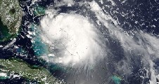
And here below is how the hurricane looks like from the satellite: Click above for Eastern USA, Florida today's actual weather satellite view (wait for loading !)
And here below is how the hurricane looks like from the satellite:


South
Florida Water
Management District

US Geological Survey
|
|
|
|
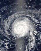
 Hurricane birth Hurricane birth
Progress
and Consequences
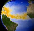
| The Hurricane Alley: Elevated water temperature accross the Atlantic Ocean (yellow) |
 |
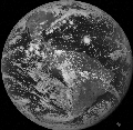 |
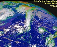
The troubled globe:
We could see tropical storms Georgette, Gaston, Hermine, Frances - and the full moon (Aug.30, 2004) |
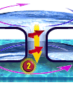
Warm up-spin in the core - cold down-draft in the center of it |
|
|
|
COUNTLESS HURRICANES PASSED OVER THE EVERGLADES - - -
Hurricanes are not just a Florida specialty. They occur on both sides of the equator, called also cyclones or typhoons on the eastern side of the Pacific - where there are warm waters. The Everglades serve as a natural buffer for the deluge whereby their water levels raise and fall as water slowly makes its way to the sea. Seasonal rains and droughts make the water levels fluctuate regularly, occassional hurricanes cause that special flooding.
What makes a hurricane ?
First, warm water - at least 82ºF (28ºC). Several weeks after the Sun shines brightest on the tropics in late June in the Northern Hemisphere, the tropical ocean waters reach their warmest. In the side-image at left here, orange and red indicate where the ocean is 82ºF and warmer. This false-color map of sea surface temperature was made using data taken by the Advanced Microwave Scanning Radiometer-EOS (AMSR/E), aboard NASAs Aqua satellite, and composited for the month of May 2002.
Next, add a disturbance, generally easterly waves off of Africa, comprised of winds resulting from the clash between the hot air from over the Sahara Desert and the cooler air over the Gulf of Guinea. These waves provide the initial energy and spin required for a hurricane to develop.
Every year, the tropical Atlantic becomes a meteorological mixing bowl with all the necessary ingredients for hurricane formation from June 1 to November 30. Typically, the peak of hurricane season occurs from late August to mid-September, which is usually when tropical cyclones of interest to U.S. coastal regions form around the Cape Verde Islands off Africa. NASA satellites are playing an increasing role in helping forecasters determine if all of the ingredients are coming together to create a hurricane. These satellite are also helping researchers track the storms over time and more accurately predict the paths they will take.
For more information, read:
NASA Satellites Extract Ingredients in Hurricane Recipe to Improve Forecasts.
Hurricanes can cut off their energy supply
Hurricanes draw most of their energy from 79-degree or warmer ocean water. The warm water releases humidity into the air where it condenses inside hurricanes, giving off heat to fuel the storm. But the warm water typically extends only 100-150 feet deep. Even when over warm water, slow-moving storms can cut off this energy supply by stirring up the ocean and bringing up cold water from below. Hurricanes over cold water weaken and die.
Strong side-winds, particularly at higher altitudes (wind shear) , can also extinguish the hurricane force by blowing off the top of the vortex.
The global weather pattern known as El Niño tends to create west-to-east high-level winds over the tropics of the Atlantic and Caribbean. This is why fewer hurricanes, especially strong hurricanes occur during El Niño years.
What makes a storm a hurricane
Hurricanes and other cyclones that form in the tropics during summer and fall are very different from the extratropical storms that often form during winter even though both can produce very strong winds and flooding rain.
The seven main characteristics that define a tropical cyclone, including a hurricane, are:
l Hurricanes have no fronts.
l Hurricane winds weaken with height
l The centers of hurricanes are warmer than their surroundings
l Hurricanes and tropical systems form under weak high-altitude winds.
l Air sinks at the center of a hurricane
l Hurricanes' main energy source is the latent heat of condensation
l Hurricanes weaken rapidly over land
Tropical systems are classified into four categories according to its degree of organization and maximum sustained wind speed:
1) Tropical disturbance, tropical wave: Unorganized mass of thunderstorms, very little, if any, organized wind circulation.
2) Tropical depression: Has evidence of closed wind circulation around a center with sustained winds from 20-34 knots (23-39 mph).
3) Tropical storm: Maximum sustained winds are from 35-64 knots (40-74 mph). The storm is named once it reaches tropical storm strength.
4) Hurricane or typhoon: Maximum sustained winds exceed 64 knots (74 mph).
Hurricanes are classified into different categories according to the Saffir-Simpson scale. Hurricanes can also spawn severe weather such as tornadoes as they move inland.
l Hurricane, tropical cyclone glossary
l Understanding hurricane science
l Hurricane life cycle from birth to death
l Latest hurricane news, reports ( http://www.usatoday.com/weather/tg/whurkeys/whurkeys.htm)
Hurricanes can quickly become monsters
One of the big fears of U.S. hurricane forecasters is a storm that quickly grows stronger before hitting land. Even with today's sophisticated observing tools such as satellites and computers to aid forecasts, a storm like the monster that hit the Florida Keys on Labor Day 1935, could kill scores, if not hundreds of people who didn't have time to escape. The 1935 Labor Day hurricane raked the Keys with 200 mph wind gusts, killing 400 people less than two days after becoming a hurricane.
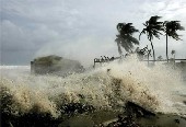
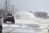
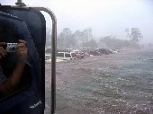
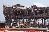
One of the dangerous features of a hurricane is the sea swell that it lifts through its powerful suction. When this swell comes to shallower off-shore waters, it becomes a huge surf surge, reaching up to 25 feet height, like a tsunami that, aided by the rain deluge, can flood and innundate everything far inland.
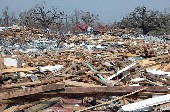
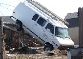
A slow rolling motion of the overall wind, which is thought to be caused by friction with the land, drags high-speed air just above the ground down to the surface. Smashing into the ground, the bursts slow down before being carried aloft on the opposite side of the roll where they re-strengthen and slam downward again. The bursts may be linked to streaks of extreme damage found in some hurricanes such as 1992's Andrew in south Florida. Extreme winds destroy structures, uproot trees and drive debris and knife-sharp glass like projectiles - it is a war zone out there ! Not even a heavy train could take the force of the wind (see a historical photo left).
l Survivor recalls horrific Keys storm
l List of strongest hurricanes 1900 - 2002
l Researching hurricane history
Useful Links for information on hurricanes
|
|