| |
|
|
 |
|
|
|
|
|
|
| |
 Project News Project News
Project
Progress
EVERGLADES PROJECTS
Extensive project descriptions and updates are on SFWMD and US-ACE web pages (click & read details therel).
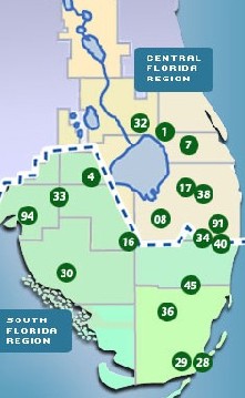
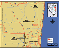
Click project locations on map below and read description in the Table (right)
LOOK AT
MAP |
|
Stimulus money for the Everglades Projects
!
» Read more
|
What's New : |

C-111 Canal work begins in Everglades project
Miami Herald : Jan. 27, 2010
Ground breaking tookplace on a $30 million overhaul of a canal C-111 cut across the southern Everglades in the 1960s.This is third Everglades restoration project to begin this year. The C-111 canal has diverted fresh water from Everglades Nat. Park and Florida Bay, raising salt levels to unhealthy levels for coastal marshes, sea grass and fish.
» Read more - -
Picayune Strand restoration is a keystone for the Everglades
Naples Daily News: Jan.12, 2010 -
Restoring Picayune Strand is one of those rare opportunities to put back what humans destroyed and, in doing so, to revive 55,000 acres of wetlands, sloughs and upland habitats. Picayune Strand is the final piece in a conservation puzzle. With its acquisition and pending restoration there will be a continuous network of natural lands in the western Everglades. » Read more - -
Feds Approve Key Everglades restoration Project
So.Florida SunSentinel: Nov.5, 2009 - Long-stalled Everglades restoration moved forward as the Army Corps of Engineers announced new construction to turn a failed development back to its natural state. The $53 million Picayune Strand project in Collier County becomes the first federally funded project in the state. » Read more - -
Everglades
to get water relief from $81 mln bridge
Reutersl: Sep. 29, 2009:
The U.S. Army Corps of Engineers
awarded an $81 million contract to build a road bridge that will
help restore fresh water flows in Everglades National Park,
nourishing its ecosystem. Beginning in November 2009, Kiewit
Southern Company of Sunrise, FL. will remove 1 mile of the Tamiami
Trail road that crosses the park and blocks natural water flows to
the northeastern Everglades - and replace it with the bridge.
"Tamiami Trail currently acts as a dam that starves the Park of its
lifeblood -- water," said Dan Kimball, superintendent of Everglades
NP.
» Read more
Tamiami
Trail Modifications
Date Added: June,
2009
The
purpose of the Tamiami Trial Modifications component is to identify
the alterations that would improve water flow into Everglades
National Park. An integrated Limited Reevaluation Report and
Environmental Assessment (LRR/EA) for Tamiami Trail has been
prepared.
»Read more ...
Everglades
Restoration gets boost with a new pump
station
Date Added: June 3, 2009
JACKSONVILLE, Fla. – With the 2009 hurricane season
only two days away and after weeks of above average rainfall, a new
pump station located in southwestern Miami-Dade County successfully
began pumping water away from the residential community called the
“8.5 Square Mile Area” .... »
Read more
Federal
stimulus money - -
July 7, 2009
- - is
paying for more than roads and bridges during this economic
downturn. Ecological projects are part of the mix -- and that bodes
well for Florida. Using stimulus dollars to conserve resources that
generate millions of tourist dollars also contributes to our food
and water supplies and generates jobs .....
»
Read more
 Read up on projects
|
|
|
|
FLORIDA AND
EVERGLADES MAP - SATELLITE VIEW
LOCATE THE MAJOR
PROJECTS:
View Larger Map Separately
This Google-Earth map is interactive - zoom in & out
and/or tilt the
view
|
|
Click project
dots/location on the map up-left and read project details and
maps below here
Major Everglades Projects :
|
Project
Location |
| 01 |
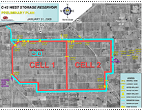
Lake Okeechobee Watershed - Construct two
reservoirs and stormwater treatment area, and remove 150 tons
of phosphorus. |
|

Back to map - click arrow or number
04
|
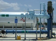
Caloosahatchee River (C-43) West Basin Storage
Reservoir - 170,000 acre-feet, and water depth will vary
from 15 to 25 feet. Constructed on an approximate 10,500-acre
parcel in Hendry County, west of LaBelle (see photo
left-sidebar down), it will store stormwater runoff from the
C-43 basin and reduce excess water flow to the Caloosahatchee
Estuary to maintain its salinity and thus ecological balance
of fauna and biota. |
 |
|
07 |
Indian River Lagoon - South:
To improve surface water management in the C-44 basin and the C-23, C-24
and C-25 basins for habitat
improvement in the St. Lucie
River Estuary and the Indian River Lagoon. Includes: 4
reservoirs for surface water
storage; 3-4 storm-water
treatment areas for water quality improvement by reduction of
phosphorous loading, among other pollutants by using plant
growth within a Stormwater Treatment Area and other means ;
muck removal; artificial habitat construction and natural
storage/water quality areas. |
 |
|
08 |
Everglades Agricultural Area Storage Reservoirs Phase 1 |
|
|
16 |
Modify Rotenberger Wildlife Management Area
Operation Plan - to implement rain-driven operations for
this area and to improve the timing and location of water
depths within the RWMA. Water deliveries are made to
Rotenberger from Stormwater Treatment Area 5.
|
|
|
17 |
North Palm Beach County - Part 1: Construct
structures and other features, and widen a canal. This project
includes six separable elements including Pal-Mar and J.W.
Corbett Wildlife Management Area Hydropattern Restoration, L-8
Basin Modifications, C-51 and L-8 Reservoir, Lake Worth Lagoon
Restoration, C-17 Backpumping and Treatment, and C-51
Backpumping and Treatment. |
|
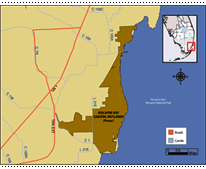
28
|
Biscayne Bay Coastal Wetlands - The project
expands and restores the wetlands adjacent to Biscayne Bay,
enhancing the ecological health of Biscayne National Park by
redistributing excess freshwater runoff from the watershed
away from existing canal discharges and into Biscayne Bay
through existing coastal wetlands to provide a more natural
and historic overland flow.
Includes: Deering Estates
Flow-way, Cutler Ridge Wetlands and L-31E Culverts. Phase 1
project features include, pump stations, canal extensions,
conveyance canals, spreader canals, levees, culverts and
man-made wetlands.
(MOUSE OVER MAP for scenic picture)
|
 |
29
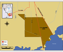
|
C-111 Spreader Canal - To reestablish sheet
flow and hydrologic connectivity between natural areas in the
Southern Glades and Model Lands of South Dade
County:
3,200-acre storm water treatment area; enlarging
pump station S-332E from 50 cfs to 500 cfs; extending the
originally proposed spreader canal to the Model Lands east of
Card Sound Road; installing culverts under U.S. Highway 1 and
Card Sound Road; backfilling C-111 below C-111N to S-197;
removing S-18C and S-197; and backfilling C-110. |
 |
|
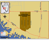
30
|
Picayune Strand (Southern Golden Gate
Estates) -
Picayune Strand includes 55,000 acres between Alligator Alley and Tamiami Trail in southwest Florida, surrounded by preserves and Everglades National Park.
The federal work, to begin in December'09, involves plugging 13.5 miles of drainage canals, removing 95 miles of roads and building a pump station to redirect water. Levees will be installed for flood protection.
The work, expected to take two years, was awarded to Harry Pepper and Associates of Jacksonville. This is a part of a slower ongoing project.
About $40 million of the current price tag will be covered by federal economic stimulus money, which helped speed up the construction timetable.
(MOUSE OVER MAP for scenic picture) |
 |
|
32 |
Lake Okeechobee Aquifer Storage and Recovery
Pilot
Two ASR facilities (Kissimmee River ASR Facility
in Okeechobee County and Port Mayaca ASR Facility in St. Lucie
County) and cycle test the technology for two consecutive
years. |
|
|
33 |
C-43 Aquifer Storage and Recovery Pilot -
Construct an ASR facility and cycle test the technology for
two consecutive years. |
|
|
34 |
Hillsboro Aquifer Storage and Recovery Pilot
- To identify the most suitable sites for
the ASR wells and best configuration of the wells in the
Loxahatchee Basin. It will also provide information about the
local aquifers and the effects to the stored water.
|
|
|
36 |
L-30 Seepage Management Pilot - to determine
the appropriate technology needed to control levee seepage
flow across L-31N canal adjacent to Everglades National Park
and provide the appropriate amount of wet season
groundwater flow that will minimize potential impacts to the
Miami-Dade County's West Wellfield and freshwater flows to
Biscayne Bay. Location: just off Tamiami Trail at
the edge of town and the Everglades. |
 |
|
|
38 |
Acme Basin B Discharge - The project is to
provide surface water to Loxahatchee National Wildlife Refuge
that would otherwise be routed through Basin A to C-51 and
lost to tide. |
|
40
|
Site 1 Impoundment - to supplement water
deliveries to the Hillsboro Canal by capturing and storing
excess water currently discharged to the Intracoastal
Waterway. These supplemental deliveries will reduce demands on
Lake Okeechobee and LNWR. The impoundment pool will also
provide groundwater recharge, reduce seepage from adjacent
natural areas, and prevent saltwater intrusion. Some measure
of flood protection and water quality improvementsmay will
also be provided. There will be some canal and water
controldstructure relocations, canal conveyance improvements.
Aboveground impoundment (13,280 acre-feet storage) is
constructed. |
$ 41.338 million |
| 45 |
Broward County Water Preserve Area - at the
edge of Water Conservation Area 3A/3B. It is to to improve
Everglades water quality. Three project components will
enhance the buffer between residential development and
protected Everglades wetlands, capturing and diverting
stormwater runoff and reducing underground seepage.
It
will provide supplemental water supply deliveries and aquifer
recharge to urban areas, thus reducing demands on Lake
Okeechobee and the Water Conservation Areas.
|
 |
| 91 |
Winsberg Farm Wetlands Restoration -
Construct 175 acres of wetlands and the related equipment to
irrigate wetlands with reclaimed water. |
|
|
94 |
Lakes Park Restoration - Remove exotic species and create flow-way
marsh- |
|
| 95 |
Melaleuca Eradication and Other Exotic
Plants
(everywhere in South Florida & the Keys)
MOUSE over HERE for a PICTURE |
$2.886 million |
| T |
Tamiami Trail Bridge - a controversial project -
finally just approved and started
(October 2009) MOUSE over Project Title for scenic PICTURE |
|
| |
$96 million in Recovery Act
funds are in addition to the previously announced $183.4
million in Everglades restoration funds included in the fiscal
year 2009 federal budget |
|
| |
|
|
| |
|
|
|
Aquifer Storage and Recovery (ASR) - is a highly engineered
approach that proposes to use a large number of wells built
around Lake Okeechobee, in Palm Beach County, and in the
Caloosahatchee basin to store water approximately 1,000 feet
below ground; the approach has not yet been tested at the
scale proposed.
In-ground reservoirs will store water in
quarries created by rock mining.
Conventional surface-water
storage reservoirs, which will be located north of
Lake Okeechobee, in the St. Lucie and Caloosahatchee basins,
in the EAA, and in Palm Beach, Broward, and Miami-Dade
counties, will provide storage of approximately 1.5 million
acre-feet.
Stormwater Treatment Areas
(STAs) are man-made wetlands that treat agricultural
runoff water before it enters natural wetlands.
Seepage management approaches
will prevent unwanted loss of water from the natural system
through levees and groundwater flow; the approaches include
adding impermeable barriers to the levees, installing pumps
near levees to redirect lost water back into the Everglades,
and holding water levels higher in undeveloped areas between
the Everglades and the developed lands to the east.
Removing barriers to sheet flow,
including 240 miles of levees and canals, will reestablish
shallow sheet flow of water through the Everglades ecosystem.
Rainfall-driven water management will
be created through operational changes in the water delivery
schedules to the WCAs and Everglades National Park to mimic
more natural patterns of water delivery and flow through the
system.
Water reuse and conservation
strategies will build additional water supply in the region;
two advanced wastewater treatment plants are proposed for
Miami-Dade County in order to clean wastewater to a standard
which would allow it to be discharged to wetlands along
Biscayne Bay or to recharge the Biscayne aquifer.
| |
| |
|
|
|
|
| |
 |
|
Click the
image for a sophisticated web-based "Project Locator

Click the image for a sophisticated web-based "Project Locator"

Read
or download the latest issue of
Everglades Report with the latest
news and information on the work to restore central and south Florida's
natural environment.
SIGN
UP (click) with the ACE-CERP to receive updates on projects
and/or the Everglades Report by
e-mail.
The projects are mainly executed by:

US Army Corps of Engineers
South Florida Water
Management
District
|
|