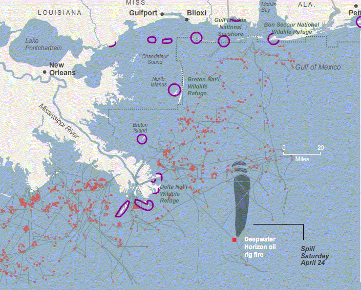
Gulf oil slick movements from Apr. 24 to May 6, 2010
The mighty
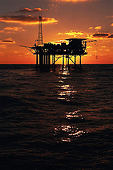
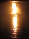
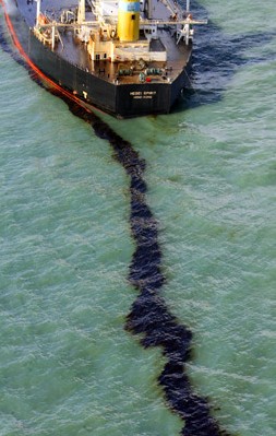
Deepwater Horizon oil rig, operated by BP in the Gulf - exploded, burned and sank. Pipes 5000 ft deep keep spewing crude oil.
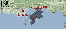
Red dots are the oil rigs : (there are plenty, aren't there ?) Blue lines are pipelines :
The purple circles are areas 'protected' by hastily deployed oil booms in early May.
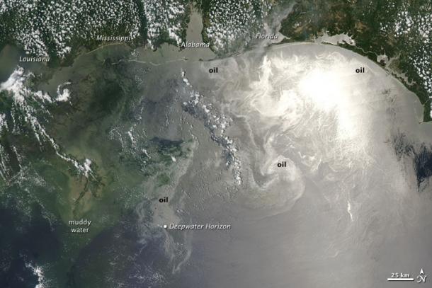
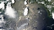
NASA took a new image of the Deepwater Horizon well oil spill that now is visible across the entire Gulf of Mexico. The photo was taken by NASA's Aqua Satellite on June 12, 2010.
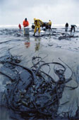
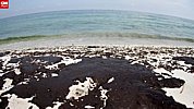
You can see the oil on the beeches, even at Florida you can see the oil reached the beach.
On June 12, 2010, oil from the still-leaking Deepwater Horizon well was particularly visible across the northern Gulf of Mexico when the Moderate Resolution Imaging Spectroradiometer (MODIS) on NASA’s Aqua satellite captured this image at 1:55 p.m. Central Daylight Time.
Oil appears to have reached beaches and barrier islands in Alabama and the western Panhandle of Florida.
Close to the location of the well, the oil appears gray, but to the northeast, it is bright silver. The increased brightness does not necessarily mean the oil is thicker or more concentrated there; it may simply be that the oil is located in the sunglint region of the image—the spot where the Sun’s reflection would appear if the water surface was as perfectly smooth as a mirror.
Normally, waves blur the Sun’s reflection, diffusing its brightness. Oil smoothes the water surface, making it a better mirror. When the slick appears in that part of the image, viewing conditions are ideal, and the patches and ribbons of oil are extremely bright. When the oil slick is not in the sunglint part of the image, however, it may be imperceptible against the dark background of the ocean.
There are hundreds of oil rigs and a network of underwater pipelines drawing oil from deep in the seabed of the Gulf of Mexico. The public and officials were being assured of the sophistication and safety of technologies used. The recent catastrophic rig explosion event proved that there is no such thing as "safe" off-shore oil extraction. The NASA satellite photo below shows the oil slick position as of June 12, 2010 starting to reach northern Florida beaches.
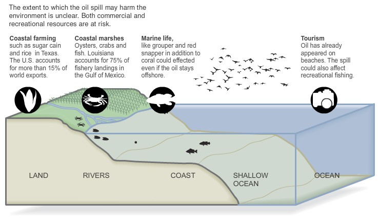
Oil spill consequences :
The Gulf oil spill and the Everglades ??
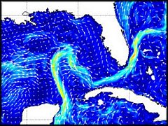
The Loop Current originates along the south shores of the Yucatan Penninsula (southern Mexico). Then it 'loops' through the Gulf of Mexico, its path oscillating as it constantly changes. It leaves the Gulf sneaking between theFlorida Keys and Cuba to become the Gulf Stream. Washing Florida east coast it peels off to start its way accross the Atlantic.
There could be no doubt that the current will pick oil from the spill - sooner or later. How much - - ?
It will be around for a long time.
Florida’s Loop Current could intersect with oil slick, scientists say
BostonHerald.com - by David Fleshler and William E. Gibson / Sun Sentinel
May 4, 2010
FORT LAUDERDALE, Fla. -- Outer bands of the powerful Loop Current moved north to within 31 miles of the destroyed wellhead, spewing thousands of barrels a day. If the current reaches the spill, it could drag the slick south to the Florida Keys within days, and push it north to Broward and Palm Beach counties in a week to two weeks, marine scientists said.
"If it continues to move in that direction, and there is no reason why it shouldn’t, the Loop Current could very well be at the wellhead," said Bob Weisberg, who is using satellite images to track the slick at the College of Marine Science at the University of South Florida. "So there is a strong likelihood that at some point in the future oil will be entrained into the Loop Current."
Florida Gov. Charlie Crist on Monday extended a state of emergency south to Sarasota County. Everglades National Park, Big Cypress National Preserve, Dry Tortugas National Park and Biscayne National Park began disaster preparations, establishing a response team comparable to that set up for hurricanes, and Tuesday they will begin assessing vulnerable natural systems, such as mangrove shorelines
"We certainly hope it’s not going to hit the park," said Linda Friar, spokeswoman for Everglades National Park. "We are concerned. There’s potential for the oil to impact Everglades, Dry Tortuga, Big Cypress and Biscayne."
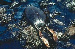
Florida faces the risk of gooey oil washing up on beaches, smothering sea turtle hatchlings, ruining shorebird nests, contaminating coral reefs and killing a wide range of coastal wildlife. One scientist told the Coast Guard to consider laying a floating boom from Key West to Palm Beach to protect the coast.
In years of debates over expanding offshore drilling in the Gulf, environmentalists had invoked the danger of a slick riding the Loop Current through the Florida Straits. Now, even without more drilling, the danger appears to be real.
The current, which moves 2 to 6 mph, turns into the Gulf Stream, which runs near to the shores of Miami-Dade, Broward and Palm Beach counties.
"If you are standing on a beach in Miami, you can throw a stone at times into the Gulf Stream," Weisberg said. If winds blow an oil slick toward shore, "you are likely to get oil on the beach in Miami."
The Florida Department of Environmental Protection said there are no projections of oil reaching Florida beaches through Thursday.
Some part of that glob almost certainly will come to South Florida, he said.
It’s not a question of if, but when. It won’t be tomorrow. Will it be by the end of next week or so?
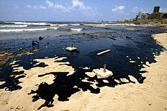
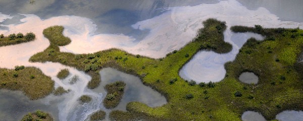
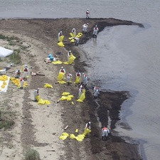
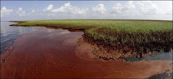
ABOVE: When the oil slick lands in an environment like Luisiana coast marshes
and bayous, somewhat similar to Florida Bay, its mangroves and the lower
Everglades, it can persist there for a long time - affecting profoundly the whole ecosystem. The mangroves likely could not survive in such polluted environment.
Click the picture above for VIDEO and see what did NOT work !
Could spreading hey, as suggested by some, help in soaking up the floating oil ??
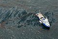
LEFT: Flying over the Gulf of Mexico in AUGUST 2011 shows still plenty of floating oil. The spill has NOT "disappeared".
Worth seeing:
CLICK these images (on the right here) for the original CNN videos and pictures
Pres. Obama and FL Governor Charlie
Crist
"on the spot" :
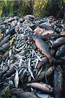
The extent of the ecological damage the Deepwater Horizon disaster will cause in Mississippi and the Gulf at large is unclear, a source of debate among scientists, environmentalists and politicians. Some experts say fisheries and marine life will be devastated and take years to recover.